The Rideau Canal in Ottawa
by
Ken W. Watson
Note: This article first appeared in the Fall 2014 edition of Rideau Reflections, the newsletter of the Friends of the Rideau (www.rideaufriends.com).
 The 8 km section of the canal from the Ottawa Locks to Hogs Back is usually referred to as being a completely excavated channel, but that's not true. Colonel By used the slackwater system in Ottawa, taking advantage of existing topography to avoid excavation, just as he did for the rest of the Rideau Canal. The 8 km section of the canal from the Ottawa Locks to Hogs Back is usually referred to as being a completely excavated channel, but that's not true. Colonel By used the slackwater system in Ottawa, taking advantage of existing topography to avoid excavation, just as he did for the rest of the Rideau Canal.
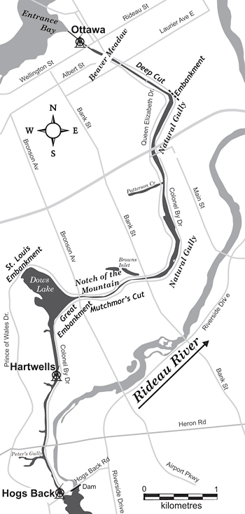
Once Entrance Bay had been established as the starting point for the canal, the challenge was to connect the canal to the Rideau River. Just beyond the bedrock top of Entrance Valley was a spot known as the Beaver Meadow, which is exactly as the name describes, a meadow area created by beavers damming a stream (beavers were creating slackwater long before Colonel By used this technique for canal construction). This natural feature was taken advantage of to become a canal basin. "The Swamp, generally called the Beaver Meadow, at the head of the Entrance Valley, afforded much facility for forming the proposed works, and was selected as a proper site for a Basin, or Reservoir, at the head of the projected Eight Locks" (Thomas Burrowes, 1826). The basin, now filled in, was in the area of present-day Confederation Park, the Mackenzie King Bridge and the Ottawa Convention Center.
Colonel By's first plan was to run an excavated cut from the Beaver Meadow straight to the Notch of the Mountain (near Dows Lake) and then follow the present day route of the canal but come into the Rideau River below (downstream) of Hogs Back (see map on page 2). When the area was surveyed, and Colonel By had solidified his plans for a full slackwater system, he changed the route to take advantage of what nature provided, a 3 km long gully, an area already excavated by nature, the Natural Gully.
From the Beaver Meadow, he had the Deep Cut excavated until it intersected the Natural Gully. The exit of the gully was blocked off with an embankment and the gully was followed south to its end, a low point in a ridge crossing the route of the canal known as the Notch of the Mountain. The gulley required little work other than grubbing it out. To quote part of Colonel By's 1831 progress report: "From the Beaver Meadow to the Natural Gully a distance of 1053 yards, the Excavation was through clay and from its great depth is termed the Deep Cut; at the North Entrance of Natural Gully, a Mound of Earth or Dam of 15 feet in height and 315 feet in length was to be constructed to prevent the water escaping down a Ravine; the Gully in question is 3300 yards in length, an average breadth 83 yards, from its south [north] entrance to the Notch of the Mountain."
An excavation through the Notch of the Mountain, known as Mutchmor's Cut (named for a settler living in that area), brought the canal to Dow's Great Swamp. Colonel By planned a mounded aqueduct (a canal channel sitting on a large mound of earth) to cross the swamp, but again, nature provided a less expensive solution. A few hundred metres down the swamp was a narrowing, the “Ridge of the Swamp”, an area that could easily be dammed. Work had already started on the mounded aqueduct which was now converted into being simply an embankment (the Great Embankment). Together with the St. Louis Embankment at the Ridge of the Swamp, they created a lake as part of the canal route. As one of the Royal Engineers, Lt. Frome, succinctly put it: "Dow's Great Swamp, which, by means of two massive earthen embankments, is converted into a pool 20 feet deep."
Nature did not help Colonel By for the rest of the route except for the fact that he didn't have to excavate any bedrock (since none was found between the Ottawa Locks and Hogs Back). But he did take advantage of topography by taking two of the three planned lift locks for Hogs Back and moving them to Hartwells which saved quite a bit of excavation.
In the end, almost half (3 km of the Natural Gully and 0.5 km at Dow’s Lake) of the canal in this area is flooded topography, not an excavated ditch.
-Ken Watson
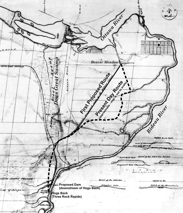 “Sketch of the Route of the Rideau Canal from Grand Entrance Bay to the foot of the Black Rapids”, National Archives of Canada, NMC 21762, not dated.
In this c.1827 map we see the first proposed route for the canal in Ottawa. From the Beaver Meadow it made a beeline to the Notch of the Mountain and then followed close to the present-day route but came out downstream of Hogs Back (as opposed to the present day location of the canal which comes out at the head of (above) the rapids at Hogs Back).
Another version of this map has the notation “The canal … and the dam at the Hog’s back (50 ft high) is another method proposed by Lt. Col. By of ascending to the still water at Capt. Wilson’s.” Captain Wilson was an early settler located on the east side of the Rideau River, about halfway between Mooneys Bay and Hunt Club Road.
|