
 Hiking the Rideau Corridor is a fun (and healthy) way to enjoy the scenery and view the sights. This section of the Rideau website simply presents a few hiking resources, mostly lists of the hiking trails available in the Rideau area with links to appropriate websites describing these in greater detail. Note, the listings do not include trails inside the City of Ottawa or City of Kingston (see links page for websites related to those cities) Hiking the Rideau Corridor is a fun (and healthy) way to enjoy the scenery and view the sights. This section of the Rideau website simply presents a few hiking resources, mostly lists of the hiking trails available in the Rideau area with links to appropriate websites describing these in greater detail. Note, the listings do not include trails inside the City of Ottawa or City of Kingston (see links page for websites related to those cities)
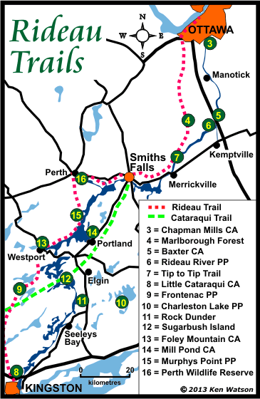
The two longest trails are the Rideau Trail, extending from Kingston to Ottawa and the Cataraqui Trail, part of the Trans-Canada trail system, extending from Strathcona to Smiths Falls. Outside of those, there are dozens of other smaller trails, located in parks and conservation areas.
Trail Tips/Etiquette - this page lists some hiking tips and general hiking etiquette.
Accommodations - need a place to stay in the Rideau area? This section lists campgrounds, B&Bs, inns, motels and lodges.
The Regional Trails
Rideau Trail (~200 km one way, 300 km including loops & side trails) - the Rideau Trail is the longest trail in the area, extending from Kingston to Ottawa. It is a hiking only trail with some cross country skiing and snowshoeing. It is maintained by the Rideau Trail Association. All maps and associated text descriptions are now available as free PDF downloads from www.rideautrail.org/discover-the-trail/maps/. Website: www.rideautrail.org. A membership in this non-profit group is highly recommended if you plan on using the trail - your dues go to help maintain the trail: www.rideautrail.org/get-involved/become-a-member/. You can also make a donation to the Rideau Trail Association: www.rideautrail.org/get-involved/donations/
Cataraqui Trail (104 km) - while not quite a regional trail, the Cataraqui Trail extends from Strathcona to Smiths Falls. It is part of the Trans-Canada trail system and follows an old railway bed, so it is a very easy hike. Full details, including a trail map, are available on the Cataraqui Trail website. Website: www.cataraquitrail.ca. Also consider taking out a membership or make a donation if you plan to use the trail - fees go to help maintain the trail
The Northern Trails
(Ottawa to Smiths Falls)
Chapman Mills Conservation Area (1.5 km): Located on Prince of Wales Drive in Ottawa. Features walkways and boardwalks along natural shoreline and wetlands. Website: www.rvca.ca/conservation-areas/chapman-mills
Marlborough Forest - on County Road 6 west of North Gower and north of Burritts Rapids. This forested area is owned by the City of Ottawa. There are many trails and abandoned roadways. Part of the Rideau Trail also runs through this forest.
Baxter Conservation Area: Located on Regional Road 13 (Dilworth Drive) off Highway 16, south of Kars. It features swimming, hiking and year round programs. It has a 5 km walking trail, an Interpretive Centre, marsh boardwalk, toilets, a beach, change house, small boat launch, picnic tables and a picnic shelter. Website: www.rvca.ca/conservation-areas/baxter
Rideau River Provincial Park (3.5 km): Located on County Road 5 just across the Rideau River from Kemptville. It has a has a 3.5 km walking trail along the shore of the Rideau River. Website: www.ontarioparks.com/park/rideauriver
Ferguson Forest Centre Nature Trails: Located just northwest of Kemptville, along Kemptville Creek, the Ferguson Forest Centre has 8 nature trails, varying in length from 0.3 to 3.9 km. Website: www.fergusonforestcentre.ca/visit/trails
Tip to Tip Trail (4 km): Located at Burritts Rapids, the starting point is the Burritts Rapids Lockstation on Rideau River Road (Cty Rd. 23). The trail takes you along Burritts Rapids Island and there are interpretive stops along the trail. Website: www.rideau-info.com/driving/map-burritts-rapids.html
The Southern Trails
(Kingston to Smiths Falls)
Little Cataraqui Creek Conservation Area: Located 2 km north of Hwy. 401 on Division St. (County Road 10), Kingston. Offers 5 trails of varying lengths, plus picnic tables, washrooms, canoe rentals and an outdoor centre. Website: cataraquiconservation.ca/pages/little-cataraqui-creek
Frontenac Provincial Park (150 km): Located on Salmon Lake Road, north of Sydenham, the park features 12 different trails ranging in length from 1.5 to 21 kilometres. Many are wilderness trails, sights include waterfalls, beaver ponds, lakes and abandoned homesteads and mica mines. Part of the Rideau Trail crosses the southern side of the park. Website: www.ontarioparks.com/park/frontenac
Charleston Lake Provincial Park (30 km): Located on County Road 3 south of Lyndhurst, this park features 6 different trails ranging in length from 1.6 to 10 kilometres. Sights include various forms of wildlife habitat, shorelines, wetlands, pioneer homesteads and lake viewpoints. Website: www.ontarioparks.com/park/charlestonlake
Rock Dunder (~3 km): located near Morton. Take Stanley Lash Lane (located at the south end of Morton, to the west off of Highway 15) to the trailhead parking area (stay left). The trail takes you to the edge of Morton Bay and then up to the top of Rock Dunder (about a 45 minute hike). Owned and operated by the Rideau Waterway Land Trust. Website: www.rwlt.org/rockdunder/
James H. Fullard Nature Reserve (2.8 km): located near Elgin. Take Davis Lock Road (off Hwy. 15). The trailhead is about 7 km to the west of Hwy 15. The trail leads to a view of the Murphy Bay Wetlands (Opinicon Lake). Owned and operated by the Rideau Waterway Land Trust - please respect their rules. Website: www.rwlt.org/Fullard
Foley Mountain Conservation Area (6 km): located near Westport, off County Road 10, it offers swimming, group camping, hiking, educational programs. It also has a 6 km walking trail, an Interpretive Centre, toilets, beach, change house, picnic tables and a picnic shelter. Website: www.rvca.ca/conservation-areas/foley-mountain
Mill Pond Conservation Area (15 km): located on Briton-Houghton Bay Road, off Highway 15 between Portland and Lombardy. Offers natural habitat and a seasonal sugarbush program. It also has a 15 km walking trail, a seasonal Interpretive Centre, toilets, small boat launch, picnic tables and a picnic shelter. Website: www.rvca.ca/conservation-areas/mill-pond
Murphys Point Provincial Park (20 km): Located 19 km south of Perth on County Road 21, the park has 5 hiking trails ranging in length from 1 to 5.5 kilometres. Sights include interpretive displays, beaver ponds, Silver Queen Mica Mine, viewscapes of Big Rideau Lake, beaches and mixed forest. In addition, 6.5 km of the Rideau Trail traverses the park. Website: www.ontarioparks.com/park/murphyspoint
Perth Wildlife Reserve (4 km): Off County Road 1 between Perth and Rideau Ferry. It features a wildlife area, including an overlook of the Tay Marsh. It provides for goose habitat with a goose landing zone and features a 4 km walking trail. It also has toilets. Website: www.rvca.ca/conservation-areas/perth-wildlife-reserve
AOG Art Trail (4 km): located at 42 Leacock Road, Frankville, this trail system offers a unique experience with more than 40 pieces of sculpture, photography, murals, and other art from local and international artists along the way. It is open year-round and has free access. Website: aoggallery.ca
Lockstation & Area Walking Tours
Several of the Rideau lockstations have walking tour brochures including Ottawa, Burritts Rapids, Nicholsons, Merrickville, Jones Falls, and Kingston Mills. You will find downloadable versions of these brochures (PDFs) on the Brochures Page of this website.
Community Walking Tours
Trails are not the only places one can go for a hike. Consider doing one of the many village or town walking tours. For a full listing of these, together with tour maps, have a look at the links on the Community Histories Section of this website.
|