Mountain Climbing - By Boat
by
Ken W. Watson
Note: This article first appeared in the Summer 2011 edition of Rideau Reflections, the newsletter of the Friends of the Rideau (www.rideaufriends.com).
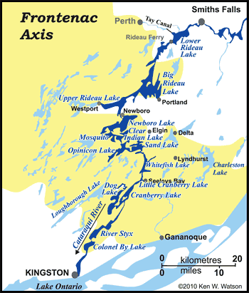
There are few places in Canada where it can be said "I boated over a mountain." Well, if you’ve boated the Rideau from Kingston to Smiths Falls, you can boast to all your friends that you did, truly, boat over a mountain. “What mountain?” you ask. A mountain that was part of the Grenville mountain range, what is known today as the Frontenac Axis.
When Colonel By looked at the difficulties of building a navigable waterway to connect the Ottawa River to Kingston, he knew that he had many challenges that had to be overcome. “Providing navigation over a mountain” wasn’t one of them, but that’s exactly what he had to do. He knew from the existing surveys that he was climbing to a summit, the top of which was at Newboro. He also knew that the area south of Oliver’s Ferry (today’s Rideau Ferry) marked a geological transition to different types of rocks than those found to the north.
His initial concern with those rocks was that they weren’t suitable as building blocks for the locks and dams. They were too hard and fractured to be shaped into blocks – he had to find more suitable rocks, such as sandstone or limestone, that were located outside of this area. And, at Newboro, when he dug down he found out just how difficult it is to excavate through some of these rocks, eventually adding a lock at Narrows to avoid having to excavate any deeper at Newboro.
 So, what are these rocks anyway? They are very old rocks, part of what’s known as the Canadian Shield. They were originally formed 1.35 to 1.06 billion years ago in a shallow marine environment. Then, about 900 million years ago they were metamorphosed (deformed by heat and pressure) to form the rock types we see today; mostly quartzite, marble and gneiss. Near the end of this deformation period, granitic rocks (plutons of granite, syenite, and monzonite) were intruded. Other rock types that were added to the mix include migmatite, gabbro and pegmatite. So, what are these rocks anyway? They are very old rocks, part of what’s known as the Canadian Shield. They were originally formed 1.35 to 1.06 billion years ago in a shallow marine environment. Then, about 900 million years ago they were metamorphosed (deformed by heat and pressure) to form the rock types we see today; mostly quartzite, marble and gneiss. Near the end of this deformation period, granitic rocks (plutons of granite, syenite, and monzonite) were intruded. Other rock types that were added to the mix include migmatite, gabbro and pegmatite.
The metamorphism occurred during a mountain building event as the proto-North American continental plate collided with the proto-South American plate. The mountains that were built as a result of this were analogous to the Himalayan or Andes mountain ranges today (really big!). They extended from Labrador to California and into Mexico.
When the collision stopped, the mountains ceased to grow and ever-present erosion started to wear them down. Erosion changed to deposition when continental drift brought the eroded remnants of our part of the mountain range to the area of the equator, where, 520 to 460 million years ago, a shallow sea deposited new marine sediments on top of these older rocks. These sediments turned into the limestone, sandstone, dolomite and shale that we can see on either side of the Frontenac Axis.
The Frontenac Axis is exposed today because it represents a topographic high – the remains of the highest part of the original mountains. The thickness of sediments deposited over these higher parts of the old mountain range was less than on either side and this allowed those sediments to be eroded away, exposing these old rocks.
As much as Colonel By found these rocks more annoying than useful, by the mid-1800s mineral discoveries were being made in the rocks of the Frontenac Axis, which led to some small scale mining that continued into the early 20th century. The first mine on/near the Rideau Canal (excluding the small scale iron mining near Lower Beverley Lake) was the iron mine on Iron Island near Newboro opened by the Chaffey brothers, John, Benjamin and Elswood, in about 1850. By the late 1800s, numerous small phosphate mines were being operated (for fertilizer, most was shipped to England) and by the turn of the century, there were many small mica mines in operation.
After the opening of the Rideau Canal, the lands underlain by these rocks were occupied by homesteaders, who found the poor soil cover a challenge for any type of farming. By the 20th century, these farms were being abandoned with a new activity, cottaging, taking their place.
The rocks of the Frontenac Axis provide an ideal environment for recreation activities. The topographic expression (hilly) of these rocks host numerous lakes. These lakes provide for great recreation opportunities including boating, fishing, swimming - uses that continue to this day. They also form what can only be described as pretty (aesthetically pleasing) landscapes. And these pretty landscapes provide a rich ecological habitat for numerous species of plants and wildlife.
So, this summer, get into your boat, head out to the locks between Kingston and Smiths Falls and do some mountain climbing (no hiking boots required).
- Ken Watson
|