Your location: Rideau Canal Home Page > Watson‘s Books > Engineered Landscapes > Synopsis of Contents

SYNOPSIS
What did the Rideau Route look like prior to the building of the locks and dams in 1826-1831? What did the early surveyors see? How much flooding did the building of the Rideau Canal cause? These questions and more are answered in this book that investigates the pre-canal geography of the Rideau Canal and the amount of flooding caused by the building of the locks and dams.
The book is divided into three parts:
Part 1 describes the pre-canal geography based on survey descriptions, maps and some recent field investigations. This section begins with a review of the geographic shaping of the Rideau Corridor and the pre-canal human use and occupation. This is followed by a geographic description of the pre-canal waterway, primarily a description of the rapids and falls that had to be overcome to create a navigable waterway. The final section of Part 1 consists of first hand accounts of the pre-canal Rideau Route, maps and transcriptions of the first three full route surveys, those of Lt. Gershom French in 1783, Lt. Joshua Jebb in 1816, and Samuel Clowes in 1823 and 1824. The accounts of these surveys have not been previously transcribed and are presented in this book for the first time.
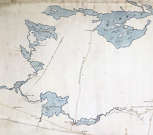 |
Central Portion of Lt. Joshua Jebb's 1816 Survey Map (looking northwest)
This is a section taken from the central portion of Jebb's map that is reproduced in colour, on 3 pages (including 2 fold out 11" x 17" pages) in Engineered Landscapes.
|
Part 2 briefly reviews details of the building of the dams and locks, the channel engineering, and the exact levels of flooding brought about by the building of the Rideau Canal. Every section of the Rideau Canal has been subject to some degree of flooding, the amount of this flooding has never been previously determined. This book attempts, through historical research and present day field investigations, to quantify the flooding brought about by the building of the Rideau Canal.
Part 3 provides an overview of recent field investigations into some of the questions that arose from the initial research for this book, principally to scientifically delineate portions of the now inundated pre-canal landscape.
Each of the above parts is profusely illustrated with period maps, period paintings and illustrations.
Pre-Canal
Prior to the establishment of mill dams and the building of the Rideau Canal, the Rideau Route spanned three watersheds; those of the Rideau River, the Gananoque River, and the Cataraqui River. Native Americans made use of these rivers to access hunting and fishing grounds in the Rideau area and as travel ways between Lake Ontario and the Ottawa River. Two canoe routes were used: one up the Gananoque River to its western head in Sand Lake; and one up the Cataraqui River, to its head in Loughborough Lake and from there to Opinicon Lake. These two routes merged in Opinicon Lake and the travel way continued to Rideau Lake and then down the Rideau River to the Ottawa River. The area occupied by present day Whitefish Lake and Cranberry Lake was an impenetrable marsh. It was not navigable by canoe prior to the building of mill dams in the early 1800s.
The first survey of the Rideau was done in 1783 by Lt. Gershom French who went from Montreal, up the Ottawa River, up the Rideau River, through the Rideau lakes to Sand Lake and then down the White Fish River to the Gananoque River and from there to the St. Lawrence River. At the time, there were no known European settlements on the Rideau Route. Settlement started in 1784, on the Cataraqui River, with the completion of the King’s Mill at the Cataraqui Falls, the present day location of Kingston Mills. On the Rideau River, the first settlement took place in about 1790 with Abel Stevens’ mill at the Great Falls, the location of present day Merrickville. These mills were soon followed by others, established by entrepreneurs who harnessed the water power provided by rapids and falls along the Rideau Route.
It was one such entrepreneur, Lemuel Haskins, who changed the flow of two watersheds. Haskins erected his first mill dam in 1803-1805 at White Fish Falls, the location of present day Morton. This backed up water on the White Fish River, drowning large areas of forest and forcing the water over the Cranberry Flood Marsh to the Cataraqui River. Sometime prior to 1816, Haskins also erected a dam at the Round Tail on the Cataraqui River (just above Upper Brewers) which flooded the entire area between there and Jones Falls and made the Cranberry Marsh navigable by canoe.
When Lt. Joshua Jebb of the Royal Engineers did a survey of the Rideau Route in 1816, he was looking for a route with a navigation depth of about 3 feet (0.9 m) that could be traversed using batteaux. He recommended an alternate route to the present day course of the canal, one that bypassed all of the Rideau lakes by leaving the Rideau Route at Irish Creek and rejoining it at White Fish Falls (Morton).
In the early 1820s, the Macaulay Commission was set up by the province of Upper Canada to investigate inland water routes, including the Rideau Route. They hired Civil Engineer Samuel Clowes who surveyed the Rideau in 1823 and 1824. He recommended the Rideau lakes route over the Irish Creek route and presented a proposal with options for navigation depths of 4, 5, and 7 feet (1.2, 1.5 and 2.1 m). At the time of Clowes’ surveys, the flow of the waters along the Rideau Route had already been altered by mill dams at many of the rapids. Clowes’ proposal was for a conventional canal system, with towpaths, and in most cases, canals cuts, to bypass rapids. However, for the Cranberry Marsh section, Clowes proposed to achieve navigation by drowning it with the use of dams. Clowes may have proposed this after seeing this principle in actual use; navigation of the Cranberry Marsh by flooding had already been established by mill dams. This was a pre-cursor to the concept of a slackwater navigation system for the Rideau.
The final pre-canal surveys were made in 1827. The diaries of two of the surveyors, John Burrows and John MacTaggart (published in “Sights and Surveys” by Edwin Welch), discuss their suggestions for establishing navigation around various rapids. These discussions incorporate the fully developed concept of a slackwater navigation system for most of the Rideau Route; flooding rapids rather than bypassing them with canal cuts.
Building of the Canal
The decision to build the Rideau Canal was finalized in 1826. Lt. Colonel John By of the British Royal Engineers was made Superintending Engineer for this project. This meant that he not only supervised the project, but he also did most of the engineering design work of the canal. Colonel By planned a slackwater navigation system. This decision was to reshape the geography of the entire Rideau Route. Colonel By also saw that steamboats were the wave of the future. He did away with proposals for tow-paths and lobbied to have the locks made larger, to better accommodate the new steamboats that he anticipated would be used. He also adapted to Canadian conditions in his engineering, including adding waste water weirs to control water levels and prevent problems with spring flooding.
The dams erected as part of the building of the Rideau Canal flooded virtually every section of the route except for a remnant of the Rideau River, bypassed by a canal cut in Ottawa. Flooding depths ranged from a few cm to 13.7 m (few inches to 45 feet). Parts of the old Cataraqui River are now Colonel By Lake, River Styx, and Cranberry Lake. Part of the former White Fish River is now part of Whitefish Lake. Much of the former Jones Falls Rapids is now part of Sand Lake.
The use of this slackwater system meant that less than 10 percent of the 202 kilometre (125 mi.) length of the Rideau Canal required man-made structures such as canal cuts and locks. The rest of the navigation way was created by flooding or by following existing lakes and rivers along the route.
Present Day
The Rideau Canal remains essentially unchanged from when it first opened for navigation in 1832. Water levels in various sections have generally fluctuated by less than 0.6 metres (2 feet) since that time. However, many of the present day expanses of flat water hide a secret. Sitting beneath them is the original pre-canal topography, including the channels of the old rivers and rapids. These can be “seen” today using modern underwater scanning equipment such as echosounders and side scan sonar. Work has begun to map this inundated topography and reveal exactly what the pre-canal Rideau looked like.
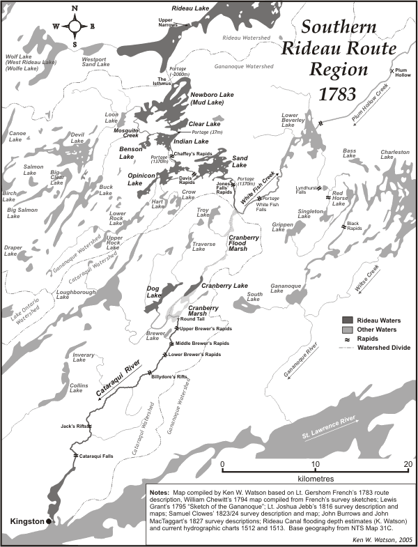
Ken has re-constructed the pre-settlement Rideau Route. Full descriptions of that route are included as well as map illustrations such as the above. The pre-settlement Rideau is shown on 3 maps which indicate the watershed divides, the pre-canal rivers, lakes and rapids and the various portages that canoe travellers had to take.
Return to Engineered Landscapes Page
Comments: send me email: Ken Watson
©1996- Ken W. Watson
|