Your location: Rideau Canal Home Page > Rideau Lockstations > Upper Beveridges Lock 34
| Number of locks: 1 |
Total Lift: 3.9m ( 13 ft.) |
Lock Through Time: 15 min |
| Chart No: 1513 (Sheet 1) |
GPS:1 N 44° 52.615' W 76° 08.730' |
| Chart Sales: No |
Lockstation Tel: 613-267-2036 |
| Washrooms: Yes2 |
Drinking Water: Yes3 |
Day Use Docking: Yes |
| Overnight Mooring: Yes |
Docking4 Upstream:
69m/225' |
Docking4 Downstream:
Note 1 |
| Ice: No |
Power: No |
Boater Camping:5 Yes |
| Boat Launch: No |
Picnic Tables: Yes |
BBQ Grills: No |
| Parking: Yes |
Public Telephone: No |
Self Guided Trail: Yes |
Hwy Access: 300 m N. of Port
Elmsley Road (Cty. Rd.18) |
Lock Connects: Tay Canal to Tay Canal |
| Civic Address: 171 Beveridges Lock Road, Drummond/North Elmsley, Ontario |
Special Notes: To ensure passage, boaters must arrive at least 30 minutes prior to closing.
|
Of Interest: When the Rideau Canal was built, there was no water connection to Perth. So local Perth residents had the Tay Canal built, it opened with five small locks in 1834. However, by 1865 it had fallen it disrepair, so, with the support of local MP John Haggart (son of John Haggart, the canal contractor for Chaffeys Lock), a new canal was proposed. Two locks, with the same design as Rideau locks, were built in a canal cut leading from the Tay River to Beveridge Bay of Lower Rideau Lake, between 1884 and 1887, and the route was deepened by dredging. The 10 km long (6.5 mi) Tay Canal, known for a time as “Haggart’s Ditch,” features some of best wildlife viewing on the Rideau and leads to the pretty town of Perth. Boat tie up is available at Last Duel Park in Perth, or boats that are less than 1.8 m (6 feet) high can proceed right into town. There is lots to do and see in Perth. Take an interesting historic walking tour. Visit the Perth Museum, in the historic Matheson House.
|
Notes: Closest gas is Rideau Ferry. Groceries, hardware, gift shopping, etc. available in Perth.
Parks Canada has four oTENTiks at this location available for rent
An interesting historic note is that the Tay Canal and the Beveridges Locks were not originally part of the Rideau. The present day locks were built between 1883 and 1887, replacing an earlier set of wooden locks constructed in 1834. Locally the Tay Canal is known as "Haggart's Ditch" after John G. Haggart, local MP, who held the portfolio of Railways and Canals and who poured much government money into upgrading the Tay Canal and constructing the Beveridges locks. |
|
1) GPS data should not be used for navigation. See the GPS page.
2) Washrooms are wheel chair accessible.
3) Unless indicated otherwise, water at the lockstation is potable.
4) Includes both blueline and greyline docking - see Lockstation Docking Page.
5) Allows tent camping for those arriving by water and also for cyclists and hikers.
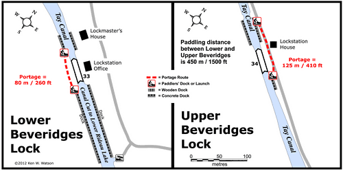
Note 1: 240' of blueline docking between U. and L. Beveridges is available during lock operating hours.
|
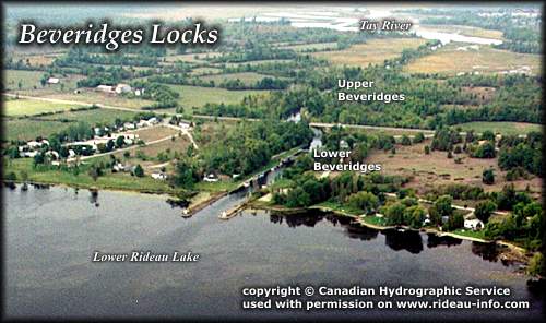 |
Beveridges Locks looking NorthwestLocated a couple of hundred metres up from the Lower Beveridges lock, these locks are operated by the same canal staff that operate Lower Beveridges. If you arrive from Perth, there is a "hotline" that allows you to telephone the staff who will come up and lock you through. If coming from Lower Beveridges, the staff will take the road and will be waiting for you at the lock.
photo copyright © Canadian Hydrographic Service - used with permission |
Comments: send me email: Ken Watson
©1996- Ken W. Watson
|