Your location: Rideau Canal Home Page > Map Page > Maps Lists & Sources
Maps, Maps, Maps
Looking for a map that covers the Rideau region. Check below for a listing of different maps that cover this region.
Hydrographic Maps (Nautical Charts)
There are two types of hydrographic maps available for the Rideau - the official government hydrographic charts and the Trak maps.
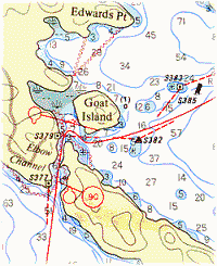 Hydrographic Charts Hydrographic Charts
Hydrographic charts are produced by the Canadian Hydrographic Service. These charts contain depth readings as well as information on all the navigation markers along the waterways. ALL boaters should carry an appropriate set of charts with them on any boating outing. These are the only maps officially sanctioned for navigation.
The Rideau Waterway Charts are at a scale of 1;20,000 and have water depths marked in feet. Water depths are shown approximately every 500 to 1,500 feet (150-500 metres), sometimes closer in areas with rapid water depth changes. In addition, navigation markers (with numbers) are shown and the locks are shown in detail with 1:4,800 scale inserts.
The charts are marked with latitude and longitude co-ordinates based on NAD83 (remember to adjust your GPS unit accordingly).
| Chart No. |
Title |
Scale |
Edition |
| 1512 |
Rideau Waterway - Ottawa to Smiths Falls |
1:20,000 |
Mar-04-2005 |
| 1513 |
Rideau Waterway - Smiths Falls to Kingston |
1:20,000 |
Jan-05-2007 |
| 1514 |
Ottawa River - Carillon to Papineauville |
1:20,000 |
Jul-24-1998 |
| 1515 |
Ottawa River - Papineauville to Ottawa |
1:20,000 |
Jul-24-1998 |
| 1510 |
Ottawa River - Lac des Deux Montagnes |
1:30,000 |
Jul-07-2003 |
| 2017 |
Lake Ontario - Kingston Harbour and Approaches |
1:15,000 |
Jul-13-1990 |
Please note that nautical charts have their information periodically updated with a "Notice to Mariners" which details changes since the chart was produced. To view these notices and amend your current chart, please visit the Notice To Mariners Website
The Rideau navigation charts can be purchased from World of Maps. In addition, most of the lockstations along the Rideau sell the Rideau charts.
You can view the charts on-line by going to the Navionics website and selecting the Chart Viewer option.
Topographic Maps
There are two main types of topographic maps, the National Topographic Series (NTS) at scales of 1:250,000 and 1:50,000 and the Ontario Base Map (OBM) series at a scale of 1:10,000.
National Topographic Maps (NTS)
The National Topographic Series Maps are produced by the Canadian Federal Government. The most detailed are the 1:50,000 series, which have 25 foot or 10 metre (depending on the age of the map) contour intervals. Older maps are based on NAD27, some are based on the May 1976 adjustment to NAD27, and all the newer maps are based on NAD83. Nato accuracy ratings are also included (A0 = best). These contour maps show most surface features, including man-made features. The maps are gridded with both Lat and Long co-ordinates and UTM co-ordinates.
NTS 1:250,000 Maps
| NTS No. |
Title |
Year |
Contour |
Datum |
Nato |
| 31C |
Kingston |
1992 |
50m |
NAD83 |
B1 |
| 31B |
Ogdensburg |
1990 |
20m |
NAD27 |
A0 |
| 31G |
Ottawa |
1996 |
100 ft. |
NAD83 |
A1 |
NTS 1:50,000 Maps
| NTS No. |
Title |
Year |
Contour |
Datum |
Nato |
| 31C/8 |
Gananoque |
2000 |
10m |
NAD83 |
A0 |
| 31C/9 |
Westport |
1989 |
10m |
NAD83 |
A0 |
| 31C/16 |
Perth |
1989 |
10m. |
NAD83 |
A0 |
| 31B/13 |
Merrickville |
1995 |
10m |
NAD83 |
A0 |
| 31G/4 |
Kemptville |
1994 |
10m |
NAD83 |
A0 |
| 31G/5 |
Ottawa |
1994 |
10m |
NAD83 |
A0 |
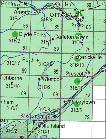 NTS Location Map
To purchase maps contact your local map dealer (see your Yellow Pages) or an on-line service such as World of Maps.
NTS Maps are also available for free on-line (you can save them to your computer and print them out yourself). The best source is the Toporama site run by Natural Resources Canada (the people that make the NTS maps). See: atlas.nrcan.gc.ca/toporama/en/. Read the instructions on that site to find out how you can make your own NTS map set.
Watson's Maps
Yes, I make my own maps for use in my various books and publications. Of interest to the boater are the maps contained in my Paddling Guide to the Rideau Canal. They do not contain hydrographic or topographic information, but are accurately scaled and can be viewed in high detail. They also show a subset of the navigation buoys. And they are free. They are not intended for navigation purposes (the hydrographic charts are the best for that), but can be used for planning and general outings. See the Paddling Guide Page and download the PDF
Ontario Base Maps (OBM)
The Ontario Base Maps are produced by the Ontario Government. These are the most detailed topographic maps (1:10,000) covering all of Ontario. If you plan any off trail hiking or detailed local investigations (by water, road or off-road) - then these are the most detailed topographic maps you can get.
The Ontario government isn't making paper copies of OBM maps anymore but have provided a tool so that you can make your own maps. The tool also allows you to print any maps you create as a PDF. See the Ontario Topographic Maps Page (click on the "Make a Topographic Map Now" link on that page to get started)
Digital Maps
Most of the above maps are now available in digital format for use on your GPS.
Charts - digital versions of the CHS charts of the Rideau are available in either ENC (Electronic Navigational Chart) vector format or BSB raster format (see below for smartphone apps).
NTS Many of these 1:50,000 maps are available as also available as free img files (for any GPS compatible with these) and as PDFs - do an Internet search for "NTS Maps of Canada"
Smartphone Apps - NTS Maps - there are various apps for android or iOS that allow you to use NTS maps. One such is Avenza, available for iOS and Android, which has a free version that allows you to download and use free maps. You can get the "Canada Topo Maps" app for Android from Atlogis Geoinformatics. Both apps allow for the offline use of maps (very handy in Rideau "dead zones"). There are many more apps, too many to cover here.
Smartphone Apps - Navigation Charts - hydrographic chart apps are available for both iOS and Android. For the Rideau, one of the most complete is the Navionics Boating US & Canada app.
On-Line Maps
There are many sites that offer on-line maps. A few are:
Google - Google maps.
Mapquest - Mapquest
Toporama (NTS maps).
Note: what used to a be trickle of on-line map sources has become a flood. It is not the intent of this website to keep up with them all - a search engine query will reveal a host of sources.
Miscellaneous Maps
- For a nice simplified map showing the whole of the Rideau and the locations of all the lockstations, you can't do better than the map in the Parks Canada Rideau Canal brochure. It is available free of charge from all lock stations, most tourist outlets, and the Rideau Canal Office. You can also download or view a PDF file of this brochure (1.8Mb).
- And lastly, there is the Ontario Official Road Map available from most tourist outlets (there may be a slight charge for this map). This map is also available on-line as a series of PDF files. Have a look at: Ministry of Transport's Ontario Map Page
Comments: send me email: Ken Watson
©1996- Ken W. Watson
|