|
Includes Colonel By Lake and River Styx
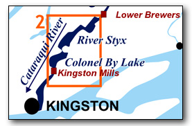
This area bounded by Kingston Mills Lockstation to the south and the head of River Styx to the north. It includes all of Colonel By Lake and River Styx. Both lakes are open and subject to wave action so paddlers, particularly canoeists, should ensure that they do a weather check to make sure the winds are light prior to heading out on these lakes.
No specific route descriptions have been given for paddling the lakes - you should explore these on your own. The map included in this guide can be enlarged (while viewing the PDF) to any level of detail you desire as an aid for travel planning.
You can view or download the PDF file of this guide:
| (Clicking this link will open the PDF. You can also just right mouse click the above link and use "Save Target As" to send the PDF directly to your computer.) |
You can also view a short photo tour video of this area:

Water Access
Colonel By Lake: The lake can be accessed from either Kingston Mills Lockstation (portage from the parking area to take boat(s) to the dock at the head of locks) or the beach or ramp at Rideau Acres Campground (44° 18.440'N - 76° 25.560'W). It is recommended that Rideau Acres Campground be used for those wishing to leave their vehicle overnight.
River Styx: The lake can be assessed from Lower Brewer's Lock (2.6 km / 1.6 mi to the north of River Styx). A short portage from the parking area is required to bring boats to the lower dock.
Facilities
Lodging: If you're paddling and camping, the lockstations are a good choice for camp spots (a camping fee applies). There is also a campground and few B&Bs (Kingston).
Supplies: A local source for supplies is Kingston (full services) or Seeleys Bay (grocery, some hardware).
Big Boats
You'll be sharing the Rideau with big power boats (cruisers). The Rideau is generally not a crowded waterway and often you'll find the large boats in "packs" - travelling from lock to lock - once they pass by you won't see any for awhile. Some of these boats can generate a large wave. The general rule for a paddler and large waves is to meet them head on, this can actually be fun in a kayak (not as much fun in a canoe).
The main navigation channel is shown on the map as a blue dashed line - this is where the big boats will be travelling. So, if you wish to avoid these, pick a route away from the navigation channel. Many paddlers prefer paddling near shore, it's more interesting (i.e. wildlife, cottages) and it keeps you farther away from the waves produced by big boats.
There are several "no wake" zones on the Rideau - these have been marked on the maps. Boaters within these areas are supposed to be travelling at a slow enough speed (less than 10 kph) that their boat doesn't generate any potentially damaging or dangerous waves.
Wind
A question often asked is which way does the wind blow? The prevailing wind, powered by the jet stream, is from the southwest. That's about the only rule of thumb. If a front is moving in then the wind can come from any direction. I've been on several paddles where I've been paddling into the wind on the way out in the morning and into the wind on the way back in the afternoon because the wind swung around 180 degrees (for some reason it never seems to work the other way around - at your back both ways). So, if you're going to travel the entire Rideau, going from Kingston to Ottawa improves the odds of having the wind at your back - but be prepared for anything.
Etiquette
Your trip planning should include a "leave no trace" approach - carry out what you carry in. Many areas are un-serviced (no garbage cans) - so plan to be self-contained. The lockstations provide waste disposal facilities.
Preparation & Safety
Please read the trip planning information on www.rideau-info.com/canal/paddling/. While these lakes are easy paddling, normal paddling preparations should be made (all required safety gear, maps, food, water, first-aid kit, etc.). Zebra mussels are present in many areas along the Rideau, so a pair of water shoes (to avoid cut feet) is recommended.
Please take all normal safety precautions, including checking the weather forecast before you head out and making sure that someone on shore knows your planned travel route and itinerary.
Navigation
While the Rideau is generally easy to navigate, taking along a set of maps is a must (in addition to any GPS you might have). Although the map in this guide is an accurate 1:50,000 representation of the waterway (when printed to 8.5" x 11"), you may also wish to also have the 1:20,000 hydrographic chart for this section (Chart 1513). For power boat navigation, the charts are an absolute must (the map in this guide should not be used for power boat navigation). The charts are also very handy for the paddler, since they show the Rideau in great detail, including depths (which can be helpful when looking for wildlife habitat or just interesting places to paddle).
The charts also show all the navigation buoys. These are all numbered (red buoys have even numbers, green buoys have odd numbers) and so can be used as an aid in locating yourself on the map when you're on open water. A subset of those buoy numbers have been included on the paddling guide maps.
For those wishing to go off the beaten path or want to know more of the topography and geographic features of the surrounding countryside, the 1:50,000 NTS map for this section is 31C/8.
Distances:
Circumference distances are approximate, following the main shorelines & bays. The navigation channel and the scenic routes are shown on the map.
- Kingston Mills to top of River Styx along navigation channel: 13.1 km (8.1 mi)
- Kingston Mills to Lower Brewers Lock along navigation channel: 15.7 km (9.7 mi)
- Colonel By Lake circumference: 22 km (13.7 mi)
- River Styx circumference : 24 km (14.9 mi).
The Lakes
Colonel By Lake
In the pre-canal era this was a meandering section of the Cataraqui River which wound its way to Cataraqui Falls (location of Kingston Mills Lockstation). The damming of the river at Cataraqui Falls with the building of the first mills in 1784 created the initial lake - a mill pond that extended to just south of Caseys Island. The lake was expanded to its current size with the completion of canal dam and extensive berms at Kingston Mills in 1831. This raised the water level at this end of the lake by 26 feet (7.9 m).
The lake is shallow, the deepest point is 25 feet (7.6 m) and the lake averages about 10 to 15 feet (3.0 to 4.6 m). The shallow nature of the lake and the fact that it's at the lower end of the watershed means that it is nutrient loaded, the water normally being green (algae). A potential hazard located outside of the marked navigation channel are stumps (drowned trees), mostly in the northern part of the lake, with the tops just a few inches below the water at normal navigation level. Shallow drafting vessels such as canoes and kayaks will normally not have any problems with these except in times of low water. The green algae in the water make the stumps very hard to see.
The land bordering the lake is privately owned except for the federal lands around the lock. Much of the lake has moderate density cottage and summer home development.
River Styx
Similar to Colonel By Lake, this was a meandering section of the Cataraqui River that was drowned by the raising of the canal dam and berms at Kingston Mills. After the opening of the canal in 1832, this region and Colonel By Lake were collectively known as the "Drowned Lands." The area of River Styx had been a standing forest, the navigation channel was chopped out and the rest of the forest drowned. An 1851 painting shows it as "River Sticks (Styx)" but by the early 20th century is was known solely as River Styx.
It is a very shallow lake, it averages only 7 to 10 feet (2 to 3 m) deep in the navigation channel.
The lands bordering the lake, with the exception of the federal lands of Joyceville Institution (a penitentiary) are privately owned. Most of the lake is surrounded by farmland with a few areas of moderate density cottage/summer home development.
The Locks
Most Rideau lockstations offer facilities such as washrooms, water, recycling cans, waste cans and picnic tables. Most also allow camping for paddlers travelling the Rideau for a modest camping fee. Paddlers can portage the locks for free, but you owe it to yourself to lock through at least one lock in order to get the full experience of paddling the Rideau Canal. See www.rideau-info.com/canal/fees.html for the current fee schedule.
Points of Interest (listed south to north)
Kingston Mills Lockstation: This lockstation features four locks, three in-flight and a detached lock. The total lift is 48.0 feet (14.6 m). The lockmaster’s house (Robert Anglin House) now serves as a visitor’s centre for the locks. The small blockhouse dates to 1832 and is one of only four built along the Rideau. It has been restored to the military period and is sometimes open with an interpreter [closed by Parks Canada in 2012 due to budget cuts].
An interesting configuration at Kingston Mills is the basin formed by the old dam and the new dam. Originally there was just the stone dam with incorporated waste water weir (sitting on the bedrock head of Cataraqui Falls). When it was proposed to add a hydro generating station in 1913, a new concrete dam was built below the stone dam – this formed the basin. The configuration is such that the Rideau Canal (Parks Canada) maintains full control the water flow (via their weir).
Note too the large berms (rebuilt in 2004) to both the east and west of the locks. Originally, two locks were going to be placed farther upstream (at Jack’s Rifts and Billidore’s Rifts), but as with all the lockstations, plans had to be changed to meet conditions. It was decided to put all the locks at Kingston Mills and raised the water from here all the way to Lower Brewers. This meant creating these large embankments (berms) to help impound the water.
The original bridge across the upper lock was a double leaf timber drawbridge built in 1831. It was replaced some time later by a wooden swing bridge (easier to use than a drawbridge). In 1956 a steel through plate girder swing bridge was installed. That bridge was replaced by another steel swing bridge in 1988. This bridge was rehabilitation in the fall/winter of 2016-17.
The first bridge at Kingston Mills was a fixed timber bridge, placed across Cataraqui Falls, when the Kingston-Montreal road was completed in about 1801. In 1909 a steel bridge was built to replace the previous wooden structure. This fixed bridge was replaced during the fall/winter of 2016/17.
The railway bridge that crosses the locks was first constructed by the Grand Trunk Railroad as a wooden bridge in 1855. In 1890 it was rebuilt as a steel bridge with a double track and in 1924 the pier stands were rebuilt with concrete. It is presently owned and used by the CNR.
The locks bypass Cataraqui Falls of which only the lower portion is visible today (the canal dam is built on the head of the falls). A native portage used to lead around the falls. These falls, which originally had a drop of about 20 feet (6.1 m), were the site of the first mills in the area, the King's Mills, built in 1784. A succession of both timber mills (1794-1863) and grist mills (1794-1904) were built and used here.
Colonel By Lake: The west side of this man-made lake is mostly undeveloped (farm frontage) while the east side has cottage and summer home development - so you'll find the best wildlife viewing opportunities along the west shoreline. The foot of the channel at the head of the lake (Harriet Point) is the location of Jack's Rifts - a small set of rapids (now drowned) where a lock was originally proposed.
Colonel By Lake Stumps: If you're off the navigation channel in the northern part of the lake, you may notice some stumps sitting a few inches underwater. These are what is left of the forests of the region, which were drowned when the water was raised with the building of the locks, dam and embankments at Kingston Mills. These are still rooted trees, if you're carrying the navigation charts you'll be able to see how tall these are (if you see a stump in 20 feet of water, you're looking at the top of a 20 foot tree trunk).
When the Rideau Canal was built, Colonel By had a wide (about 60 m / 200 ft) swath cut through the existing forest in the vicinity of the Cataraqui River between Kingston Mills and Upper Brewers before the area was flooded. This cut path followed a much straighter line than the meandering river and this is what today's buoyed navigation way represents. Canal era maps show this cleared route in relation to the original meandering river. The forests on either side of this cleared channel were simply drowned.
Most of these and other stumps that you will see in standing water on the Rideau Canal date to about 1831, when the canal dams were completed and the area above those dams flooded. If the tree was 100 years old when flooded, then you're looking at a tree stump that started off as a sapling in 1731.
In the case of Colonel By Lake, the original mill dam (for the King's Mills and subsequent timber and grist mills) flooded the Cataraqui River and surrounding forest up to the area of Caseys Island, starting in 1784. So, some of the stumps in that area may date back to that time. Originally they were full size dead trees. A few were cut but most have simply been broken or rotted off at the ice line.
A painting showing River Styx in 1844 shows a forest of dead standing timber, many with either an Osprey or Great Blue Heron's nest near the top. Herons in particular prefer to make a nest at the top of a dead standing tree, there are still heron rookeries (nesting areas) today in swampy areas with dead trees bordering the Rideau Canal.
Jack's Rifts: The foot of the channel between River Styx and Colonel By Lake (Harriet Point) is the location of Jack's Rifts - a small set of rapids where a lock was originally proposed. These rapids were drowned by the water raised by the canal dam and berms at Kingston Mills.
River Styx: Much of the shoreline of this man-made lake is undeveloped (farm frontage). Keep your eye out for Green Herons, a colourful smaller member of the heron family. As with Colonel By Lake, you may see stumps off the navigation channel, remains of the drowned forest, and the reason for the original name of the lake as River Sticks.
As noted in the Colonel By Lake writeup, the buoyed channel doesn't directly follow the original channel of the Cataraqui River, which was more of a meandering creek. As of this writing, the present navigation channel and old meandering creek channel can be seen in satellite photos (i.e. Google Earth) at the head of River Styx.
Joyceville Institution: This is a medium-security penitentiary.
Billidore's Rifts: The head of River Styx marks the location of Billidore's Rifts, a small set of rapids where a lock was originally proposed. These rapids were drowned by the water raised by the canal dam and berms at Kingston Mills.
Cataraqui River: The Cataraqui River is a deeper, straighter river than the original meandering creek. Much of today's navigation way was cut through the pre-canal forests (to straighten the route). But you can still spot some of the meanders of the original creek.
Just south of Lower Brewers, you'll find some apple trees growing on the banks of the river (presumably grown from seeds blown from the apple orchard located near Lower Brewers). So, if you're paddling that area in September and want a snack, you may find some nice apples within picking range from your boat.
Route Suggestions
No specific route suggestions have been provided.- These lakes are most interesting for shoreline putterings.
Geology
As you paddle the Rideau Canal, the route you follow is defined by its geology. Geological highlights have been included in the Points of Interest listings and a general geological history of the route can be found on the Geology of the Rideau Page.
Wildlife Viewing
A section about wildlife viewing, what you might expect to see on your Rideau journey, has been included in text form in the PDF. A version of this information, that includes photos of some typical Rideau wildlife, can be found on the Fauna of the Rideau Page (in the ecology section of this website).
Errors
If you find any errors or omissions in this guide, please let me know (rideauken@gmail.com) and I'll get them fixed.
Terms of use
This guide may be freely used for personal purposes. Have fun on your Rideau paddling adventure.
Commercial use is not allowed in whole or in part without express written permission.
©2010- Ken W. Watson, All Rights Reserved.
You can view or download the PDF file:
| (Clicking this link will open the PDF. You can also just right mouse click the above link and use "Save Target As" to send the PDF directly to your computer.) |
|