|
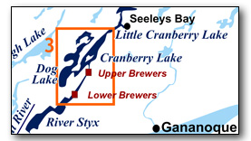
Includes Cataraqui River, Cranberry Lake and Dog Lake
This area bounded by the top end of River Styx to the south and Brass Point Bridge (top of Cranberry Lake) to the north. It includes part of the Cataraqui River, Cranberry Lake and Dog Lake. The area provides great day paddling experiences. In most areas, the winding shorelines and islands provide shelter and so can be paddled even when the wind is up. The map included in this guide can be enlarged (while viewing the PDF) to any level of detail you desire.
No specific route descriptions have been given for paddling the lakes - you should explore these on your own. The detailed map in this guide will allow for travel planning.
| (Clicking this link will open the PDF. You can also just right mouse click the above link and use "Save Target As" to send the PDF directly to your computer.) |
You can also view short photo tour videos of this area:

Water Access
Cranberry Lake: The easiest point of access is Upper Brewers Lockstation which has lots of parking and a small gravel ramp. You can also paddle down to the lake from the ramp at Seeleys Bay (see Rideau Paddling Guide 3)
Dog Lake: As with Cranberry Lake, it can be accessed from Upper Brewers Lockstation. You can access the west side from a public ramp on Gilmore Point (44° 25.950'N - 76° 21.540'W).
Facilities
Lodging: If you're paddling and camping, the lockstations are a good choice for camp spots (a camping fee applies). There are also several campgrounds and few B&Bs. For information about local accommodations see: www.rideau-info.com (this website).
Supplies: A local source for supplies is the village of Elgin (off Hwy. 15 opposite Davis Lock Road), which has a grocery store, pharmacy and hardware store. Supplies (grocery, some hardware) can also be obtained in the village of Seeleys Bay.
Big Boats
You'll be sharing the Rideau with big power boats (cruisers). The Rideau is generally not a crowded waterway and often you'll find the large boats in "packs" - travelling from lock to lock - once they pass by you won't see any for awhile. Some of these boats can generate a large wave. The general rule for a paddler and large waves is to meet them head on, this can actually be fun in a kayak (not as much fun in a canoe).
The main navigation channel is shown on the map as a blue dashed line - this is where the big boats will be travelling. So, if you wish to avoid these, pick a route away from the navigation channel. Many paddlers prefer paddling near shore, it's more interesting (i.e. wildlife, cottages) and it keeps you farther away from the waves produced by big boats.
There are several "no wake" zones on the Rideau - these have been marked on the maps. Boaters within these areas are supposed to be travelling at a slow enough speed (less than 10 kph) that their boat doesn't generate any potentially damaging or dangerous waves.
Wind
A question often asked is which way does the wind blow? The prevailing wind, powered by the jet stream, is from the southwest. That's about the only rule of thumb. If a front is moving in then the wind can come from any direction. I've been on several paddles where I've been paddling into the wind on the way out in the morning and into the wind on the way back in the afternoon because the wind swung around 180 degrees (for some reason it never seems to work the other way around - at your back both ways). So, if you're going to travel the entire Rideau, going from Kingston to Ottawa improves the odds of having the wind at your back - but be prepared for anything.
Etiquette
Your trip planning should include a "leave no trace" approach - carry out what you carry in. Many areas are un-serviced (no garbage cans) - so plan to be self-contained. The lockstations provide waste disposal facilities.
Preparation & Safety
Please read the trip planning information on www.rideau-info.com/canal/paddling/. While these lakes are easy paddling, normal paddling preparations should be made (all required safety gear, maps, food, water, first-aid kit, etc.). Zebra mussels are present in many areas along the Rideau, so a pair of water shoes (to avoid cut feet) is recommended.
Please take all normal safety precautions, including checking the weather forecast before you head out and making sure that someone on shore knows your planned travel route and itinerary.
Navigation
While the Rideau is generally easy to navigate, taking along a set of maps is a must (in addition to any GPS you might have). Although the map in this guide is an accurate 1:50,000 representation of the waterway (when printed to 8.5" x 11"), you may also wish to also have the 1:20,000 hydrographic chart for this section (Chart 1513). For power boat navigation, the charts are an absolute must (the map in this guide should not be used for power boat navigation). The charts are also very handy for the paddler, since they show the Rideau in great detail, including depths (which can be helpful when looking for wildlife habitat or just interesting places to paddle).
The charts also show all the navigation buoys. These are all numbered (red buoys have even numbers, green buoys have odd numbers) and so can be used as an aid in locating yourself on the map when you're on open water. A subset of those buoy numbers have been included on the paddling guide maps.
For those wishing to go off the beaten path or want to know more of the topography and geographic features of the surrounding countryside, the 1:50,000 NTS map for this section is 31C/8.
Distances:
Circumference distances are approximate, following the main shorelines & bays. The navigation channel and the scenic routes are shown on the map.
- Top of River Styx to Lower Brewers along navigation channel: 2.6 km (1.6 mi)
- Lower Brewers to Upper Brewers along navigation channel: 2.8 km (1.7 mi)
- Upper Brewers to Brass Point Bridge along navigation channel: 6.5 km (4.0 mi)
- Cranberry Lake Circumference (main shorelines): 33 km (20.5 mi)
(entire lake: Fiddlers Elbow to Brass Point Bridge)
- Dog Lake Circumference: 55 km (34.2 mi).
(South Dog = 22.5 km, Long Reach = 8 km, North Dog = 24.5 km)
The Lakes
Cataraqui River
This section, from the head of River Styx to the Round Tail, is a flooded remnant of part of the original Cataraqui River. The meandering nature of the original creek is obscured today due to channel straightening carried out during the building of the canal. Water levels are also elevated due to the canal dams at Kingston Mills, Lower Brewers and Upper Brewers. The land bordering the river is privately owned, the exception being federal lands in the vicinity of the locks.
Cranberry Lake
In the pre-canal era this was a very small lake (the area north of Beaupre Island bounded by the west shore, Big Island and Track Island). It was greatly expanded by the flooding caused by the canal dam at Upper Brewers lockstation (water impounded in conjunction with the canal dam at Morton). The deepest part of the lake at 17 feet (5.2 m) in the original lake section, the rest of the lake averages about 10 feet (3 m) in depth.
In the pre-canal era, the area from the Round Tail (just north of Upper Brewers Locks) to Deans Island (in the north end of Whitefish Lake - see Map 4), was the Cranberry Flood Plain. It was above water in the summer (non-navigable). This former flood plain, filled with sediment to form an almost flat bed, provides a contrast of high steep cliffs (particularly on the western shore) plunging into shallow water, not the deep water that the topography would imply.
The land bordering the lake is privately owned (the exception being the federally owned Beaupre Island, the southern section of which is leased to a private owner). Much of the lake has moderate density cottage and summer home development.
Dog Lake
This is really two different lakes. The north end is an original pre-canal lake while the south end is a man-made lake, a result of the flooding from the dams at Upper Brewers and Morton. The lake also differs greatly in depth from north to south.
The north end of the lake is very deep with a maximum depth of 167 feet (51 m). It averages about 50 feet (15 m) deep. It hosts typical Rideau warm-water species of fish (largemouth bass, smallmouth bass, northern pike and crappie). The deeper part of the lake used to host lake trout but they have disappeared due to overfishing and development. It is a typical Canadian Shield lake, with some beautiful rocky exposures.
In the pre-canal era, the man-made south end of Dog Lake was the upper reaches of the Cataraqui River (or creek) which flowed through this area from its headwater in Loughborough Lake (now Milburn Creek).
The land bordering the lake is privately owned. Much of the lake has moderate density cottage and summer home development.
The Locks
Most Rideau lockstations offer facilities such as washrooms, water, recycling cans, waste cans and picnic tables. Most also allow camping for paddlers travelling the Rideau for a modest camping fee. Paddlers can portage the locks for free, but you owe it to yourself to lock through at least one lock in order to get the full experience of paddling the Rideau Canal. See www.rideau-info.com/canal/fees.html for the current fee schedule.
Points of Interest (listed south to north)
River Styx: Much of the shoreline of this man-made lake is undeveloped (farm frontage). Keep your eye out for Green Herons, a colourful smaller member of the heron family. As with Colonel By Lake, you may see stumps off the navigation channel, remains of the drowned forest, and the reason for the original name of the lake as River Sticks.
As noted in the Colonel By Lake writeup, the buoyed channel doesn't directly follow the original channel of the Cataraqui River, which was more of a meandering creek. As of this writing, the present navigation channel and old meandering creek channel can be seen in satellite photos (i.e. Google Earth) at the head of River Styx.
Joyceville Institution: This is a medium-security federal penitentiary.
Billidore's Rifts: The head of River Styx marks the location of Billidore's Rifts, a small set of rapids where a lock was originally proposed. These rapids were drowned by the water raised by the canal dam and berms at Kingston Mills.
Cataraqui River: The Cataraqui River is a deeper, straighter river than the original meandering creek. Much of today's navigation way was cut through the pre-canal forests (to straighten the route). But you can still spot some of the meanders of the original creek.
Just south of Lower Brewers, you'll find some apple trees growing on the banks of the river (presumably grown from seeds blown from the apple orchard located near Lower Brewers). So, if you're paddling that area in September and want a snack, you may find some nice apples within picking range from your boat.
Lower Brewers Lock: This is a single lock with a lift of 4.0 m / 13.3 feet. A feature of this lockstation is the unequal arm, center bearing timber swing bridge, one of only four remaining on the Rideau. It also has a defensible lockmaster's house, originally a one storey stone building, built in the early 1840s. The second wooden storey was added in about 1899. A grain storage elevator located adjacent to the bywash was built in about 1865. The hydro generating station at this site was erected in 1942.
Sunbury Road Bridge: This fixed high level (6.7 m /22.0 ft) bridge was built in 1967. It carries Country Road 12 over the canal. Prior to this bridge, Country Road 12 went across a timber swing bridge over Lock 44 (the first swing bridge over the lock was installed in 1850) and a low level fixed bridge (still existing) over the Cataraqui River.
Upper Brewers Locks: There is a set of two locks with a lift of 5.9 m / 19.5 feet. The locks were constructed to the west side of the Cataraqui River in order to bypass the mills at this location and leave them intact. A man-made cut leads to the basin (formed by two embankments) above the locks. The defensible lockmaster's house on the top of the knoll was built in 1842 (today leased to a private owner). The hydro generating station below the dam was erected in 1939.
The Ark: On the west side of the Upper Brewers' basin, hidden behind cedar trees is a large houseboat (now a private residence) known as "The Ark." The original name for this houseboat was the "Wenona" and it was originally owned by Otto Rohr of Rochester, N.Y. It was towed to this location sometime between 1900 and 1915 (it shows up in a 1915 air photo of Lower Brewers).
Upper Brewers Canal Cut: The canal, from the basin to the dam, is an artificial cut. If you look closely at the vertical rock face on the east side of the cut, you'll see some half round vertical indentations, there are the inner half of drill holes (hand driven) used for blasting out the rock in the cut. Also, about halfway along the cut was the location of a safety gate designed by Colonel By. It was a gate that lay flat on the floor of the channel, which could be raised in the event of flood waters. The gate was placed there since a flood did occur in 1832 when a private miller's dam on Loughborough Lake (at today's Battersea) broke and almost flooded out the lock (this story is told in Tales of the Rideau). The gate was removed in 1847.
The Duke's Profile: Just south of The Round Tail is “The Court of the Duke” and on the east side there is a rock outcrop that juts out over the water, named the “Duke’s Profile” for the Duke of Wellington, the Iron Duke – the man who was responsible for initiating the project to build the Rideau Canal. This name dates back to the building of the canal. The Duke of Wellington had a rather prominent nose and this outcrop reminded those working on the Rideau of the duke in profile. The profile can be viewed either way, often most evident when the water is at or below normal navigation level.
The Round Tail: This rocky constriction had a profound impact on the Rideau Canal. Prior to the early 1800s, if you were paddling north through here, you would make almost a 90 degree turn left (west) to follow the Cataraqui River up to its headwater, Loughborough Lake. To get back to the Rideau you would go from the northern exit of Loughborough Lake to Hart Lake and then to Opinicon Lake. You couldn't continue north by canoe, it was semi-dry land (a flood plain). But, sometime after 1805 and prior to 1816, brothers Lemuel and Carey Haskins erected a mill dam here in order to increase the head of water for their mill at Whitefish Falls (Morton). This put about 6 feet (2 m) of water over the flood plain, making it navigable. This "navigation by flooding" so impressed surveyor Samuel Clowes in 1824/25 that instead of proposing a conventional canal (canal cuts) such as he did for the rest of the Rideau, he proposed converting these mill dams (Round Tail and Morton) into canal dams to create a navigation way - a slackwater system. Colonel By ended up doing the entire Rideau as a slackwater system. Did the idea to make the Rideau Canal a slackwater system originate right here at the Round Tail? Something to think about (as you enjoy easy slackwater paddling).
Also of note, is that the marked navigation channel in this location is an artificial cut. The west (non-navigation channel) opening is the original, now drowned channel of the Cataraqui River.
Also of note, is that the marked navigation channel in this location is an artificial cut. The west (non navigation channel) opening is the original, now drowned channel of the Cataraqui River.
Dog Lake: The north end of the lake features typical shield terrain, pine trees and rocky exposures with deep clear water. The south end of the lake is a typical shallow water lake (created by the flooding caused by the canal dam at Upper Brewers Locks), a mix of marshy and rocky shorelines. There are many interesting cottages on the lake.
Carrying Place: Although the trail is not visible today, the narrow neck of land between Dog Lake and Cranberry Lake (directly west of the south tip of Beaupre Island) was a native portage route between Cranberry Marsh and the original pre-canal Dog Lake, which, due to its depth, offered fishing for Lake Trout (the trout were gone by the 1980s due to overfishing).
Cranberry Lake: An expansive lake created by flooding by the canal dam at Upper Brewers, it has some interesting undeveloped shorelines and cottage development. Note the restoration of a lovely old cottage at the south end of Beaupre Island.
Brass Point Bridge: You can't miss this - a long and narrow steel bridge with wooden decking which incorporates a wooden swing bridge (an unequal arm, center bearing timber swing bridge, one of only four remaining on the Rideau) at the west end. The swing bridge is operated by Parks Canada. This long (148 m / 485 ft) bridge was originally built in 1887. The wooden spans were replaced with steel spans in 1903 and new cribbing was installed in 1978. Paddlers can easily pass under the bridge.
This is the only remaining bridge of this type (multi-span with a swing bridge) on the Rideau Canal. There used to be similar bridges at places such as Rideau Ferry, Becketts Landing, Kars and Manotick - those have all been replaced by high level bridges.
Route Suggestions
No specific route suggestions have been provided - but Dog and Cranberry lakes do provide some nice day paddling experiences. The size of the lakes is such that, depending on your launch point and paddling speed, they can make three nice day trips - one doing Cranberry Lake, one doing the north half of Dog Lake and one doing the south half of Dog Lake. I tend to always launch from Upper Brewers since it provides an easy launch point and lots of parking.
Geology
As you paddle the Rideau Canal, the route you follow is defined by its geology. Geological highlights have been included in the Points of Interest listings and a general geological history of the route can be found on the Geology of the Rideau Page.
Wildlife Viewing
A section about wildlife viewing, what you might expect to see on your Rideau journey, has been included in text form in the PDF. A version of this information, that includes photos of some typical Rideau wildlife, can be found on the Fauna of the Rideau Page (in the ecology section of this website).
Errors
If you find any errors or omissions in this guide, please let me know (rideauken@gmail.com) and I'll get them fixed.
Terms of use
This guide may be freely used for personal purposes. Have fun on your Rideau paddling adventure.
Commercial use is not allowed in whole or in part without express written permission.
©2010- Ken W. Watson, All Rights Reserved.
You can view or download the PDF file:
| (Clicking this link will open the PDF. You can also just right mouse click the above link and use "Save Target As" to send the PDF directly to your computer.) |
|