|
Includes Little Cranberry Lake, Whitefish Lake and Morton Bay
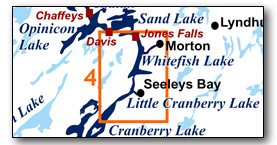
This area bounded by the middle of Cranberry Lake at the south end and Jones Falls lockstation at the north end. It includes Whitefish lake, Little Cranberry Lake, Morton Bay and part of Cranberry Lake. The area provides great day paddling experiences. The area features narrow sections and winding shorelines and so can be paddled even when the wind is up. The map included in this guide can be enlarged (while viewing the PDF) to any level of detail you desire.
No specific route descriptions have been given for paddling the lakes - you should explore these on your own. The detailed map in this guide will allow for travel planning. However, for those just paddling through the lakes (going lock to lock), a scenic route has been suggested.
You can view or download the PDF file:
| (Clicking this link will open the PDF. You can also just right mouse click the above link and use "Save Target As" to send the PDF directly to your computer.) |
You can also view a short photo tour video of this area:

Water Access
Whitefish Lake: There are two options in Seeley's Bay - one is the Paddling Station in Centennial Park (accessed via Haskins Point Road) which has a paddling dock (44° 28.695'N - 76° 14.290'W). The other is the launch ramp and public docks (44° 28.730'N - 76° 14.210'W). Near Morton there is a public dock and a paddling dock (Parks Canada) with a small parking lot by the dam at the end of Morton Bay (at 44° 32.210'N - 76° 12.250'W, accessed by road from Morton). You can also launch from the Shangri-La Cottages & Campground (at Jones Falls) for a fee. There are also campgrounds on Cranberry Lake that provide access to the water.
Cranberry Lake: The easiest point of access is Upper Brewers Lockstation (see Rideau Paddling Guide 3) which has lots of parking and a small gravel ramp.
Facilities
Lodging: If you're paddling and camping, the lockstations are a good choice for camp spots (a camping fee applies). There are also several campgrounds, a host of B&Bs and a hotel (Hotel Kenney at Jones Falls) and a lodge (Shangri-La at Jones Falls). For information about local accommodations see: www.rideau-info.com (this website).
Supplies: A local source for supplies is the village of Elgin (off Hwy. 15 opposite Davis Lock Road), which has a grocery store, pharmacy and hardware store. Supplies (grocery, some hardware) can also be obtained in the village of Seeleys Bay.
Big Boats
You'll be sharing the Rideau with big power boats (cruisers). The Rideau is generally not a crowded waterway and often you'll find the large boats in "packs" - travelling from lock to lock - once they pass by you won't see any for awhile. Some of these boats can generate a large wave. The general rule for a paddler and large waves is to meet them head on, this can actually be fun in a kayak (not as much fun in a canoe).
The main navigation channel is shown on the map as a blue dashed line - this is where the big boats will be travelling. So, if you wish to avoid these, pick a route away from the navigation channel. Many paddlers prefer paddling near shore, it's more interesting (i.e. wildlife, cottages) and it keeps you farther away from the waves produced by big boats.
There are several "no wake" zones on the Rideau - these have been marked on the maps. Boaters within these areas are supposed to be travelling at a slow enough speed (less than 10 kph) that their boat doesn't generate any potentially damaging or dangerous waves.
Wind
A question often asked is which way does the wind blow. The prevailing wind, powered by the jet stream, is from the southwest. That's about the only rule of thumb. If a front is moving in then the wind can come from any direction. I've been on several paddles where I've been paddling into the wind on the way out in the morning and into the wind on the way back in the afternoon because the wind swung around 180 degrees (for some reason it never seems to work the other way around - at your back both ways). So, if you're going to travel the entire Rideau, going from Kingston to Ottawa improves the odds of having the wind at your back - but be prepared for anything.
Etiquette
Your trip planning should include a "leave no trace" approach - carry out what you carry in. Many areas are un-serviced (no garbage cans) - so plan to be self-contained. The lockstations provide waste disposal facilities.
Preparation & Safety
Please read the trip planning information on www.rideau-info.com/canal/paddling/. While these lakes are easy paddling, normal paddling preparations should be made (all required safety gear, maps, food, water, first-aid kit, etc.). Zebra mussels are present in many areas along the Rideau, so a pair of water shoes (to avoid cut feet) is recommended.
Please take all normal safety precautions, including checking the weather forecast before you head out and making sure that someone on shore knows your planned travel route and itinerary.
Navigation
While the Rideau is generally easy to navigate, taking along a set of maps is a must (in addition to any GPS you might have). Although the map in this guide is an accurate 1:50,000 representation of the waterway (when printed to 8.5" x 11"), you may also wish to also have the 1:20,000 hydrographic chart for this section (Chart 1513). For power boat navigation, the charts are an absolute must (the map in this guide should not be used for power boat navigation). The charts are also very handy for the paddler, since they show the Rideau in great detail, including depths (which can be helpful when looking for wildlife habitat or just interesting places to paddle).
The charts also show all the navigation buoys. These are all numbered (red buoys have even numbers, green buoys have odd numbers) and so can be used as an aid in locating yourself on the map when you're on open water. A subset of those buoy numbers have been included on the paddling guide maps.
For those wishing to go off the beaten path or want to know more of the topography and geographic features of the surrounding countryside, the 1:50,000 NTS maps for this section are 31C/8 and 31C/9.
Distances:
Circumference distances are approximate, following the main shorelines. The navigation channel and the scenic route are shown on the map.
- Upper Brewers to Brass Point Bridge along navigation channel: 6.5 km (4.0 mi)
- Brass Point Bridge to Jones Falls along navigation channel: 10.8 km (6.7 mi)
- Scenic Route from navigation channel to Seeleys Bay (return): 1.7 km (1.0 mi)
- Scenic Route from navigation channel into Morton Bay (return): 7.0 km (4.3 mi)
- Whitefish Lake Circumference (main shorelines): 28 km (17.4 mi)
- Little Cranberry Lake Circumference (main shorelines): 21 km (13.0 mi)
- Cranberry Lake Circumference (main shorelines): 33 km (20.5 mi)
(entire lake: Fiddlers Elbow to Brass Point Bridge)
The Lakes
Cranberry Lake
In the pre-canal era this was a very small lake (the area north of Beaupre Island bounded by the west shore, Big Island and Track Island). It was greatly expanded by the flooding caused by the canal dam at Upper Brewers lockstation (water impounded in conjunction with the canal dam at Morton). The deepest part of the lake at 17 feet (5.2 m) in the original lake section, the rest of the lake averages about 10 feet (3 m) in depth.
In the pre-canal era, the area from the Round Tail (just north of Upper Brewers Locks - see Map 3) to Deans Island (in the north end of Whitefish Lake), was the Cranberry Flood Plain. It was above water in the summer (non-navigable). This former flood plain, filled with sediment to form an almost flat bed, provides a contrast of high steep cliffs (particularly on the western shore) plunging into shallow water, not the deep water that the topography would imply.
The land bordering the lake is privately owned (the exception being the federally owned Beaupre Island, the southern section of which is leased to a private owner). Much of the lake has moderate density cottage and summer home development.
Little Cranberry Lake
This is a man-made lake - in the pre-canal era it was part of the Cranberry Flood Plain, an area of forest, streams, ponds and marshes. The lake was created by the canal dams at Upper Brewers and at Morton. The water depth in the lake (near the navigation channel) averages about 9 feet (2.7 m).
Whitefish Lake
This is a man-made lake - in the pre-canal era the northern part of the lake was the White Fish River and the southern part was the northern end of the Cranberry Flood Plain. Prior to the lake being created by the flooding from the dams at Upper Brewers and Morton, the Jones Falls Rapids marked the start of the White Fish River which flowed past Hog Island, around the south end of Deans Island, through Morton Bay and over White Fish Falls (location of the dam today) before continuing to Lower Beverley Lake and eventually to the St. Lawrence River at Gananoque. The southern part of the lake was a forest of ash trees which only saw water in times of spring flood.
The depth of the lake itself averages about 9 feet (2.7 m).
Morton Bay
Dominated by the large granite exposures of Rock Dunder and Dunders Mate (part of the Lyndhurst Pluton) on the west side of the Bay, this was a deep gorge with water levels 20 to 25 feet ( 7.5 m) lower than they are today. The White Fish River ran through here on its way to White Fish Falls (site of today's canal dam). Today this is a beautiful deep water bay.
The Locks
Most Rideau lockstations offer facilities such as washrooms, water, recycling cans, waste cans and picnic tables. Most also allow camping for paddlers travelling the Rideau for a modest camping fee. Paddlers can portage the locks for free, but you owe it to yourself to lock through at least one lock in order to get the full experience of paddling the Rideau Canal. See www.rideau-info.com/canal/fees.html for the current fee schedule.
Points of Interest (listed south to north)
Cranberry Lake: an expansive lake with interesting natural shorelines and cottage development.
Brass Point Bridge: You can't miss this - a long and narrow steel bridge with wooden decking which incorporates a wooden swing bridge (an unequal arm, center bearing timber swing bridge, one of only four remaining on the Rideau) at the west end. The swing bridge is operated by Parks Canada. This long (148 m / 485 ft) bridge was originally built in 1887. The wooden spans were replaced with steel spans in 1903 and new cribbing was installed in 1978. Paddlers can easily pass under the bridge.
This is the only remaining bridge of this type (multi-span with a swing bridge) on the Rideau Canal. There used to be similar bridges at places such as Rideau Ferry, Becketts Landing, Kars and Manotick - those have all been replaced by high level bridges.
Little Cranberry Lake: This is a narrow section connecting Whitefish Lake with Cranberry Lake. There are a number of nooks and crannies that harbour wildlife, so it is worth staying off the navigation channel and paddling along the shorelines.
Haskins Point: This spot is named after Samuel Haskin who purchased the point in 1840 and set up commercial wharves to serve steamboat traffic. It was also known for a time as Ferry Point with a ferry service (small hand operated ferry) operating between the point and Hewitt Island, from the late 1880s to 1996.
Seeleys Bay: A lovely little village - there are extensive public docks and a ramp, plus a paddling station. The paddling station, located just south of the public docks (in Centennial Park, off of Haskins Point Road), features a paddling dock, two large racks that will hold 4 canoes or kayaks each and four large and lock-able stow bins that are big enough for paddles, life jackets and lots of gear. There is also a map and information sign to point people to the nearby public toilets and showers, and info about services in Seeleys Bay.
Although the flooding of the Cranberry Flood Plain in 1832 created the bay we see today, it wasn't until the mid-1800s that the removal of stumps and floating marshes in the bay allowed the village to flourish. It became a regular stop for steamers plying between Kingston and Ottawa.
Whitefish Lake: the west side of the lakes features some interesting topography - hills and cliffs. Also lots of interesting looking cottages along both shorelines.
Indigenous Paddling Route: Today we can easily paddle from Kingston to Jones Falls, but in the pre-dam era this couldn't be done. The area from the Round Tail to near the channel entrance to Morton Bay (i.e. part of Cranberry Lake, Little Cranberry Lake and part of Whitefish Lake) was above water. It was a flood plain dominated by forests made up mainly of ash trees, marshy areas, streams and ponds. The main native paddling route to get from the Ottawa River to the St. Lawrence River was via the White Fish River, which had its headwaters in Sand Lake and flowed through today's Morton Bay on its way to the Gananoque River. So, today, if you head into Morton Bay, you'll be floating over part of an original native paddling route (much changed now due to dams and flooding).
Morton Bay: This sheltered bay is a very pretty area dominated by large granite outcrops; Rock Dunder and Dunders Mate (part of the Lyndhurst Pluton). Much of the land in the vicinity of Rock Dunder is owned by the Rideau Waterway Land Trust and a trail leads to the top. The trail is a bit hard to access from the water - look for a good landing spot between the peak of Rock Dunder and Floods Island and head uphill until you intersect the trail (see the exact location of the trail on Map 4).
In the pre-dam era (before 1803), the water level was 23 ft / 7 m lower that it is today - it was a river running through a rocky gorge. The scenery is impressive today, it would have been even more impressive before the water level was raised.
Morton Dam: Easy access to the dam is provided by a public dock maintained by Parks Canada at the head of Morton Bay. The dam is near the location of the original mill dam at White Fish Falls, erected by Lemuel and Carey Haskins in about 1803. Haskins' dam blocked the flow of the original White Fish River (the western part of which is now known as Morton Creek), which drained the southern Rideau lakes (Newboro, Clear, Indian, Opinicon, Sand) to the Gananoque River (via Lower Beverley Lake).
Prior to the dam being put in place, this was the main native paddling route from the St. Lawrence River (at Gananoque) to the Ottawa River (at Rideau Falls) since there was no water connection to the Cataraqui River. The original 1803 mill dam, and now the canal dam, stopped the flow to the Gananoque River and diverted it to the Cataraqui River. It is this dam, together with the dam at Upper Brewers, that made the area between Deans Island and Upper Brewers navigable (flooding the Cranberry Flood Plain, the area now occupied by parts of Cranberry, Little Cranberry and Whitefish lakes). The concrete dam that can be seen today was built in 1919 and substantially rebuilt in 1982.
On the north side of the dam, you'll find a trail leading to the top of the cliffs. A wooden guardhouse was built here in 1838 in response to the Upper Canada Rebellion. It deteriorated and was torn down in 1929. Today, a walk to the top provides a fine view.
Morton Creek Portage Road: Those interested in a bit of milling history will wish to follow the old road on the south side of the creek (from the parking lot above the dam). About 325 m / 1,075 ft down that road you'll find the remains of George Morton's mill site, originally established in the late 1850s. He had to sell his mills in the 1870s. They burned down in about 1886, but were rebuilt. Today only the foundations remain. In the 1880s, plans were drawn up to put two locks in this location, part of a scheme to make a navigable waterway connecting the Rideau Canal to Gananoque on the St. Lawrence River. It never got off the ground. If you follow this road for another 235 m / 775 ft you'll end up at Highway 15 where there is a launch point into Morton Creek (allowing you to paddle all the way to Gananoque).
Jones Falls Lockstation: This is one of the prettiest lockstations on the entire Rideau. It consists of an upper lock, a turning basin and a flight of three locks (total lift of 17.3 m / 56.9 ft). At the foot of the locks is the historic Hotel Kenney (also a snack bar - offering tasty treats). The link from the hotel to the locks is over a wooden bridge, originally built in 1883. This was part of a roadway that led to a swing bridge over the middle lock. Today only the abutments for that swing bridge remain.
You'll find a small visitor centre (with washrooms) near the top of the combined locks. The road leads from there to the upper lock. As you walk up that road and look down, you'll see an old road angling down to Jones Falls Bay. This is part of the original haul road for the stones (sandstone) used in the building of the locks, which were brought by wagon from a quarry near Elgin, 10 km (6 mi) away.
Just below and to the west of the upper lock is a blacksmith's shop built in the 1840s. It sometimes has a blacksmith in attendance.
Above the upper lock is a defensible lockmaster's house (a stone building with gun slits, built in the 1840s), usually open during the summer with an interpreter. It is known as Sweeney House, after the first lockmaster, Peter Sweeney (a diary that he kept while living there with his family is available in book form as The Sweeney Diary).
Between Sweeney House and the dam you'll find the waste water weir, blasted (using black powder) through a bedrock ridge (you can still see the remains of some of the hand-drilled blast holes). The present weir was rebuilt in 2011. The water flows through this weir to form Redpath Falls, named after the contractor who built the locks and dam, John Redpath.
A walking trail exist around the west side of the basin (from the Lockstation House to the Blacksmith's Shop).
At the time of the building of the Rideau Canal, the locks at Jones Falls featured the greatest lift (15 ft / 4.6 m each) and consequently the tallest lock gates of any lockstation. There was some worry about the size of the gates, whether they could stand up to the water pressure. They served well, being replaced with new gates on a regular basis (every 20 years or so). However, in 1869, the gates between Lock 40 and 41 apparently failed, allowing one barge to crash into another. Two men were killed. As it turns out, the failure of the gates was a result of the accident, not the cause, and that full story is related in Tales of the Rideau. No gate has failed since that time.
Jones Falls Dam: The most impressive feature at Jones Falls is the Great Stone Arch Dam - the largest dam built during the construction of the Rideau Canal. It is 107 m (350 ft) wide at the top (following the arch) and 30.5 m (100 ft) wide at ground level. The height of the stonework from its base (buried 1.8 m (6 ft) below surface) is 17.4 m (57 ft) and an earthen berm adds about another 1.2 m (4 ft), making the dam about 18.6 m (61 ft) high. It is known as the "whispering dam" since a person standing at one end, talking in regular conversational tone, can be heard by someone at the other end of the dam - the face of the dam providing a reflecting surface for sound.
The dam is located in the bed of the original Jones Falls Rapids. These rapids dropped 18.9 m (62 ft) over a distance of a 1.6 km (1 mile). The dam is actually located some 440 m (1,450 ft) up from the foot of the rapids (today's bridge below the locks marks the foot of the original rapids). It was placed in a constriction in a rocky gorge that allowed the dam to lock itself into the bedrock on either side. This is the purpose of the arch shape of the dam, it throws part of the immense weight of water that it is holding back into the bedrock on either side of the dam.
As you look down to the valley below the dam, you're looking at the original channel of the White Fish River, one of the very few "natural topography" spots remaining on the Rideau (since most of the original topography on the Rideau is now below water).
The power generating station, built in 1947, required tunnels to be excavated through the dam for the three penstocks. The penstocks leading down to the power station are built of wire wrapped wood. This privately owned power generating station is still in use today. You can tell which penstocks are being used at any given time by the sprays of leaking water.
Route Suggestions
Morton Bay Scenic Route (7 km): well worth a paddle into this bay to enjoy the scenery, have a swim and/or hike to the top of Rock Dunder and/or the cliffs above the dam.
Seeley's Bay Scenic Route (1.7 km): The village of Seeleys Bay is a short diversion off the route - a place to stop and relax, maybe pick up a few supplies.
Geology
As you paddle the Rideau Canal, the route you follow is defined by its geology. Geological highlights have been included in the Points of Interest listings and a general geological history of the route can be found on the Geology of the Rideau Page.
Wildlife Viewing
A section about wildlife viewing, what you might expect to see on your Rideau journey, has been included in text form in the PDF. A version of this information, that includes photos of some typical Rideau wildlife, can be found on the Fauna of the Rideau Page (in the ecology section of this website).
Errors
If you find any errors or omissions in this guide, please let me know (rideauken@gmail.com) and I'll get them fixed.
Terms of use
This guide may be freely used for personal purposes. Have fun on your Rideau paddling adventure.
Commercial use is not allowed in whole or in part without express written permission.
©2010- Ken W. Watson, All Rights Reserved.
You can view or download the PDF file:
| (Clicking this link will open the PDF. You can also just right mouse click the above link and use "Save Target As" to send the PDF directly to your computer.) |
|