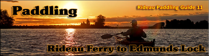
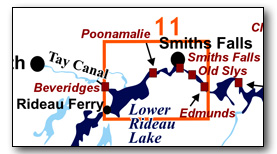
Paddling Lower Rideau Lake & the Rideau River (Rideau Ferry to Edmunds)
This has both easy lake and river paddling, with lots of marshland bordering the river in this area. There is some unsheltered open water in Lower Rideau Lake, so paddlers, particularly canoeists, should ensure that they do a weather check to make sure the winds are light prior to heading out on the lake. The map included in this guide can be enlarged (while viewing the PDF) to any level of detail you desire as an aid for travel planning.
You can view or download the PDF file:
| (Clicking this link will open the PDF. You can also just right mouse click the above link and use "Save Target As" to send the PDF directly to your computer.) |

Water Access
Water access is available at Rideau Ferry Conservation Area, Lower Beveridges Lock, Poonamalie Lock, Smiths Falls Detached Lock and Edmunds Lock. For direct access into Lower Rideau Lake there are three choices, the Rideau Ferry Conservation Area boat launch ramp (44° 51.400'N - 76° 08.130'W), the ramp at Lower Beveridges lockstation (44° 52.465'N - 76° 08.250'W) and the ramp at Poonamalie lockstation (44° 53.470'N - 76° 03.480'W). To access the area between Smiths Falls and Poonamalie (including The Swale) use the ramp at Smiths Falls Detached Lockstation (44° 53.755'N - 76° 01.715'W). To do the Rideau River between Smiths Falls and Edmunds, it is easiest to put in at Edmunds Lock (lots of parking with dock access above the lock).
Facilities
Lodging: If you're paddling and camping, the lockstations are a good choice for camp spots (a camping fee applies). There are hotels/motels in Smiths Falls and B&Bs in Westport, Perth and Merrickville. For information about local accommodations see: www.smithsfalls.ca, www.westportrideaulakes.on.ca, and www.rideau-info.com
Supplies: A local source for supplies is the town of Smiths Falls which has which full facilities (grocery stores, pharmacies, hardware stores).
Big Boats
You'll be sharing the Rideau with big power boats (cruisers). The Rideau is generally not a crowded waterway and often you'll find the large boats in "packs" - travelling from lock to lock - once they pass by you won't see any for awhile. Some of these boats can generate a large wave. The general rule for a paddler and large waves is to meet them head on, this can actually be fun in a kayak (not as much fun in a canoe).
The main navigation channel is shown on the map as a blue dashed line - this is where the big boats will be travelling. So, if you wish to avoid these, pick a route away from the navigation channel. Many paddlers prefer paddling near shore, it's more interesting (i.e. wildlife, cottages) and it keeps you farther away from the waves produced by big boats.
There are several "no wake" zones on the Rideau - these have been marked on the maps. Boaters within these areas are supposed to be travelling at a slow enough speed (less than 10 kph) that their boat doesn't generate any potentially damaging or dangerous waves.
Wind
A question often asked is which way does the wind blow? The prevailing wind, powered by the jet stream, is from the southwest. That's about the only rule of thumb. If a front is moving in then the wind can come from any direction. I've been on several paddles where I've been paddling into the wind on the way out in the morning and into the wind on the way back in the afternoon because the wind swung around 180 degrees (for some reason it never seems to work the other way around - at your back both ways). So, if you're going to travel the entire Rideau, going from Kingston to Ottawa improves the odds of having the wind at your back - but be prepared for anything.
Etiquette
Your trip planning should include a "leave no trace" approach - carry out what you carry in. Many areas are un-serviced (no garbage cans) - so plan to be self-contained. The lockstations provide waste disposal facilities.
Preparation & Safety
Please read the trip planning information on www.rideau-info.com/canal/paddling/. While these lakes are easy paddling, normal paddling preparations should be made (all required safety gear, maps, food, water, first-aid kit, etc.). Zebra mussels are present in many areas along the Rideau, so a pair of water shoes (to avoid cut feet) is recommended.
Please take all normal safety precautions, including checking the weather forecast before you head out and making sure that someone on shore knows your planned travel route and itinerary.
Navigation
While the Rideau is generally easy to navigate, taking along a set of maps is a must (in addition to any GPS you might have). Although the map in this guide is an accurate 1:50,000 representation of the waterway (when printed to 8.5" x 11"), you may also wish to also have the 1:20,000 hydrographic chart for this section (Chart 1513). For power boat navigation, the charts are an absolute must (the map in this guide should not be used for power boat navigation). The charts are also very handy for the paddler, since they show the Rideau in great detail, including depths (which can be helpful when looking for wildlife habitat or just interesting places to paddle).
The charts also show all the navigation buoys. These are all numbered (red buoys have even numbers, green buoys have odd numbers) and so can be used as an aid in locating yourself on the map when you're on open water. A subset of those buoy numbers have been included on the paddling guide maps.
For those wishing to go off the beaten path or want to know more of the topography and geographic features of the surrounding countryside, the 1:50,000 NTS maps for this section are 31C/16 and 31B/13.
Note: the Mud Cut on Lower Rideau Lake is no longer navigable by paddlers (info as of 2018).
Distances:
Circumference distances are approximate, following the main shorelines. The navigation channel is shown on the map.
- Rideau Ferry to Edmunds Lock along the navigation channel = 19.0 km (11.8 mi)
- Rideau Ferry to Poonamalie along the navigation channel = 10.6 km (6.6 mi)
- Poonamalie to Smiths Falls Detached along the navigation channel = 3.7 km (2.3 mi)
- Smiths Falls Detached to Smiths Falls Combined along the navigation channel = 0.6 km (0.4 mi)
- Smiths Falls Combined to Old Slys along the navigation channel = 1.4 km (0.9 mi)
- Old Slys to Edmunds along the navigation channel = 2.7 km (1.7 mi)
- Lower Rideau Lake - shoreline circumference = 26 km (16.2 mi)
- Poonamalie to Smiths Falls Detached - shoreline circumference = 16 km (9.9 mi)
(this includes the shoreline along the backchannel (original Rideau River) to the dam)
Lower Rideau Lake
This is the shallow east end of Rideau Lake, an area that was extensively flooded by the canal dam at Poonamalie, which raised the lake level by about 6 feet (1.8 m). The lake has a maximum depth of 25 feet (7.6 m) with an average depth of about 12 feet (3.6 m). In the pre-canal era, the start of the Rideau River was at Stonehouse Island (then a point), which was also the outlet of the Tay River. The winding navigation channel between Stonehouse Island and Poonamalie marks the course of the original (now drowned) river.
The land bordering the river is all privately owned except for the federal lands at the lockstations and the Rideau Ferry Conservation Area. Zebra mussels are present. Aquatic vegetation growth is present in most sheltered areas with a depth of less than 10 ft (3 m). Wildlife is abundant.
The Rideau River
The Rideau River is generally a slow moving river, the only appreciable currents will be from the outflow of the canal weirs during times of high water. The main hazard are these same weirs, some with overflow dams. These are well marked on the upstream side and paddlers should avoid getting too close to these. Zebra mussels are present. Aquatic vegetation growth is present in most sheltered areas with a depth of less than 10 ft (3 m). Wildlife is abundant.
Poonamalie to Edmunds Lock
These water in the river between the locks in this section has been raised by the various canal dams to the level it is today. The river channel has a maximum depth of 3 m (10 ft). The water depth outside of the marked channel averages about 1.2 m (4 ft). The land bordering the river is all privately owned except for the federal lands at the lockstations and some municipal lands in the section between Smiths Falls Detached and Old Slys.
The flooding by the dam at Smiths Falls Detached has produced some extensive wetlands in this section, including The Swale (see below for details). The river passes through the heart of the Town of Smiths Falls (urban development). Once past Smiths Falls (at Old Slys) the lands bordering the canal have rural development (some cottages, some farms).
The Locks
Most Rideau lockstations offer facilities such as washrooms, water, recycling cans, waste cans and picnic tables. Most also allow camping for paddlers travelling the Rideau for a modest camping fee. Paddlers can portage the locks for free, but you owe it to yourself to lock through at least one lock in order to get the full experience of paddling the Rideau Canal. See www.rideau-info.com/canal/fees.html for the current fee schedule.
Points of Interest (listed south to north)
Lower Rideau Lake: Much of the cottage development is along the southern shore (i.e. Miller's Bay). On the northern shore, in Beveridge Bay, you'll find the entrance to the Tay Canal, via the Beveridges Locks (see Section 10). You can also paddle up the Tay River to Port Elmsley and see the site of the first lock of the first (1834) Tay Canal. The lake east of Stonehouse Island is the flooded headwaters of the Rideau River and there are extensive marshlands with lots of wildlife in this area.
You're not the first paddler to enjoy this region. The oldest archaeological discovery on the Rideau Canal, a site that shows paleo-native occupation dating back to 6,050 B.C., was made in this area. The outflow of Rideau Lake was a prime hunting and fishing area, attracting native use for thousands of years and there are a number of occupation sites. It's unclear if there were ever any permanent settlements, and recent (last 500 year) native use of the Rideau has been transient (hunting and fishing camps).
Ferryland Cottage: Just to the north of the Rideau Ferry bridge, on the southeast shore, is a beautiful old cottage with distinctive turrets. It was built by Alexander Martin of Ottawa in the 1890s. Additions including a gazebo and a boat house were added over time.
Rideau Ferry Conservation Area: This is a day use facility, featuring a sandy beach, picnic tables, outhouses and a boat launch. It is run by the Rideau Valley Conservation Authority.
Camp Merrywood: At Stuarts Point as you come around into Beveridge Bay, you'll see Camp Merrywood, an Easter Seals camp (for children with physical disabilities) established in 1948.
Beveridges Locks: There are two separate locks at this station (lift of Lower Beveridges = 12 ft /3.6 m - Upper Beveridges = 10.9 ft /3.3 m). Although these look just like original Rideau Canal locks, they were in fact built over fifty years after the Rideau Canal was built. Constructed in the late 1880s, they were built using the original design specifications of the Rideau locks.
Stonehouse Island: This island (private property) was once used as a staging point for the Tay Navigation Company (1834 - 1840s). Goods would be offloaded from barges plying the Rideau Canal and then loaded onto smaller barges that could ascend the Tay Canal (which had smaller locks than the Rideau Canal) via Port Elmsley to Perth. Prior to the Rideau Canal being built, it represented the end of a point, the Tay River flowed into the Rideau River on the east side of that point.
Port Elmsley: The Weatherheads erected a dam and sawmill here in 1829. The first Tay Canal was opened in 1834, with Locks 1, 2 and 3 in the area of present day Port Elmsley. You can still see the remains of Lock 1 as you paddle into Port Elmsley (look for it on your right as you enter - a small island marks one wall of the original lock).
Lower part of Lower Rideau Lake: : East of Stonehouse Island you'll see that the navigation channel takes a long loop. It is following the original channel of the Rideau River. If you have a copy of the navigation chart, you can clearly see the old river channel from the depth readings on the chart.
Mud Cut: This used to be a shortcut that avoided the long loop. Today it is no longer passable by even paddlers in low water (info as of 2018). This shortcut was originally dredged between 1909 and 1911. Early navigation maps (1920s) show the main route of the canal as being through this cut. That dredging stopped some time ago (~1970s) and the channel has now filled in to the point that it is non-navigable.
Bacchus Island: This is a glacial drumlin (an elongated gravel ridge) formed during the last ice-age. The long direction of the island shows the direction of the ice movement in this area (in this case, south-southwest). The island is named after William Bacchus who briefly owned part of the island in the 1870s. The development on the island that you see today started in the 1940s, with a permanent causeway to the island built in the 1950s.
Poonamalie Dam: As you approach Poonamalie, you'll see the dam to the north of the cut that leads to the locks. This dam is sitting at the head of First Rapids, the first set of rapids on the Rideau River, flowing over hard layers of flat lying limestone. The dam that you can see today (worth a visit) is the third dam in this location. The original dam was a timber overflow dam with stone abutments. A timber weir was later incorporated into that dam. It survived until 1904 when a massive sheet of ice tore a 75 foot (23 m) wide hole in the dam. A new concrete dam was then built just a bit downstream from the original timber dam. In 1971, a new concrete dam was built, a bit downstream from the 2nd dam. It incorporated a large hydraulic water control gate.
Poonamalie Cut: The original plan for navigation was to place a lock to the north of the Rideau River in this location. But hard bedrock forced a re-design and the lock was placed in a long canal cut to the south of the river. As you paddle to the lock, you'll see both rubble stone and stone wall embankments lining the cut.
Poonamalie Lock: This station has a single lock (lift of 2.2 m / 7.1 ft). The lock is sitting in the middle of a canal cut that bypasses a shallow meander of the Rideau River. The dam, as previously noted, is sitting at the head of First Rapids. The name Poonamalie was given to this lock during construction. The name comes from Poovirundavalli, a town near Chennai (Madras) in India, which served as a garrison town for the British Army. The name was anglicized as Poonamallee and this was the originally spelling for the name of the lockstation. Speculation is that the cedar-lined banks of the Rideau River reminded one of the military men of the Indian garrison town.
You'll find a beautiful 2-storey lockmaster's house at this location. A short hiking trail extends from the lockstation, along the north side of the canal cut, to the dam.
Rideau River - Original Channel: If you turn north at the northeast end of the Poonamalie Cut (rather than following the navigation channel east) you'll be paddling into the original course of the Rideau River (now flooded from the dam at Smiths Falls Detached). You can follow the channel up to the base of the Poonamalie Dam.
The Swale: The Swale is 385 ha in size and is classified as a Provincially Significant wetland. It is a type of cattail marsh. It contains approximately 250 identified plant species. Similar to other marshes on the Rideau, this marsh is a haven for wildlife, particularly waterfowl. You'll also find lots of frogs and turtles.
Bascule Railway Bridge: Just west of Smiths Fall Detached Lock is a permanently raised railway bridge. This is a Scherzer rolling-lift railway bridge (a type of bascule bridge) built for the Canadian Northern Railway in 1912/13. The railway line was taken out of service in late 1978. In 1983 the bridge was designated as a National Historic Site of Canada - it is the oldest surviving bridge of this type in Canada.
Smiths Falls Detached Lock: This is a single lock (lift of 2.6 m / 8.5 ft) in a canal cut. You'll find the dam and weir, to the north of the lock, in the original channel of the Rideau River. It's called a "detached" lock since originally four contiguous locks were proposed for Smiths Falls. But the topography and fractured nature of the bedrock necessitated a change in plans, and this lock was detached from the combined locks and built in this location. The lock was known for a time as Jones Lock after several early lockmasters by that name.
Dangerous Portage: Abbott Street is very busy and Parks Canada discourages portaging, although they may facilitate a road crossing if the road gates are lowered, otherwise they will lock you through for free. Check-in with the lock staff when you arrive at the station.
Abbott Street Swing Bridge: This is a through plate girder swing bridge constructed in 1959. It has a closed clearance of 1.9 m /6.2 ft. It replaced an earlier swing bridge that was constructed here in 1897.
Cataraqui Trail: This all-season trail, part of the Trans-Canada trail system, follows an old railway bed. You find the northern end of the trail located at the south end of Ferrara Drive, 0.8 km south of Highway 15. For more information about the trail see: cataraquitrail.ca
New Smiths Falls Combined Lock: This is a single lock (lift of 7.8 m / 25.7 ft) in a canal cut. It's the most recent lock on the Rideau Canal, built in 1973/74 to replace the original combined locks. The change was made because the swing bridge over the original locks restricted traffic flow (see Beckwith Street Bridge). The new combined is an electric lock with the highest single lift on the Rideau Canal. Water enters from the floor of the lock to reduce turbulence.
Beckwith Street Bridge: This is a fixed high level (26 ft / 7.9 m) bridge. It was built in 1973/74, at the same time as the new combined lock. The need for this bridge was the reason the original combined locks were abandoned and a new lock built. Since the opening of the canal in 1832, there had been two bridges near this location, a swing bridge over the original combined locks and a fixed bridge over the bypass channel. The first bridge at the locks was a rolling bridge over the centre lock, later replaced by a swing bridge. In 1889, a new swing bridge was installed over the upper lock. It was replaced in 1923 and it was that bridge, by the 1960s, that generated complaints (too old, too narrow, too slow). To run a fixed high level bridge with the required minimum clearance of 22 ft (6.7 m) over the original alignment of the canal and locks meant that a number of buildings would have had to have been torn down to make room. This wasn't acceptable to the Town of Smiths Falls. In the end, amid much controversy, the configuration that we see today, a fixed high level bridge going over a relocated lock, and the original locks left in place, was implemented.
Here There Be Whales: If you were paddling here about 11,500 years ago, you would have been doing it in the company of whales. The bones of a humpback whale (Megaptera novaeangliae) were found in a gravel pit just north of Smiths Falls. This whale swam in the Champlain Sea that covered this area at that time (see the Geology section).
Old Smiths Falls Combined Locks: These are the original set of 3 locks, left in place when the new single-lock combined lock was built. They are interesting to visit since they are empty of water, revealing many of the engineering details (such as sluice tunnel valves) that are underwater in an operating lock.
1 Jasper Avenue: Located adjacent to the old Smiths Falls Combined Locks, this is the original lockmaster's house. It was built as a single storey defensible lockmaster's house in 1838-41. The second storey framed addition was done in 1927. From 1985 to 2015 it was the office for non-profit organization Friends of the Rideau. It is now the Smith’s Falls office of Le Boat.
Original Smiths Falls Dam: Another historical point of interest is the old dam (built in 1828-1831) that used to block the flow of the Rideau River (diverting it to the weir). Walk to the parking lot under the big water tower (near the Rideau Canal Museum). The stone retaining wall is actually the top four feet of the 23 foot high stone dam. It has been backfilled on both sides. Standing in the middle of parking lot puts you right above the original channel of the Rideau River.
Rideau Canal Visitor Information Centre: Formerly the Rideau Canal Museum, it is located just north of Smiths Falls Combined Lock, housed in part of an old grist mill (the Woods Mills complex). The mill complex underwent an extensive restoration in 1989-91, including the creation of a museum in the old granary section of the building. The museum operated from 1991 until it closed in 2012. Parks Canada is now maintaining it as visitor information centre until closing it to pubic in 2023.
Rideau Canal Office: When Parks Canada took over the Rideau Canal in the early 1970s, they made the very good decision to move their direct management of the canal from Ottawa to Smiths Falls, to place them right on the canal in a central location. That was originally in offices in downtown Smiths Falls. Part of the rehabilitation of the Woods Mills Complex included creating offices for canal staff in the eastern half of the restored building. Those offices were occupied in 1991.
Smiths Falls: : The largest community between Kingston and Ottawa, Smiths Falls offers a full range of stores and services. You'll also find some interesting museums. The Rideau Canal Visitor Information Centre (see above), the Smiths Falls Railway Museum, located just up the road (north) from Smiths Falls Detached Lock and Heritage House Museum, located just down the road (south) from Old Slys Lockstation.
Rideau Trail: This walking trail, which extends from Kingston to Ottawa, passes through Port Elmsley and Smiths Falls. In this area it mostly follows roadways. You find more info about it at: www.rideautrail.org.
Old Slys: This is a double lock (two locks in flight - combined lift of 5.0 m / 16.3 ft). The locks are at the head of a canal cut that leads back to the Rideau River. The waste weir is located in the original channel of the Rideau River to the south of the locks. The area below the original stone dam at this location was backfilled in the 1960s so that only the top few feet of the original 21 foot high dam remain visible.
A defensible lockmaster's house was built here in 1838, but it was torn down in 1965 and replaced with the current lockstation office.
The first road across the dam and locks was built in 1857, with a wooden swing bridge across the lock. The present steel truss swing bridge was installed in 1962.
CPR Railway Bridge: The original railway bridge was built in 1858 by the Brockville and Ottawa Railroad. Ownership transferred to the CPR sometime around 1900 and the bridge appears to have been upgraded at about that time.
Rideau River: This section of the Rideau River between Old Slys and Edmunds is typical river travel, the water depths average 6 to 8 feet (1.8 to 2.4 m). There is moderate density home/cottage development in some sections, with quite a bit of shoreline still in its natural state (farm frontage).
Edmunds Lock: This lockstation has a single lock, a weir and an overflow dam. The lock has a lift of 9.2 ft (2.8 m). A two-storey lockmaster's house is located on site (the lockstation office today). It was built in 1905, replacing an earlier stone defensible lockmaster's house that had been built here in the 1840s. Edmunds, accessed by road from County Road 17 (south side of the Rideau River) features extensive grounds (verdant lawns with large shade trees), lots of parking, and a boat launch.
This lockstation features a stone arch overflow dam. Originally, all of the dams designed by Colonel By and the other Royal Engineers were to be overflow dams (including the largest, the huge dam at Jones Falls). But, after seeing the effect of spring flooding, By quickly changed his plans, making many into non-overflow dams and adding waste-water weirs to all of them. In the case of Edmunds we have a combination of both - an overflow dam with a waste-water weir. He explained the weir in an 1830 report noting "the addition of a Waste Weir to preserve the Dam from the effects of Spring Floods." The dam has been doing a great job, it's only required normal maintenance. The weir was rebuilt in 1906-07.
Edmunds or Edmonds? The lock is named after James Edmunds, the first settler in this area. Over the years his name has been spelled Edmunds, Edmonds and even Edmons. Currently Parks Canada used Edmonds and the Canadian Hydrographic Service (charts) uses Edmunds. Either is fine. At one point this lock was known as Mills Lock, removing the issue of how to spell Edmunds.
Off The Beaten Path
Port Elmsley (8 km / 5 mi return from the navigation channel south of Stonehouse Island)
Leaving the navigation channel south of Stonehouse Island, turn north to the island. Paddle past it (either side) and head north to the mouth of the Tay River. Paddle up the Tay River to Port Elmsley. There is lots of undeveloped shoreline and marshlands in this area (wildlife viewing opportunities). As you come into Port Elmsley, you'll see a small island on your left (south side) - this is the location (44° 53.440'N - 76° 07.070'W) of Lock 1 of the first Tay Canal (opened in 1834, closed in the 1860s).
There are rapids at Port Elmsley with shallow areas and small rapids in the Tay River upstream of Port Elmsley. This area is generally non-navigable.
Poonamalie/The Swale (16km / 9.9 mi circumference)
This trip can be done from either the lock at Poonamalie or Smiths Falls Detached. It can be a short day trip or an off the beaten path exploration as a part of a larger trip. The two features here are the original channel of the Rideau River and The Swale.
At the northeast entrance to the canal cut into Poonamalie, head northwest to follow the original channel of the Rideau River. This can be paddled all the way up the base of the big dam at Poonamalie. The shorelines in this section are mostly undeveloped.
While The Swale is specifically the Class 1 wetland to the north of Smiths Falls Detached Lock, the whole section from Smiths Falls Detached to the canal cut entrance to Poonamalie features lots of marshland with its associated wildlife. This area is mostly undeveloped, with lots of natural shoreline.
Geology
As you paddle the Rideau Canal, the route you follow is defined by its geology. Geological highlights have been included in the Points of Interest listings and a general geological history of the route can be found on the Geology of the Rideau Page.
Wildlife Viewing
A section about wildlife viewing, what you might expect to see on your Rideau journey, has been included in text form in the PDF. A version of this information, that includes photos of some typical Rideau wildlife, can be found on the Fauna of the Rideau Page (in the ecology section of this website).
Errors
If you find any errors or omissions in this guide, please let me know (rideauken@gmail.com) and I'll get them fixed.
Terms of use
This guide may be freely used for personal purposes. Have fun on your Rideau paddling adventure.
Commercial use is not allowed in whole or in part without express written permission.
©2010- Ken W. Watson, All Rights Reserved.
You can view or download the PDF file:
| (Clicking this link will open the PDF. You can also just right mouse click the above link and use "Save Target As" to send the PDF directly to your computer.) |
|