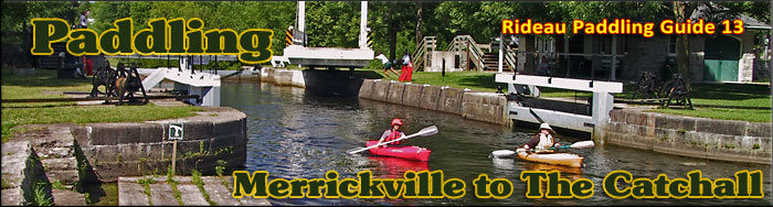
Paddling the Rideau River from Merrickville to The Catchall
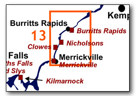
This is an easy paddling river section of the Rideau River, with a few single locks (Clowes, Upper Nicholsons, Lower Nicholsons and Burritts Rapids). The map included in this guide can be enlarged (while viewing the PDF) to any level of detail you desire as an aid for travel planning.
You can view or download the PDF file:
| (Clicking this link will open the PDF.) |

Water Access
Water access is available at all the locks; Merrickville, Clowes, Nicholsons and Burritts Rapids. At Merrickville, the entrance to the lockstation is between St. Lawrence St. and Elgin St (at 111A Main St E - opposite the Royal Bank). Parking is limited, so once you've offloaded your canoes/kayaks (from the parking lot - do not drive on the grass), you should park back on the street, or in the parking lot by the Blockhouse. Let the lockstaff know what you're doing. At Clowes and at Lower Nicholsons, parking is on the top of the hill. Ask the lockstaff for permission to drive down to the lock and offload your boats and gear. At Upper Nicholsons there is parking right at the lockstation. At Burritts Lock, you can park fairly close to the lockstation. There is also a spot where canoes/kayaks can be launched beside the south bridge at Burritts Rapids ( 44° 58.800'N - 75° 47.750'W). There is also a small ramp at the foot of Muldoon Road (on the south side of the Rideau River, about 2.5 km NE of The Catchall: 45° 01.400'N - 75° 42.400'W. - shown on the map in Guide 13)
Facilities
Lodging: If you're paddling and camping, the lockstations are a good choice for camp spots (a camping fee applies). There is also the Lions Park Campground in Merrickville, a host of B&Bs and several hotels (Merrickville and Smiths Falls). For information about local accommodations see: www.smithsfalls.ca and www.rideau-info.com (this website).
Supplies: A local source for supplies is the town of Smiths Falls which has which full facilities (grocery stores, pharmacies, hardware stores).
Big Boats
You'll be sharing the Rideau with big power boats (cruisers). The Rideau is generally not a crowded waterway and often you'll find the large boats in "packs" - travelling from lock to lock - once they pass by you won't see any for awhile. Some of these boats can generate a large wave. The general rule for a paddler and large waves is to meet them head on, this can actually be fun in a kayak (not as much fun in a canoe).
The main navigation channel is shown on the map as a blue dashed line - this is where the big boats will be travelling. So, if you wish to avoid these, pick a route away from the navigation channel. Many paddlers prefer paddling near shore, it's more interesting (i.e. wildlife, cottages) and it keeps you farther away from the waves produced by big boats.
There are several "no wake" zones on the Rideau - these have been marked on the maps. Boaters within these areas are supposed to be travelling at a slow enough speed (less than 10 kph) that their boat doesn't generate any potentially damaging or dangerous waves.
Wind
A question often asked is which way does the wind blow? The prevailing wind, powered by the jet stream, is from the southwest. That's about the only rule of thumb. If a front is moving in then the wind can come from any direction. I've been on several paddles where I've been paddling into the wind on the way out in the morning and into the wind on the way back in the afternoon because the wind swung around 180 degrees (for some reason it never seems to work the other way around - at your back both ways). So, if you're going to travel the entire Rideau, going from Kingston to Ottawa improves the odds of having the wind at your back - but be prepared for anything.
Etiquette
Your trip planning should include a "leave no trace" approach - carry out what you carry in. Many areas are un-serviced (no garbage cans) - so plan to be self-contained. The lockstations provide waste disposal facilities.
Preparation & Safety
Please read the trip planning information on www.rideau-info.com/canal/paddling/. While these lakes are easy paddling, normal paddling preparations should be made (all required safety gear, maps, food, water, first-aid kit, etc.). Zebra mussels are present in many areas along the Rideau, so a pair of water shoes (to avoid cut feet) is recommended.
Please take all normal safety precautions, including checking the weather forecast before you head out and making sure that someone on shore knows your planned travel route and itinerary.
Navigation
While the Rideau is generally easy to navigate, taking along a set of maps is a must (in addition to any GPS you might have). Although the map in this guide is an accurate 1:50,000 representation of the waterway (when printed to 8.5" x 11"), you may also wish to also have the 1:20,000 hydrographic chart for this section (Chart 1513). For power boat navigation, the charts are an absolute must (the map in this guide should not be used for power boat navigation). The charts are also very handy for the paddler, since they show the Rideau in great detail, including depths (which can be helpful when looking for wildlife habitat or just interesting places to paddle).
The charts also show all the navigation buoys. These are all numbered (red buoys have even numbers, green buoys have odd numbers) and so can be used as an aid in locating yourself on the map when you're on open water. A subset of those buoy numbers have been included on the paddling guide maps.
For those wishing to go off the beaten path or want to know more of the topography and geographic features of the surrounding countryside, the 1:50,000 NTS maps for this section are 31B/13 and 31G/4.
Distances:
Circumference distances are approximate, following the main shorelines. The navigation channel is shown on the map.
- Merrickville Locks to The Catchall along the navigation channel = 15.4 km (9.6 mi)
- Merrickville Locks to Clowes Lock along the navigation channel = 3.3 km (2.0 mi)
- Clowes Lock to Upper Nicholsons Lock along the navigation channel = 0.8 km (0.5 mi)
- Upper Nicholsons to Lower Nicholsons Lock along the navigation channel = 0.3 km (0.2mi)
- Lower Nicholsons Lock to Burritts Rapids Lock along the navigation channel = 5.4 km (3.4 mi)
- Burritts Rapids Lock to The Catchall along the navigation channel = 5.6 km (3.5 mi)
The Rideau River
The Rideau River is generally a slow moving river where the only appreciable currents will be from the outflow of the canal weirs during times of high water. The main hazard are these same weirs, some of which have associated overflow dams. These are well marked on the upstream side and paddlers should avoid getting too close to these. Zebra mussels are present. Aquatic vegetation growth is present in most sheltered areas with a depth of less than 10 ft (3 m).
Merrickville Locks to Burritts Rapids Locks
In the pre-canal era, the river was a few feet lower than it is today. Water levels have been raised by the canal dams at Clowes, Nicholsons and Burritts Rapids.
The river channel has a maximum depth of 14 ft (4.3 m). The water depth outside of the marked channel averages about 4 ft (1.2 m). The original channel of the Rideau River is bypassed by the canal cut at Nicholsons and by the canal channel (a flooded ravine) at Burritts Rapids. The land bordering the river is all privately owned except for the federal lands at the lockstations. There is moderate cottage/home development between Merrickville and Nicholsons, and less development (more farm frontage) between Nicholsons and Burritts Rapids.
Burritts Rapids to The Catchall
In the pre-canal era, the river was a few feet lower than it is today. Water levels have been raised by the canal dam at Long Island.
This section marks the head of the Long Reach, the longest stretch of the Rideau Canal uninterrupted by locks. It extends 40 km / 25 mi from the Burritts Rapids Lock to the Long Island Locks. The river channel has a maximum depth of 12 ft (3.6 m). The water depth outside of the marked channel averages about 4 ft (1.2 m). The Catchall is a meander of the Rideau River that is now bypassed by a dredged canal cut. The land bordering the river is all privately owned except for the federal lands at the lockstations. There is modest cottage/home development near Burritts Rapids changing to more farm frontage.
A short "scenic route" suggestion has been made to follow the original channel through The Catchall.
The Locks
Most Rideau lockstations offer facilities such as washrooms, water, recycling cans, waste cans and picnic tables. Most also allow camping for paddlers travelling the Rideau for a modest camping fee. Paddlers can portage the locks for free, but you owe it to yourself to lock through at least one lock in order to get the full experience of paddling the Rideau Canal. See www.rideau-info.com/canal/fees.html for the current fee schedule.
Points of Interest (listed south to north)
Merrickville Locks: There are three detached locks at this location (total lift of 7.6 m / 25.0 ft). The lockstation office is located adjacent to the middle lock. The largest blockhouse on the Rideau Canal is located beside the upper lock. The locks are spread out as three separate locks in order to take advantage of the topography, if they had been built as three locks "in-flight" (combined) it would have required much more excavation and/or embanking.
The original water control dam was at the head of the canal cut (see Depot to Dam Trail below). A stone dam extended partway across the river with a timber/gravel dam and waste water weir placed in the main channel. It was placed in this location to avoid interfering with the mills, which had their own dam (at or near the location of the present day dam and roadway). With the canal dam upstream in this location, the water level of the Rideau River going into the canal cut could be controlled, with most of the flow of the river going unhindered to the mills.
However, the timber construction of the weir led to all sorts of trouble and it wasn't strong enough to withstand high water flows. It was swept away in 1841 and rebuilt somewhat stronger. However, that threatened to give away in 1847 and only with the help of many residents of the town were the dam and weir saved. It was damaged again in 1862 but survived. In 1912, the position of the weir was relocated to where it is today, in alignment with the upper lock. The original weir was removed, leaving just the stone portion of the dam.
The first bridge was a rolling bridge positioned across the upper lock. It was replaced by a timber swing bridge, also across the lock, in 1843. In 1892 a steel bridge was installed on a new alignment, just below the upper lock (so that small boats could pass in and out of the lock without having to swing the bridge). The current electric swing bridge was installed in 1990.
The present day paddler’s portage has one dangerous road crossing. The lock staff will be happy to provide traffic control so that you can safely cross the road.
Merrickville Blockhouse: This is the largest blockhouse on the Rideau Canal. It is open to the public during the summer season, operated by the Merrickville and District Historical Society. The grassy picnic area beside the upper lock is known as Blockhouse Park. The blockhouse was built in 1832 to help defend this critical spot (near the road to the St. Lawrence River, a likely route for American invasion forces). The building served as a home to the early lockmasters, although by the 1870s it was starting to deteriorate. The resident at the time, Lockmaster Matthew Johnson noted that "The building generally is minus of its original evenness." The foundations were sinking and the roof had separated from its support posts. In 1909, the second floor, which at the time was made of masonry, had to be removed. The government was ready to tear the building down in the early 1960s, but fortunately heritage prevailed and the building was rehabilitated in 1962-65. For more info see: www.merrickvillehistory.org
The Depot: This is the summer home of Friends of the Rideau, who operate it as a visitor centre and retail outlet (including the sale of many books about the heritage of the Rideau). The building dates to about 1857, originally built as a storehouse with a wharf in front of it. For more info see: www.rideaufriends.com
Merrickville: This very pretty village is filled with various artisan shops and stores that cater to visitors. It is located at the site of the "Great Falls" - a waterfall (4.2 m / 14 ft) in the Rideau River. In about 1790, this water power attracted a miller, Roger Stevens, to set up a sawmill here (he had settled in a spot a bit downstream from this location in 1789). By 1793, the year that he died of drowning, he had apparently sold it to William Mirick. William continued to develop the site and by the early 1800s, a small community, known as Mirickville (later Merrickville) was developing. The coming of the Rideau Canal allowed Merrickville to become a full-fledged village. The Rideau River continued to power a series of mills, foundries and factories through the 19th century. A heritage walking tour brochure of the town can be found at several locations and on-line.
Industrial Heritage Complex: Located on what was an island between the original channel of the Rideau River and a flood channel of the river, this area housed several stone buildings, which included at various times a grist mill, a woollen mill, an oatmeal mill, a sawmill and a foundry. Today, only ruins remain of these buildings. In the old foundry you'll find many interpretive displays created and maintained by Parks Canada.
Depot to Dam Trail: This is a trail that leads from The Depot, across the upper lock and then south, to the entrance of the canal cut. The path then goes along the top of the stone dam (the original canal dam) that extends from the canal cut to the original channel of the Rideau River. An interpretive brochure for the trail is available at The Depot (also available on-line).
Merrickville Railway Bridge: A high level railway bridge was first built here in 1887 by the Ontario and Quebec Railway. The current bridge dates to 1906-1907 when it was rebuilt by the Canadian Pacific Railway.
First Rideau Bridge: Now long gone, the area near marker buoy N286 was the location for one of the earliest (likely the first) bridge across the Rideau River. This bridge is shown on an 1816 map as crossing the river (then a few feet lower and much narrower) at this location to a spot called "Chesters" located on the west side of the river. The bridge provided a link to roads on both sides of the Rideau River. The road on the east side had connecting roads to Kingston, Brockville and to near where Kemptville is today. The road on the west side was cut through the forest in 1815. It led back to Rideau Falls (Ottawa). It crossed to the east side of the Rideau River with a ford at Black Rapids and then led to the portage at Rideau Falls (on the east side of the falls).
McGuigan Cemetery: This cemetery, open to the public, is the oldest burial ground on the Rideau Canal. The first burial was that of Samuel McCrea who died in 1806. The cemetery saw continued use to the 1890s. The most poignant (and uniquely designed) grave marker is that for Margaret Davidson, the one year old daughter of Clowes Lock contractor, P. Davidson. She died from "a contusion to the head" in November 1829. You'll find the entrance to the cemetery at 448 County Rd. 23 (Burritts Rapids Rd.). It's about a 1 km walk from Upper Nicholson's lockstation.
Clowes Lock: This is a single lock with a lift of 7.5 ft / 2.3 m. This site was originally known as Clowes' Quarry due to a quarry opened up at the beginning of canal construction by James Clowes (the quarry is on the west side of the river, just a bit downstream from the Upper Nicholsons dam). The river here dropped 11.5 ft (3.5 m) in a set of rapids about 1,015 m (1,115 yd) long. The lock was originally intended to be on the east side of the river, in line with the locks at Nicholsons, but hard bedrock in that location forced Colonel By to re-locate the lock to the west side of the river. You'll also notice that this lock has no breastwork (upper foundation). This was simply a cost saving measure since By found that the flat bedrock could serve as an upper foundation and he had a wooden sill anchored to it.
Clowes features an arch stone overflow dam and a weir. The old lockmaster's house sits on the hill, just a bit downstream from the lock.
Channel Crossing: You'll have to cross the Rideau River in going to/from Clowes Lock to the Nicholsons Cut. The river current is usually very modest so this isn't a problem, but you should be aware of the Nicholson's overflow dam. In the 1800s, the tow line to a barge being towed by a steam tug broke and the barge went over the Nicholson's dam. A woman and a little girl on board the barge luckily survived with only a soaking (the barge was left where it was, it eventually deteriorated and was washed away).
Nicholsons Locks: There are two detached locks at this station with a combined lift of 14.1 ft / 4.3 m. Upper Nicholsons features an unequal arm, center-bearing timber swing bridge, one of only four remaining on the Rideau. You'll also find an osprey nest between the lock and the Andrewsville bridge. The old lockmaster's house is on the hill above the canal cut between the two locks.
The original plan for this spot called for a dam lower down on the rapids with a combined set of two locks. But it was found that the original surveys were in error and if the dam had been placed lower down, much more agricultural land would have been flooded (requiring compensation to the landowners). So, the dam was moved to the head of the rapids and a cut was excavated on the east side of the locks and two detached locks were placed in the cut.
The lockstation features an arch stone overflow dam. The weir is incorporated into the canal cut, not the dam. The weir was an afterthought, the dam was already being constructed, so it may have been a case of that it was simpler to excavate the weir into the canal cut than to incorporate it into the dam.
The canal cut had leakage problems, with water in the cut leaking back into the Rideau River. To stop the leakage, a cement wall, lining the cut, was constructed between 1910 and 1913, replacing the original dry stone wall.
Andrewsville: This village got its start when Silas and Rufus Andrews built a sawmill and a shingle mill at this site prior to 1860. In 1861 they added a grist mill. The concrete piers of the dam used to create a head of water for those mills are all that remains today. The mills had stopped operating by 1930.
Andrewsville Bridge: The first bridge in this location was a fixed timber bridge, built in 1864, the same year a timber swing bridge was built across the lock at Upper Nicholsons. The present steel through truss bridge was erected in about 1900. When the dam at Poonamalie was breached by ice in 1904, the resulting flood waters washed out the east abutment of the Andrewsville bridge (the bridge itself survived intact, with its east end plunged into the Rideau River). The bridge has been repaired many times over the years, most recently in 2008. In 2012 recommendations were put forward to close the bridge to vehicular traffic and maintain it for pedestrian and cyclist use. Those were reversed in late 2012 with the recommendation that the bridge be repaired and maintained for light vehicular traffic. Its future status remains in limbo.
Roger Steven's Homestead: In 1789, the first settler in this part of the country arrived. Roger Stevens, his wife Polly and their three young children started to homestead on the shores of the Rideau River, near the border of Montague and Marlborough townships. At some point after this, he decided to go into the milling business, erecting a sawmill at the Great Falls (Merrickville). By 1793 he had plans in the works to add a grist mill, but that fall he drowned (in a tributary to the Rideau River, assumed to be today's Stevens Creek). Later that fall, his house and all its belongings were lost in a fire, leaving his widow Polly and their three children destitute. She petitioned to have land in the area granted to her and her children, but she was turned down. Stevens' sawmill had apparently been sold to William Merrick shortly before Steven's death.
Stephen Burritt's Arrival: The southeast side of the river, just a bit downstream from Roger Steven's homestead, is the likely location where Stephen Burritt arrived at the Rideau River in 1793. History records that he arrived at the Rideau River at Cox's Bay. Today's Rideau Creek used to be called Cox's Creek and there was a small set of rapids here. This would place the location just a bit downstream from Roger Steven's homestead. Burritt built a raft and floated downstream to the location of Burritt's Rapids where he found a location suitable for settlement.
Burritts Rapids Canal Channel: At the southwest end of Burritts Island, the original channel of the Rideau River continues to the west (to an overflow dam) and the navigation channel goes east to the lock (at the northeast end of the island). This channel was created by the flooding of an existing ravine (the Oxford Snie, a relict flood channel of the Rideau River) and extensive berming. As a by-product, it also created the island on which the main village sits today.
Burritts Rapids: The community was founded by Stephen and Daniel Burritt, who arrived here in 1793. In 1824, a bridge (one of the earliest on the Rideau) was built across the Rideau River (near the location of today's north bridge, over the original channel of the Rideau River). By the time of the building of the Rideau Canal, Burritts Rapids was a small village. At the north end of town (adjacent to County Road 2) is the historic Anglican Christ Church, built in 1832.
Burritts Rapids Swing Bridge: When the navigation channel was created, a bridge was needed to get from the island to the east shore. In about 1831, a high level timber bridge was built (elevated 28 feet (8.5 m) above the channel), located a bit upstream from the present day swing bridge. That high level bridge was abandoned when a new timber swing bridge was built in 1850, at the location of today’s swing bridge. The current steel truss swing bridge dates to 1897. It was extensively renovated in 2017/18.
Old Methodist Church: Just downstream of the swing bridge, you'll see a lovely white coloured wooden church, the old Methodist Church. The church was opened as a Methodist Church in 1855, later becoming a United Church. The bell and tower date to 1899. It was turned into a private home in 1974.
Tip to Tip Trail: This is 2 km long trail extending along the southern side of the island. A brochure, with a map and guide to the trail, can be found at the Burritts Rapids Lockstation (and on-line).
Burritts Rapids Lock: This is single lock with a lift of 3.2 m / 10.6 ft. It is located at the foot of "Oxford Snie," the relict flood channel of the Rideau River that was used to make a navigable channel, bypassing the rapids in the Rideau River (you can still see some of those rapids today in the north channel of the river).
Rideau River: : You can paddle the original channel of the Rideau River from the foot of Burritts Lockstation to the Burritts Rapids Dam. See Off the Beaten Path below.
The Long Reach: Leaving the lock at Burritts Rapids, you're entering the Long Reach, the longest section of the Rideau Canal uninterrupted by locks (40 km / 25 mi). The canal dam at Long Island, the next set of locks, raised the Rideau River in that location by about 26 ft (8 m), flooding it all the way up to the foot of Burritts Rapids and making the entire section navigable (the main rapids that were flooded were those at Long Island itself).
Early Bridge Location: Near buoy N222 is the location of a pre-canal bridge crossing the Rideau River. The bridge shows up on an 1827 survey of the river. This may have been the bridge built by Eli Hurd (who lived nearby) in 1826. On the northwest side of the river near this location Olmstead operated a tavern in his log house.
The Catchall: This is an original meander of the Rideau River. One interpretation of the name is that this spot would catch all the debris being carried down the river by spring flooding. The river, both pre and post canal, carried uprooted trees and other debris, depositing them where currents slowed or the river took a meander. Surveyor John Burrows, during his May 1827 survey, noted in the area between here and Burritts Rapids, that "the river here much diminished in size by quantities of flood wood on both sides."
A dredged cut was made to straighten the channel and bypass The Catchall in the mid-1900s.
Off The Beaten Path
Burritts Rapids
If you wish to see the original Burritt's Rapids, paddle from the foot of the Burritts Rapids lockstation into the north channel and head west to Burritts Rapids. You can easily pass under the fixed bridge and paddle up to the Parks Canada dam (take care not to approach too close - there can be dangerous undertows). The shallows you cross are the original rapids.
The area just west of the fixed bridge is also where the Rideau River was dammed to provide power for mills. The remains here date back to milling activity that started in about 1845. You can still see some of the concrete-capped, stone-filled wooden cribbing of the dam. Just upstream are the remains of a triangular ice breaking crib (used to protect the dam). The dam provided power for a sawmill, a grist mill and a woolen mill. On the south bank, the partial remains of a sluice can still be seen.
Geology
As you paddle the Rideau Canal, the route you follow is defined by its geology. Geological highlights have been included in the Points of Interest listings and a general geological history of the route can be found on the Geology of the Rideau Page.
Wildlife Viewing
A section about wildlife viewing, what you might expect to see on your Rideau journey, has been included in text form in the PDF. A version of this information, that includes photos of some typical Rideau wildlife, can be found on the Fauna of the Rideau Page (in the ecology section of this website).
Errors
If you find any errors or omissions in this guide, please let me know (rideauken@gmail.com) and I'll get them fixed.
Terms of use
This guide may be freely used for personal purposes. Have fun on your Rideau paddling adventure.
Commercial use is not allowed in whole or in part without express written permission.
©2010- Ken W. Watson, All Rights Reserved.
You can view or download the PDF file:
| (Clicking this link will open the PDF.) |
|