The Surveyors
by Ken W. Watson
Mapping the Rideau Route
Over a period of forty years, the documented (map) knowledge of the “Rideau Route” evolved from simply knowing the route existed to detailed maps and reports showing the full geographic location of the route and the navigation impediments that had to be overcome in order to create a navigable waterway. It was the work of surveyors, men who ventured out by canoe and on foot, to explore and map. These are the stories of their work and how it evolved our knowledge of the Rideau Route.
Lt. Gershom French – 1783
“… we continued about 8 miles in the same direction to the River du Rideau and by a Carrying Place of a Mile entered our canoes into the Rideau.” So wrote Gershom French on October 2, 1783. This is the first written record of a Rideau Route survey. French, a loyalist, was a Lieutenant in the Corps of Loyal Rangers under Major Edward Jessup and he was tasked with exploring a native travel route between the Ottawa and St. Lawrence rivers. French was 40 years old at the time, an experienced man having served with loyalist military units since 1776.
His survey started on September 29, 1783, on the Ottawa River, with the first entry in his journal stating “1783 – Sept 29th – Departed from Carillon with seven men of the Provincials, Two Canadians and an Indian as Guide with two Bark Canoes …” The Provincials were men of the Provincial Corps of the British Army and the Canadians were French-Canadians (voyageurs). The aboriginal guide was key, since they were going to be following a native canoe travel route between the Ottawa and St. Lawrence rivers, one which followed the Rideau River to the Rideau lakes and then down the Gananoque River to the St. Lawrence River, a route not previously surveyed by Europeans.
French’s main mission wasn’t actually to document a navigation route, it was to assess the landscape in terms of settlement. On his first day on the Rideau, October 3, 1783, he travelled between Rideau Falls and Black Rapids and wrote in his journal:
“From the Carrying Place we steered up the Rideau South 15 degrees west, five miles in deep still water and then for about 7 miles further in a Rapid Current. In this days journey the canoes were navigated by two men each, a party travelled on each side [of] the River, myself always being one, changing sides occasionally and frequently leaving the River at half a mile distance.
The banks of the River in general raise about twelve feet above the high water from thence the land continues very Level, it is a Dark Soil from 7 to 10 Inches Deep, with a Sandy Loam below, clear of Rocks and Stones, Timbered with Maple, Beech, Birch, Elm, Butternutt &c. with an Edging of Cedar and Pine always covering the Banks of the River and wherever the water is Rapid, the Shores are Lined with Lime-Stones, in the Route there were two excursions made one each side [of] the River to the distance of a league in which myself and party found the land Everywhere good.
We Encamped at the Entrance of a Small Rapid River from the North West forming a Convenient Mill place.”
We see from this description that he was focused on two aspects of the route: he was looking at the landscape in terms of its suitability for farming and he was noting potential mill sites. Every few miles he would run a traverse for a league (3 miles / 5 kilometres) on either side of the river to check out the character of the land.
His native guide took him along a well-established canoe route that led to Rideau Lake, then over a portage across the Isthmus (Newboro) to put in at Newboro Lake, through the next lakes, portaging past Chaffey’s Rapids and the Jones Falls rapids. The rapids at Jones Falls were the head of the White Fish River, which passed through White Fish Falls (Morton) and into Lower Beverley Lake. At this time there was no direct water connection between Sand Lake, the last pre-canal Rideau region lake, and the Cataraqui River. A flood plain (Cranberry Flood Plain), which was dry in the summer, barred a navigable water connection. So he went down the Gananoque River, ending up in the St. Lawrence River at Gananoque Falls (Gananoque) on October 13, 1783.
His map, which was put together 10 years after his trip from sketches he provided, is not very accurate. The Ottawa and St. Lawrence rivers were already well mapped, but beyond that his trip depended on the travel route knowledge of his native guide. His sketches were based on his compass headings and general dead reckoning. When we look at his map, produced in 1794, we’re not sure how many elements were later added by the draftsman, William Chewett, incorporating an additional 10 years of information.
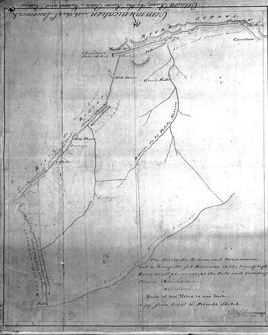 French’s 1783 Rideau Route Map
“Communication with the St. Lawrence & Ottawa Rivers, by the Rivers Petite Nation and Rideau” copied
from sketches by Lt. Gershom French 1783, by William Chewitt, August 26, 1794, Archives of Ontario,
AO1336 (left panel).
French’s 1783 Rideau Route Map
“Communication with the St. Lawrence & Ottawa Rivers, by the Rivers Petite Nation and Rideau” copied
from sketches by Lt. Gershom French 1783, by William Chewitt, August 26, 1794, Archives of Ontario,
AO1336 (left panel).
We do have a bit of a puzzle with French’s survey notes and map, and that’s the significant lack of detail in the southern part of his journey, from Jones Falls to Gananoque. There were rapids and waterfalls in this section, several requiring portages. In the northern part of his survey, French records portages and mill places, however these are absent from the southern part of the map. He shows lakes all the way down to Sand Lake, but a similar sized lake, Lower Beverley Lake (which French had to paddle through), is absent. Why is this? We don’t really know but there is some speculation.
 |
 |
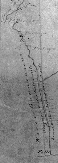
The Mystery of French’s Map
As French travelled south, he mapped the route and noted waterfalls and portages, that is
until the Jones Falls Rapids, his last noted portage. After that his route shows almost a direct
line to the falls at Gananoque. A look at his actual route shows not only that it should have
included several loops but that there were also at least 6 portages between the portage at
Jones Falls and the last one at Gananoque Falls (clearly noted on Lewis Grant’s 1795 map
shown on page 130). None of these are noted on either French’s map or in his survey report.
Map on left a section from: “Communication with the St. Lawrence & Ottawa Rivers, by the Rivers Petite
Nation and Rideau” copied from sketches by Lt. Gershom French 1783, by William Chewitt, August 26,
1794, Archives of Ontario, AO1336. Map on right by Ken W. Watson.
|
A year after French’s survey, in October 1784, French’s former commander, Major Edward Jessup, sent a letter to the authorities in Québec reporting that he had learned of an “iron oar bed” in the region. He appears to have been applying to erect an iron works in the area (both mineral rights and water power rights were reserved to the Crown and applications had to be made). The iron ore bed was located on Lower Beverley Lake and power for an iron works (a furnace) was located at the ‘Great Gananoque Falls,’ the location of present day Lyndhurst. How did Jessup know about this?
The significant falls at Lyndhurst (which would have required a portage) aren’t noted in French’s report or on his map. Did he come across the iron ore on one of his traverses, keep it quiet and later report this to Major Jessup? We have no way of knowing, but it is rather suspect. However, Jessup didn’t pursue his 1784 application; it would be about fifteen years before a furnace was built and the ore was mined.
French himself appears to have been living at the time in Québec City, he never took advantage himself of anything he learned on his travels. He later moved to Coteau du Lac, Soulanges Co., Québec, and passed away there in 1831.
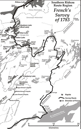
Lewis Grant – 1795
There wasn’t much settlement pressure in the Rideau corridor during the first few years after French’s survey. The first mills, the King’s Mills, were constructed at Cataraqui Falls (Kingston Mills) in 1784 and some settlement started to take place in this area. In the northern part of the Rideau, Roger Stevens arrived in 1790 and built a sawmill at the location of the Great Falls (present day Merrickville). But most settlement at the time was in townships bordering the St. Lawrence River and Lake Ontario. The surveying of interior townships didn’t start until about 1791.
Surveying was sometimes sparked by settlers making petitions for land. Land couldn’t be granted until a township, with lots and concessions, had been laid out. In December 1793, Abel Stevens (Roger’s brother) made a land petition which stated in part “Your Petitioner therefore prays he may be confirmed in the above location and that a surveyor may be directed to survey it. ... so that your petitioner may begin to improve early next Spring - as he wishes to erect a Dwelling House and Sawmill and make considerable Improvements there next season.” He was looking for land in what was to become Bastard Township, not yet surveyed.
And so, in 1795, Provincial Land Surveyor Lewis Grant was ordered to start a survey with the eventual intent of establishing a fully surveyed township. This led to the next ‘route survey’ – the section from Gananoque to Sand Lake. Grant’s first requirement was to explore the lay of the land and try to tie into survey lines run in 1794 by surveyor William Fortune.
Grant’s 1795 map clearly shows all the rapids, waterfalls and portages that were absent from French’s map. His map includes his own survey, shaded blue on the original map, and information “taken from an Indian Plan of the River Gananoque and adjacent country.” This part shows, in a blobby form, some of the Rideau Route lakes such as Opinicon, Indian, Newboro and Upper Rideau.
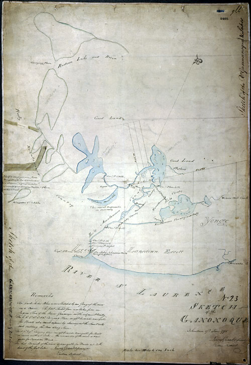 Lewis Grant’s 1795 Survey Map
“Sketch of the Ganonoque” by Lewis Grant, 1795, Archives of Ontario, AO1532.
Lewis Grant’s 1795 Survey Map
“Sketch of the Ganonoque” by Lewis Grant, 1795, Archives of Ontario, AO1532.
The general lack of European knowledge of the region is evidenced by the fact that Grant initially took a wrong turn, heading up Wiltse Creek (rather than continuing along the Gananoque River) and ending up in Charleston Lake. “In going up the Gananoque I mistook the East branch of the river for the West and proceeded up on to the head of the first Lake [Charleston] by that means.” At some point, likely a bit east of Wiltse Lake, he realized his error, backtracked and then continued up the Gananoque River, eventually paddling into Lower Beverley Lake and then up the White Fish River to Jones Falls and from there to Sand Lake where he ended his survey.
He did clearly note on his map, in reference to the Cranberry Flood Plain (between the White Fish River and the Cataraqui River), that it was “impassable in summer.” Part of his ‘Indian Plan’ shows a portage link between Loughborough Lake and Opinicon Lake (likely through Hart Lake) and notes that this was the canoe route from Kingston to the Rideau with “a great number of rapids and carrying places.”
Grant only put in a few tie lines during this preliminary survey. He returned the next year and completed a full lot and concession survey of Bastard Township. By this time, Abel Stevens, together with several other families, had fully established themselves and erected a mill at Stevenstown, the site of present day Delta.
The Land Surveyors – 1791+
Most of the initial township surveys along the Rideau were done between 1791 and 1807. The surveyors were tough men doing a tough job. The 1791 field book of Deputy Provincial Surveyor Jesse Pennoyer, for his survey of Oxford Township, records some of the difficulties these men faced.
Pennoyer left Edwardsburg (Cardinal) on the St. Lawrence River on March 30, 1791. Pennoyer was accompanied by another surveyor, Christian Theodore De Pencier. In advance of the survey, they had sent “carters” ahead to stash provisions (items such a pork, flour, tea and tobacco) along the route. They had also sent some of the survey party on ahead. They travelled up the St. Lawrence and then disembarked to follow an Indian trail north to the South Branch of the Rideau River (today’s Kemptville Creek).
Their first major challenge was crossing the “River Petit Nation” [South Nation River] since a ford couldn’t be found. They built a raft out of green wood, but when tried with two men on it, the raft sank “and with much difficulty we saved the men from drowning.” So, they built a larger raft, tried that one out with five men on it and it too sank. The next day (April 1, 1791) they set about building a third raft, this time searching far and wide for dry wood. Work halted the next day as they took refuge from “A violent snow Storm.”
On April 3, with the new (third) raft, they successfully crossed the river and then met the rest of their survey group (the ones who had been sent on ahead) at the “River Rideau” (likely Kemptville Creek). He found that his men had already made one canoe – this would have been a dug-out canoe made from a large log. He sent men into the woods to find “a Tree for another Canoe.” They spent the next four days building the second canoe and constructing a raft. Finally on April 9, they hit the river with their flotilla. It wasn’t until April 13 that Pennoyer was able to start his first survey traverse.
The next few days he records running traverse lines. He notes some good land but also “met with some bad swamps.” April 24 was Easter Sunday and he writes “the party [being] mostly Roman Catholic I gave them liberty to keep it sacred to the worship of God in their own way.” The next day he had a cabin built to properly store their provisions. They ran lines for the next several days, although on May 9 he notes that “The men washed their shirts and baked some bread.”
On May 19th he notes that “Let the men out to Mr Steven’s to grind their Axes” – this was the homestead of Roger Stevens. Presumably Stevens had a grinding wheel which would have made the sharpening of axes easier.
The work was dangerous. It was often raining and the township contained many swamps through which lines had to be run. Lines were cut with axes and on June 26, just as they were completing the final survey of the township he writes “when by accident I cut my leg in such a manner as wholly disabled me from proceeding any further.” On July 3 he notes “remain very lame” and on July 8 “continued lame.” But he was on the mend since on July 14 he writes “Found my leg to be much better.”
They were running between 3/4 to 1 1/2 miles (1 to 2 km) of lines per day. Part of their time had to be spent moving provisions from one spot to the next. In addition to the swamps and rain, with much of the survey being done in June, they would have had to put up with hordes of mosquitoes and black flies.
These types of surveys did not record geographic features with much accuracy or detail. Features such as rivers and lakes were noted where lot and concession survey lines intersected them. Shapes were then interpolated between lines. This differs from a survey where a geographic route is being followed and mapped. So, the early township surveys didn’t produce a very accurate overview of the Rideau Route. The route details would have to wait for later surveys by the likes of Joshua Jebb and Samuel Clowes.
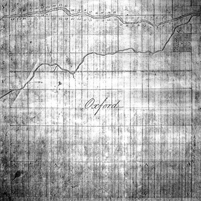
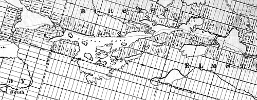
 Oxford Township - Then and Now
The top is a map based on Pennoyer’s survey of Oxford Township. The bottom is an accurate
township map. While the Rideau River is a bit different, partly due to flooding from the
Rideau Canal dam at Long Island, the glaring difference is Kemptville Creek. However, it
is interesting to note that the shape is pretty close, it’s just the geographic positioning
that is wonky (rotate Kemptville Creek counter clockwise in the top map and you’ll see
that its shape, while not exact, is pretty close to that of the actual creek as shown in the
lower image). It’s unclear how almost the right shape with a completely wrong geographic
positioning was achieved. Top: Map A22, Marlborough & Oxtford Townships, 1791, Archives of
Ontario, C-277-1-325-0-1. Bottom: section from United Counties of Leeds and Grenville, East Portion,
Ontario Ministry of Transport and Communications, 1993.
Oxford Township - Then and Now
The top is a map based on Pennoyer’s survey of Oxford Township. The bottom is an accurate
township map. While the Rideau River is a bit different, partly due to flooding from the
Rideau Canal dam at Long Island, the glaring difference is Kemptville Creek. However, it
is interesting to note that the shape is pretty close, it’s just the geographic positioning
that is wonky (rotate Kemptville Creek counter clockwise in the top map and you’ll see
that its shape, while not exact, is pretty close to that of the actual creek as shown in the
lower image). It’s unclear how almost the right shape with a completely wrong geographic
positioning was achieved. Top: Map A22, Marlborough & Oxtford Townships, 1791, Archives of
Ontario, C-277-1-325-0-1. Bottom: section from United Counties of Leeds and Grenville, East Portion,
Ontario Ministry of Transport and Communications, 1993.
Lt. Joshua Jebb, R.E. – 1816
Born in 1793, Joshua Jebb graduated in 1812 from the Royal Military Academy at Woolwich with the rank of 2nd Lieutenant. In the fall of 1813, he was promoted to 1st Lieutenant and sent to Canada where he was stationed in Lower Canada. He served under Sir George Prevost in the active campaign in the war with the U.S., including taking part in the Battle of Plattsburgh in the fall of 1814.
Although the war with the U.S. (the “War of 1812”) officially ended in late 1814, tensions remained very high. In 1815, the British Government ordered Lieutenant General Sir Gordon Drummond to make “estimates of expense of the Lachine Canal, and of the Ottawa and Rideau being made navigable.” One of the things they needed was a safe supply route to the vital British naval base at Kingston. In 1816, twenty-three year old Lieutenant Jebb was tasked with investigating the Rideau Route.
Jebb would have had a pretty good idea of the route prior to actually embarking on his survey. The initial township surveys had been done, roads penetrated into various parts of the Rideau and there were settlers scattered along the route. We don’t have any details about how Jebb travelled, what we have are his official reports to his superiors. It is likely that, similar to French, Jebb would have used birchbark canoes paddled in part by French- Canadian voyageurs and that he would have had men from the British Army to help with the survey.
Jebb was tasked with finding a navigation route, suitable for batteaux. The required navigation depth didn’t need to be more than 3.5 feet (1 m). The first hurdle was Rideau Falls – a vertical drop of 30 feet (9.1 m). Jebb had an interesting solution for this, to cut a ramp leading down to the Ottawa River on which wheeled carts could be winched up and down. He also didn’t see too many problems with making the Rideau River navigable. “The Idea which has hitherto prevailed that this place cannot be rendered navigable for batteaux is quite erroneous, since but few difficulties present themselves which cannot be easily surmounted.”
In his first reports (early June 1816), his favoured method for defeating rapids was to build a wing (a partial dam). This dam would extend partway out into the rapids, reducing the width of the river and so increasing the depth of the water. Batteaux could then be winched up the rapids, Jebb wrote, “the windlass described will afford very material assistance to boats in getting up.” He noted wings would be much less expensive than locks to construct and require far less maintenance. He did go on to say that the idea of wings “is a speculative idea of my own, and the effect of which I never had an opportunity of observing in practice.”
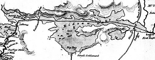
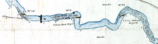 Wings and Dams
Three “wings” are shown on this map, one at Stegman’s Rapids (adjacent to Carleton
University), one at Three Rock Rapids (Hogs Back) and one at Three Island Rapids (now
drowned under the head of Mooneys Bay). The big bar at B might be a full dam and lock.
The numbers in the river channel represent depths (in feet) and the numbers on the banks
represent river current speeds (in miles per hour). Section from: “Plan of the Rideau River from its
Mouth to the Head of Long Island” by Lt. J. Jebb, July 8, 1816, National Archives of Canada, NMC 59324.
Wings and Dams
Three “wings” are shown on this map, one at Stegman’s Rapids (adjacent to Carleton
University), one at Three Rock Rapids (Hogs Back) and one at Three Island Rapids (now
drowned under the head of Mooneys Bay). The big bar at B might be a full dam and lock.
The numbers in the river channel represent depths (in feet) and the numbers on the banks
represent river current speeds (in miles per hour). Section from: “Plan of the Rideau River from its
Mouth to the Head of Long Island” by Lt. J. Jebb, July 8, 1816, National Archives of Canada, NMC 59324.
His idea of wings is absent in his later reports. In those reports he only mentions locks as a method for providing navigation around rapids. It may be that his superiors suggested that he stick to more traditional methods of making rapids navigable (i.e. locks and canal cuts).
Jebb conducted an amazing survey. He did it very quickly and by mid-July 1816 he had surveyed the entire Rideau system and produced a stunning map, incredibly accurate for the day. On the map, not only does he show a immense amount of geographic detail for the various rivers and lakes along the route, he also shows the roads and settlers’ houses. It’s a bit of a mystery how he was able to produce such an accurate map in so little time. One advantage Jebb had was that the fabric (lot and concession lines) of the township surveys would have provided many tie-in points. The later Rideau Route survey by Samuel Clowes would provide more accurate geographic detail than Jebb, but it took Clowes two years to do it and he had Jebb’s map in hand as a starting point.
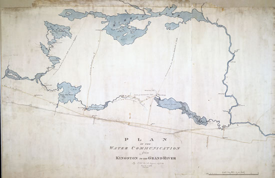 Jebb’s 1816 Rideau Map – Central Section
This shows both the Rideau Lakes Route and the Irish Creek Route short-cut. “Plan of the
Water Communication from Kingston to the Grand River” by Lt. J. Jebb, July 8, 1816, Libraries and
Archives Canada, NMC 21941 2/3.
Jebb’s 1816 Rideau Map – Central Section
This shows both the Rideau Lakes Route and the Irish Creek Route short-cut. “Plan of the
Water Communication from Kingston to the Grand River” by Lt. J. Jebb, July 8, 1816, Libraries and
Archives Canada, NMC 21941 2/3.
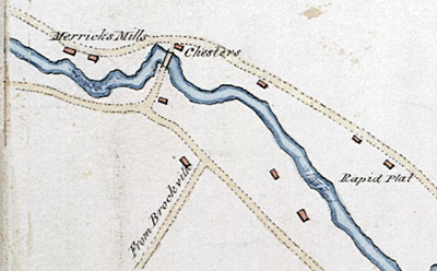 Merrickville Area 1816
This image illustrates the level of detail in Jebb’s map.
Section from “Plan of the Water Communication from Kingston
to the Grand River” by Lt. J. Jebb, July 8, 1816, Libraries
and Archives Canada, NMC 21941 3/3.
Merrickville Area 1816
This image illustrates the level of detail in Jebb’s map.
Section from “Plan of the Water Communication from Kingston
to the Grand River” by Lt. J. Jebb, July 8, 1816, Libraries
and Archives Canada, NMC 21941 3/3.
One can image Jebb as a very energetic young man, and even though his wings had been clipped, he continued to be full of new ideas. The one he is remembered for the most today is his recommendation that the navigation route between the Ottawa River and Kingston be taken by way of Irish Creek rather than through the Rideau lakes. In his investigations of the region, he realized that going by way of Irish Creek (just south of Merrickville) and then up and over the watershed divide into Upper Beverley Lake and from there back to the Rideau through White Fish Falls [Morton] would cut off a great deal of distance.
There was a minor problem with his suggestion, a distinct lack of water at the top of the Irish Creek watershed. However, this wasn’t a problem for Jebb’s fertile mind, he envisaged building a five mile (8 km) long rail road to connect the two sections of navigable water. Goods would be offloaded from one batteau, transferred across the divide by rail, and then loaded onto another batteau for the journey to Kingston. “I would construct a rail way using a particular description of low cart for transporting stores to where the water communications again commence.” In his report he noted that the cart “is usually made of cast iron, which would be easily obtained and brought by water, if Government would again Occupy and work the furnace on the Gananoqui Stream. The finest ore is in abundance on the spot, and I need not advert to the advantages in an economical point of view that would result from such an establishment in every article of Iron work.” Jebb was suggesting that the iron works at Lyndhurst, which had burnt down in 1811, be re-opened.
In the end, Jebb’s survey was not acted upon. It would be another 10 years before the construction of a navigable waterway along the Rideau Route was to start.
Samuel Clowes – 1823 & 1824
Samuel Clowes was a civil engineer hired by the Macaulay Commission (set up under an Act of the Provincial Legislature to investigate internal navigation in the province of Upper Canada) to survey and prepare cost estimates for the Welland and Rideau canals. He surveyed the Welland in 1822 and then started surveying the Rideau Route in 1823. He was born in about 1766, so he would have been in his late 50s when he surveyed the Rideau.
Clowes’ survey of the Rideau Route started with a reconnaissance tour of the entire region. For this trip he was accompanied by his son James, Provincial Land Surveyor Reuben Sherwood (acting as a guide), and one of the commissioners (unnamed) of the Macaulay Commission. Sherwood had already done several local township surveys in the early 1800s, such as those of South Crosby, North Crosby, and Pittsburgh townships. He would have been able to provide a lot of local knowledge about the geography of the region. For this first trip they “embarked in canoes early in the Spring and proceeded from Kingston up the Grand River Cataracquay.” They travelled up through the Rideau lakes, into Lanark County to Perth and then over to the Mississippi River, then back along the Ottawa River to the Rideau River, up the Rideau River and back to Kingston.
With this reconnaissance survey done, a route by way of the Mississippi River was discounted. Clowes also mentioned that the Petit Nation River [South Nation River] was contemplated but not investigated. It was determined that the route by way of the Rideau River was the one to be fully surveyed. The commissioners also suggested to Clowes “that he would probably meet with the lowest summit at a place in the Township of Kitley, called Plum Hollow, where the waters of the Rideau and Gananoque very closely approach each other.” They had obviously read Jebb’s report and his recommendation for the Irish Creek route.
In early June 1823, Clowes started his formal survey. He would likely have had several men in his survey party, but he only specifically named two of them in his report, stating “aided as he [Clowes] was by the zeal and assiduity of his assistant, Mr. James Clowes, and of the land surveyor, Mr. Reuben Sherwood.”
By this time the region was more populated than it had been during Jebb’s survey. New mills had been built, such as those at Brewer’s, Davis’ and Chaffey’s rapids, small communities were growing and more people were homesteading in the district. So this made the logistics of doing a survey much easier – local shelter and provisions could often be obtained.
However, the type of survey Clowes was doing was different than those done previously. Clowes was running levels, measure the elevations along the route. He was also chaining (measuring exactly) distances along the entire route.
We don’t know the exact equipment that Clowes used but we can guess. For distance, he would have had a Gunter’s chain, a metal chain, 66 feet long, with 100 links. He reported distances in miles and chains (80 chains to the mile). For angles and levels it is likely he used a theodolite, a survey instrument with a telescopic sighting device that could be used for measuring angles and calculating levels. This would have been accompanied by a survey rod, a stick marked out in feet.
Although Clowes reported levels to two decimal places (i.e. 7 feet 45 decimals = 7.45 feet), due to the conditions he was surveying in, actual accuracy was far less than this. Surveying through the Canadian bush was challenging. For angles and levels you need a clear line of sight. Horizontal measurements (as opposed to slope measurements) needed to be taken, usually accomplished by holding the chain level and by “breaking chain” (measuring in small horizontal increments) on steep slopes. An additional difficulty was that Clowes wasn’t just following one route, he was examining all the various options for where locks and canal cuts might be placed.
In his 1823 report he wrote “From the rugged and broken nature of these parts of Pittsburgh and South Crosby [townships], through which the various levels were conducted – from the numberless rocky eminences, marshes, bogs &c. every where encountered, and from the scanty information to be gained in any other way than by personal examination of a tract of country, which still remains almost in its primitive state, there unavoidably resulted much delay and occasional perplexity.”
This type of detailed survey took time. Clowes reported “the Engineer [Clowes] began to explore the Level on the 12th day of June and continued incessantly engaged with it until the 15th day of November, when the severity of the weather and the necessity of reporting on the progress of the survey, put a period on his operations.” In the 1823 season he had been able to survey from Kingston to Rideau Lake and then do a quick run of levels down to the Ottawa River.
 Clowes’ Map – Central Section
“Sketch of the Water Communication from Kingston to the Grand River” by Samuel Clowes, 1823-24,
Library and Archives Canada - NMC 11962.
Clowes’ Map – Central Section
“Sketch of the Water Communication from Kingston to the Grand River” by Samuel Clowes, 1823-24,
Library and Archives Canada - NMC 11962.
The lakes that he encountered presented a significant problem. You could measure distances and angles around the lakes and through triangulation figure out the exact dimensions of the lake. But this was a long and difficult process. In his 1823 report he wrote “The distances here computed, it may be remarked, are not perfectly correct, as several of the lakes which were never accurately surveyed could not be conveniently measured during summer. This operation was therefore deferred until the ice should afford an opportunity of accomplishing it with greater facility, accuracy and dispatch, and the Land Surveyor is now engaged in its execution.”
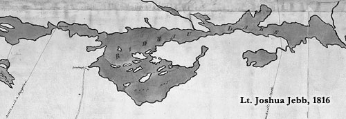
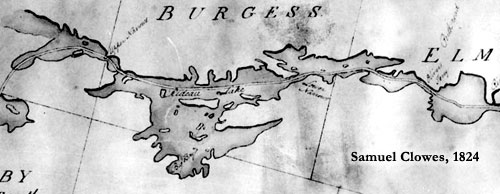
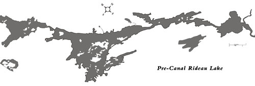 Rideau Lake
In the pre-canal era, there was a just a single Rideau Lake. The bottom image is a present
day reconstruction of what the original Rideau Lake looked like. While Clowes’ 1824 map
is more accurate that Jebb’s 1816 map, Jebb’s map is very good, especially considering the
time period of his survey. Sources op. cit. Diagram by Ken W. Watson.
Rideau Lake
In the pre-canal era, there was a just a single Rideau Lake. The bottom image is a present
day reconstruction of what the original Rideau Lake looked like. While Clowes’ 1824 map
is more accurate that Jebb’s 1816 map, Jebb’s map is very good, especially considering the
time period of his survey. Sources op. cit. Diagram by Ken W. Watson.
Clowes was also checking the character of the land at each potential lock site and canal cut: “... the Engineer has bored the ground wherever excavation would occur to the depth of the bottom level of the Canal, and has thus accurately ascertained the nature of the various strata of earth and rock along the whole line.”
Clowes and his survey party returned in 1824 to complete their survey down to the Ottawa River. The route he proposed was by way of the Rideau lakes. He discounted Jebb’s Irish Creek route for a number of reasons. One was that his survey found that it was not lower than Rideau Lake, so the same number of locks would be required.
But, most importantly, there was no water. Clowes was tasked with providing a fully navigable waterway, with a navigation depth of either 4, 5 or 7 feet. So, water was needed at the top of the Irish Creek route and the only way Clowes could see getting it there was to dig a 10 mile (16 km) long feeder canal from Rideau Lake. Clowes’ conclusion was that it would be much cheaper to go by way of Rideau Lake.
Clowes left several lasting legacies in terms of mapping and canalizing the route. The first of course is that his choice of a route through the Rideau lakes was the one that was followed. Clowes fully discounted the Irish Creek route and it appears that based on Clowes’ work, Colonel By never even considered it as a possible route. The decision to go by way of the Rideau lakes had been made by Ordnance before Colonel By was even appointed Superintending Engineer for the Rideau Canal project.
While Clowes’ was suggesting a conventional canal, with cuts around the rapids and a tow path along the route, in the area of the Cranberry Marsh he saw the effectiveness of providing navigation by flooding (the slackwater system). He observed that the two existing mill dams, one at White Fish Falls (Morton) and one at the Round Tail (near Upper Brewers) were providing a navigable depth of water through a previously unnavigable section. So, he recommended that these mill dams could be converted to canal dams at a far lower cost than digging a ditch from Upper Brewers to Jones Falls. Clowes’ report may well have been the seed that convinced Colonel By to build the entire Rideau Canal as a slackwater system.
Finally, Clowes left us with the most accurate pre-canal era map of the Rideau Route. While it contains many inaccuracies, it was remarkable given the difficult conditions Clowes was working under.
The Final Route of the Rideau Canal
The final route of the Rideau Canal was decided in England before Lt. Colonel John By ever caught sight of the Rideau. In a memo to General Mann on March 14, 1826, Major General Sir James Carmichael Smyth wrote:
“2.—Strong representation will be made to Lieut.-Colonel By by many respectable inhabitants and several of the principal merchants, recommending that Canal to be conducted by Kyles Bridge [Koyles Bridge on the Irish Creek Route], as being the nearest line, and requiring only a very short land-carriage ; others will propose the Ganonquée River, instead of Kingston, as the most convenient termination of the Canal on Lake Ontario. In a point of view, these considerations might be worth attending to : as it is, however, an uninterrupted Water Communication between the Ottawa and Lake Ontario the Government have in view, and the circulation of gun-boats between Montreal and Kingston. The Canal will have to be conducted by the Rideau River, the Rideau Lake, the Mud Lake [Newboro Lake], Cranberry Marsh, and Kingston Mill-Stream [Cataraqui River].”
Major General Smyth clearly set the route to follow as that by way of the Rideau lakes. He then went on to apprise Colonel By of some of the resource material he should obtain:
“3.—Lieut.-Colonel By is recommended to procure at Quebec, at the Commanding Engineer’s Office, a copy of Lieutenant Jebb’s Report upon the subject, and also a copy of his sketch of the ground : he will find both these papers very clear and satisfactory ; he will, however, derive more detailed information from the Report of the Parliamentary Commissioners of Upper Canada, of the 5th February last, addressed to Sir Peregrine Maitland, and giving cover to three estimates for forming the Canal under consideration, drawn up by a very able practical civil engineer, Mr. Samuel Clowes, from actual survey and measurement. A copy of this Report, and of these estimates, Lieut.-Colonel By will be able to procure upon application at the proper office at York, and doubtless they will afford him very great assistance.”
The stage was now set for Colonel By. The route would go from the Ottawa River to Kingston by way of the Rideau River, the Rideau lakes, Cranberry Marsh and the Cataraqui River.
In the late summer of 1826, when Colonel By arrived at the present day location of Ottawa, it didn’t take long to determine the starting point of the Rideau Canal. Jebb and Clowes had both assumed it would start at Rideau Falls. There had been some earlier talk of starting at LeBreton Flats, which would have allowed a wider spacing (although the same number) of locks – but Lord Dalhousie considered the price of that land too high. In the end,what is known today as Entrance Bay (or Colonel By Bay) was chosen.
For the rest of the route, Jebb and Clowes had already mapped out the rapids and waterfalls, locations where dams and locks would have to be placed. Colonel By travelled along the Rideau in the fall of 1826, in the company of Samuel Clowes, who pointed out all the details. In some cases it was fairly easy to determine lock and dam placement, in other places, such as Smiths Falls, to quote a later statement by N.H. Baird, it “was a bit of a puzzler.”
Samuel Clowes appears to have been the last man to do a full survey of the Rideau prior to its opening in 1832. The system-wide maps produced during the construction of the canal do not show any more detail than those provided by Clowes and Jebb, in fact, in several we see elements of their mapping.
Colonel By really only needed to know a few things: how high could he make his dams (how much the topography of the surrounding countryside could impound the water); how much land was going to be flooded (to pay compensation); the navigation depth between each lock site (to ensure a minimum 5 foot navigation depth) and the level of the lower sill of one lock in reference to the upper sill at the next lock (and vice-versa). Ideally those two levels would be exactly the same, and, with only a few exceptions, he succeeded in obtaining this accuracy to within a few inches.
One of By’s most useful and extensively used survey tools was flat water. He used existing mill dams at several sites to judge levels and in some cases had temporary dams built to see the effect of raising the water. This saved a lot of detailed instrument surveying. However, in several areas such surveys had to be done. The officers of the Royal Engineers working under Colonel By, such as Lt. Denison, Lt. Frome, Lt. Pooley and Captain Victor, were all trained in surveying. We see their names appear on several detailed maps of sections of the route.
Two Canal Construction Era Maps showing Rideau Lake
The top map is dated 1830 and signed by Colonel By. It is inaccurate and appears to show
many elements taken from Jebb’s 1816 map. The lower map dates to between 1828 and
1830 and is made up of compiled township survey maps. By this time, most townships had
been surveyed at least twice, sometimes more. You’ll note much better geographic detail for
Big Rideau Lake in North and South Burgess townships than in Bastard Township.
Top: “Plan of the Line of the Rideau Canal Showing the Section of Each Work” by Lt. Colonel John By,
July 8, 1830. Library and Archives Canada, NMC 43041 . Bottom: part of Plans No. 1. to 4. Shewing the
Waters by which the intended Route of the Rideau Canal is to pass by John By; Thomas Ridout; E.W.
Durnford, c.1828-1830, National Archives of Canada, NMC 130125.
Colonel By also had the services of civilian surveyors. Two in particular are notable, John Burrows and John Mactaggart, not only for the work they did, but for the information they recorded about their surveys.
John Burrows – 1827
In 1827, John Burrows conducted two surveys along the full length of the Rideau Route, accompanied by some of the junior Royal Engineers, and, on the second survey, also accompanied by John Mactaggart. These surveys were done to sort out some of the final issues with lock and dam placement.
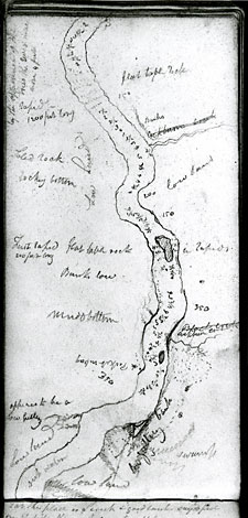 |
| Burrows’ Survey Diary
A page from Burrows’ 1827 survey
diary (a section between Smiths Falls
and Poonamalie) showing the type of
information he was recording. John Burrows’
Survey Diary, City of Ottawa Archives,
C52958. |
Born in England as John Burrows Honey in 1789, he immigrated to Canada in about 1815. By 1817, he had settled in Nepean (now part of present day Ottawa). He qualified as a land surveyor in Hull, Lower Canada, in 1820. He was taken on as an Overseer of Works for the Rideau Canal project in March 1827. Colonel By was to make extensive use of Burrows’ surveying and map-making skills.
Burrows’ survey diary of his May survey contains many sketches. These aren’t detailed survey maps, rather they are simple sketches, designed to augment his written text. In some he is simply illustrating features of the landscape, in others he is showing soundings (depths) of the channel.
He had Clowes’ map and reports at hand, he makes reference to them many times. His diary starts on May 11, 1827, when he writes “Started at ten o’clock from Captain Wilson’s [just upstream from Hogs Back] in five canoes.” They had lunch at the head of Long Island, leaving there just after 2 pm and arriving at Kemptville Creek just before sunset. It was raining and Burrows wrote “Nothing like a stimulus of rain to quicken the motion of the paddle or to awaken the vocal powers of the Canadian boatman.” This reflects the use of French-Canadian voyageurs as the paddlers and their normal practice of singing boat songs as they paddled. Burrows noted that they were still eight miles short of their intended destination of Burritt’s Rapids and they decided to continue on. “Rum renewed the men and, singing, pulling and striving for the lead of canoes” they arrived at the house of Mr. Hurd (just downstream of Burritt’s Rapids) by 9:15 pm.
While most of the Rideau Route documents that we have today are matter-of-fact reports, Burrows, likely because he was writing in his own survey diary, noted things outside of the immediate task of conducting a survey. As they neared First Rapids (Poonamalie) he wrote “Here with pleasure we behold the instinct displayed by a little squirrel in sailing across the river, his tail acting as a sail, seemed to be the principal part used to propel it forward.”
They took the opportunity to fish as they travelled, noting near the mouth of the Tay River “Caught 2 black bass with line hanging to the Canoe.” Burrows said in a later survey that “Fish in great plenty is at all times caught by the inhabitants and becomes a great relief to salt provisions.” The main salt provision for both the local inhabitants and the surveyors was salt pork, a staple of the diet of the day.
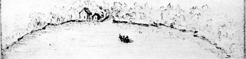
On entering Lower Rideau Lake he wrote, “The entrance into the lake is indescribably beautiful. Its surface as smooth as a mirror. The banks delightfully dispersed with opening buds of spring reflected on the surface of the river. In front on a projected point a beautiful appearance of a dwelling house. The whole enlivened and softened by the rising sun.”
They overnighted at Davis’ Mill and then rose at 4 am to start their day by portaging the canoes past the rapids and putting into Sand Lake. Burrows’ writes “The view of Davies Lake [Sand Lake] is very pleasing. The many islands, as if floating on a transparent mirror which mellowed and reflected by the tint of the morning, strikes the contemplative mind with a sensation of pleasure not easily forgotten.”
At 6:30 am they landed at the head of the portage around Jones Falls rapids, Burrows taking the opportunity to walk down the east bank of the rapids “The view of the Falls is awfully grand: the banks being very high and close. Some places are only chasms of 200 and 300 feet deep. It may be possible to make locks only by building piers and hanging gates.” His estimates of the depths of the canyon are a bit exaggerated, the maximum vertical difference he would have actually seen (top of hills to water) was in the order of 125 feet (still impressive).
Below Jones Falls he entered into the Drowned Lands – forests drowned by the mill dams at White Fish Falls and the Round Tail. Burrows wrote “Our canoes sailing through the openings of the trees, and, from the innumerable windings and curves, the route is very difficult to find.” During his second survey, in July 1827, they got lost in the Drowned Lands (his story of that incident and a similar story by John Mactaggart are detailed in the John Mactaggart section).
On his second 1827 survey, Burrows was accompanied by John Mactaggart and three Royal Engineers (Lt. Frome, Lt. Smith and Lt. Wallis). By this time, work had started in earnest at several lock sites. At Black Rapids, Burrows noted: “Mr. Phillips and White have made a respectable beginning at this place, having cleared off the whole of the line, built two large log houses, opened a fine quarry, and cut no small quantity of stone for the locks.”
The work on building the Rideau Canal had already begun. With this second survey, Burrows, Mactaggart and the Royal Engineers were now looking at the specific details of each lock site, confirming plans at some, working up new plans at others.
John Mactaggart – 1826 & 1827
The following two surveying stories are taken directly from the book “Three Years in Canada,” by John Mactaggart, 1829. In Mactaggart’s writings, it’s a little difficult to separate fact from fiction. He had a fertile imagination and some of what he writes appears to be embellished. His second story, of being lost in Cranberry Marsh (the drowned forests of the Cranberry Flood Plain) with Colonel By, has echoes in a similar story written in the survey diary of John Burrows (which is described at the end of the Cranberry Marsh story).
Mactaggart was born near Kirkcudbright, Scotland in 1791. He is described as being “a handsome man of 6 feet 2 inches, and of stout figure, his proportions being majestic.” The exact training he might have had as an engineer is unknown, but he was recommended to Colonel By by the son of the famed Scottish civil engineer, John Rennie. He was appointed to the important position of Clerk of the Works in August 1826, at the age of 35. He was fired in the summer of 1828, for being drunk while on duty, by Governor Sir James Kempt and was replaced by Nicol Hugh Baird. Mactaggart didn’t seem the intemperate sort, but he was known at times to be disrespectful to authority and that is likely what got him in trouble. Within a year of returning to England he had published his book, Three Years in Canada, a 2 volume work covering a wide range of topics. He died in January 1830.
In the fall of 1826, one of the issues that needed to be resolved was how to get from the chosen starting location, Entrance Bay, to the Rideau River. To figure out the exact lay of the land, John Mactaggart was tasked with surveying this area. Part of it was covered by Dows Great Swamp, which presented many difficulties for anyone that wanted to conduct a survey.
Christmas in the Bush by John Mactaggart
“When I first arrived at the Rideau, the Governor of Canada, Lord Dalhousie, and Colonel By, were there, and had fixed the entrance of the Rideau canal to be in Rafting Bay ; a beautiful bay about two miles farther up the Ottawa river than where Mr. Samuel Clowes, Civil Engineer to the Provincial Government of Upper Canada, had proposed, as being the only practical place where the Rideau river could be carried into the Ottawa by a canal. Accordingly, my first duty seemed to be that of proving if the said engineer was right or not; Rafting Bay being by far the most elegant entrance for the canal, and nearer the head of the Ottawa navigation.
Having procured three faithful men to assist me to explore, as many axe-men, and two to carry provisions, we sallied out into the woods in the beginning of November 1826. The axe-men continually cutting down a line through the underwood, we were enabled to take, what is called in surveying, a flying level, which is a rough guess to a foot, more or less, of the rise or fall of the country above any fixed data. Having continued at this fagging employment for three days, my assistants keeping in the neighbourhood, returning nightly and giving information respecting swamps, gullies, streams, mountains, &c. I at last came upon the famous Rideau, at a distance of between four and five miles from the above beautiful bay.
Taking a level of this extent in England would not have occupied more than a day; but in a dark dense wood the subject is quite altered, and a surveyor has to change his home system altogether : for instance, if we get upon a hill or other eminence in Britain, we may see the natural lead of the land; but in Canada, owing to the wilderness, you have to grope for this like blind men. On coming out on the river, I found it to be forty-five feet above the level of the Ottawa, and that if a cut were to be made from thence to the valley which descended into the bay, a rocky ridge would have to be broken through, nearly two miles long, and about sixty feet deep to the bottom level of the canal. To attempt such a work would have been madness: the thing is by no means impracticable, but it would devour an enormous sum of money. Finding this, we left behind our various scientific instruments, and ascended the river.
Having penetrated about three miles, we came upon foaming rapids, where the river was narrow in width and the banks high. Here was the famous Hog’s Back, and here we proposed to raise the river by a dam, so that the water might be brought on a level with the head of Entrance Valley above alluded to, which was eighty feet above the Ottawa. But the question arose again, if the river could be raised here to the required level, was it possible for us to retain that level through the wilderness,—a distance, as we supposed, of seven miles? To ascertain this, now became the object of research, and we set to work accordingly ; but meeting with various gullies, and huge swamps, to get through which (they being full of water) became almost impossible, we waded, and were often obliged to crawl on our hands and knees under the brushwood, and this in water.
Finding, therefore, we could make no good job of surveying them, until the swamps froze, we wended our weary way to the Ottawa as we best could, and there awaited the coming of the frost, which did not happen sufficiently for our purpose until the 20th of December, and then it was accompanied by a foot-depth of snow. No matter ; we started again, cut holes through the thickets of these dismal swamps, directed a person to go about half a mile before, and wind a horn, keeping to one place, until those behind came up; so that by the compass and the sound, there being no sun, we might better grope out our course. For in the woods you have not only to keep to a course, but you have also to discover what that course is; not as on sea, where the course is known, before the ship starts, that one port bears from another; but in the wilderness the relative position of places is not known,—a cause which improves the instinct of the Indian, making it so superior to that of a European. We had this matter to study deeply; and we had likewise to seek for that track where we could best preserve our level, in the shortest possible distance. This compelled us frequently to diverge from the direct course; a ridge of rocks or a deep swamp, the one much above, the other beneath, the required level, had necessarily to be shunned as much as possible.
I mention these things out of no vain boast, but as curiosities in science, and must own that the subject perplexed me not a little. Placed in thick and dark snowcovered woods, where, unless the axe-men cut holes, a prospect of five yards could not be obtained ; doubtful what kind of land lay on either side, or directly before ; calculating at the same time, the nature of canal-making in such places, the depths to dig, or the banks to raise, so that the level might be kept from one sheet of water to another, the former eighty feet above the latter; while the weather was extremely cold, and the screws of the theodolite would scarcely move: these things all considered, were teasing enough to overcome, and required a little patience.
When night drew on, two of the axe-men were sent off to rig the wigwam shanty by the side of a swamp. This was done for two reasons, or say three : first, because water could be had in the swamps to drink and cook with, if the ice were broken to get at it; secondly, the boughs of the hemlock grow more bushy in such places, and are so far more easily obtained to cover the shanty ; and thirdly, there are generally dry cedar-trees found there, which make excellent firewood, and the bark of dry cedar is the best thing in the world for lighting a fire with. When the party got to the place, there was a very comfortable house set out, a blazing fire with a maple back log, ranging along for a length of twenty or thirty feet.
There, on the bushy hemlock would we lie down; roast-pork before the fire on wooden prongs, each man roasting for himself; while plenty of tea was thrown into a large kettle of boiling water, the tin mug was turned out, the only tea-cup, which being filled, went round until all had drunk ; then it was filled again, and so on ; while each with his bush-knife cut toasted pork on a shive of bread, ever using the thumb-piece to protect the thumb from being burned : a tot or two round of weak grog finished the feast, when some would fall asleep,—others to sleep and snore ; and after having lain an hour or so on one side, some one would cry Spoon!—the order to turn to the other—which was often an agreeable order, if a spike of tree-root or such substance stuck up beneath the ribs.
Reclining thus, like a parcel of spoons, our feet to the fire, we have found the hair of our heads often frozen to the place where we lay. For many days together did we lie in these wild places, before we could satisfy ourselves with a solution of the problem already represented. In Dow’s great swamp, one of the most dismal places in the wilderness, did five Irishmen, two Englishmen, two Americans, one French Canadian, and one Scotchman, hold their merry Christmas of 1826,—or rather forgot to hold it at all.”
From “Three Years in Canada,” Vol.1, pp.48-53
The next story is about being lost in the Cranberry Marsh. The term “marsh” is a bit of a misnomer, Mactaggart is actually referring to the Cranberry Flood Plain, a 13 km (8 mile) long stretch between the White Fish River and the Cataraqui River. Today this is the area occupied by Whitefish Lake, Little Cranberry Lake and Cranberry Lake. Originally, the landscape consisted mostly of forest, with some marshes, streams, ponds and one small lake. It was above water for most of the year and formed a navigation barrier.
At some point between 1803 and 1805, brothers Lemuel and Carey Haskins erected a dam at White Fish Falls (today’s Morton) in order to power a sawmill. This flooded water over the Cranberry Flood Plain, sending it south to the Cataraqui River. Sometime after 1803-1805, but prior to 1816, they erected a second dam, this one at the Round Tail (just north of Upper Brewers). The combination of these two dams put about 6 feet (1.8 m) of water over the Cranberry Flood Plain, drowning all the forests. It was this drowned forest land that now caused significant navigation difficulties for the canal surveyors – large areas of dead standing trees through which canoes had to navigate. This is the reason that both Mactaggart and Burrows report getting lost in this area.
As a side note, his use of the term “craneberry” in the following story is correct. The word “cranberry” is derived from this earlier spelling of the name. In his book, Mactaggart uses both spellings.
Lost in Cranberry Marsh by John Mactaggart
“In some of my curious wanderings I was accompanied by Colonel By, of the Royal Engineers, a gentleman I shall ever esteem and value. He encountered all privations with wonderful patience and good-humour; was even too daring in some instances; would run rapids that his Indians trembled to look at; and cross wide lakes with the canoe when the Canadians were gaping with fear at the waves that were rolling around them. He could sleep soundly any where, and eat any thing, even to raw pork.
One night we lost ourselves altogether in Craneberry Lake, on our route through the waters from the Ottawa to Lake Ontario. There were two canoes of us, and the poor fellows paddled away lustily ; but it was of no use ; the more we sailed, the farther astray we went, and could not find the outlet of the river Cataraque. Getting through a frightful marsh, partly overflowed by water, we entered with the canoes into an expanse of flooded woods, and one of the canoes stuck in the fork of a tree buried in the water. We went alongside, and the crew having got into the other canoe, we succeeded in lifting it out of the fork. Dark night came on, and we landed on some sort of wild shore about ten o’clock, clambered up the brow amongst the trees, and pulled the canoes and their cargoes after.
We had parted with our provision canoe on the morning before, and appointed to have met with it that night at a station called Brewer’s Mills: thus we had nothing to eat but a small bit of cheese ; and as for drink, there was nothing but a little drop of brandy in a bottle, and this was not allowed to be touched. There we were, no one knew where, in the heart of an endless wild, without food or any thing else whatever for the comfort of human life ; but we minded it not. Although we had had a fagging day, no one was inclined to sleep: could we have knocked up any thing in the shape of a dinner, we might then all have snoozed profoundly ; but hunger kept us from the arms of Morpheus, and allowed us to ruminate on our forlorn situation. We hallooed out frequently as loud as we could, but no one heard us. We were sometimes answered by the owl, afar in the solitary woods, and the lake bird, called loon, also deigned to reply from the distant waters. At one time we heard, or thought we heard, the barking of a dog,—which might have been so, but I thought it that of the wolf species.
Having a gun with us, we succeeded in lighting a good fire, which is always a pleasant thing to look at; while the light reflected aloft on the woods was beautiful. We frequently loaded the gun with powder and fired it off; and the sound reverberating through the forest and rocks was heard for a long time after. Thinking we had got into Loughborough Lake, which opens out of Craneberry Marsh, towards morning we started with the light of the moon, and after paddling away five or six miles until we came to the head of a deep bay, swimming-full of driftwood, we there put about, and were glad to get back to the fire we had left on the unknown shore. We had supplied it well with fuel before we started, in hopes that we might use its light, like that of a Pharos, to guide us on our proper course ; but, alas! we now all began to droop a little, for there was a probability that we might not find our way out of the Lake, and of course, therefore, must perish.
The sun arose ; we took to the canoes again, and seeing some wild ducks, we shot at them several times, but could not succeed in killing one of them. Having paddled away several miles, and taking our bearing by the sun, the compass being useless, I found we were returning as we had come the day before; we therefore lay to, to strike the course. While doing so, we heard the report of a musket at a distance. We bore away to the place whence the sound proceeded, heard another shot let off, and even saw the smoke. It was an Indian shooting wild ducks. We all felt rejoiced to see him, divided the drop of brandy, engaged him as a guide, and he brought us out at the famous Round Tail mouth of the Cataraque; from whence we proceeded to Brewer’s Mills, found the provision canoe, and made a hearty breakfast. So much for that time when I was bewildered in the Craneberry Marsh; but it was by no means the first time. I had spent many dismal nights in it before, and only narrate this on the score that Colonel By was with me, and conducted himself as became a man.”
From “Three Years in Canada,” Vol.1, pp.54-58
This story, while it may be perfectly true, has echoes of the survey diary of John Burrows where he describes a survey trip in late July 1827, which included John Mactaggart. Burrows stated that he was the only member of the party who had previously been through the Cranberry Marsh, so that would have made it Mactaggart’s first trip through this area. Burrows wrote that they got lost, overnighted in the marsh, found a guide the next day and made it to the Round Tail (similar elements to those in Mactaggart’s story).
Burrows stated that they left Jones Falls near sundown (on July 31, 1827) and entered into the Cranberry Marsh but were “much incomoded by fallen trees and floating logs.” He then went on to note that his own recollection of his first passage through these drowned lands (in May 1827), plus the township map of Reuben Sherwood and the route map of Joshua Jebb didn’t help them. He wrote “and in the light of each of these helps we found ourselves in an error and shut into a long narrow bay having much the appearance of an outlet from the drowned lands into Cranberry Lake, but this appearance proved erroneous. By studying the two plans in our possession the differences between them was more calculated to mislead than direct.” They went to shore and camped overnight. The next day they regained the route and found another member of their party who directed them to some nearby farms. There they found someone to guide them and, with that help, continued without incident to the Round Tail.
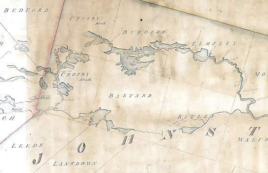
The Rideau Route – 1832 to Present
Later 1800s maps show no improvement over what Jebb and Clowes produced. An 1851 Ordnance map of the entire Rideau Route still showed inaccurate representations of the lakes. The County Atlas maps produced by H.R. Walling in the 1860s and 70s show similar inaccuracies (although in fairness to Walling, his main intent was to show the lots, concessions, roads and the names of residents).
 County Atlas Mapping
The shapes of the lakes in the County Atlas Maps of the 1860s weren’t very accurate. Maps
by Henry F. Walling, Counties of Leeds and Grenville, Canada West, 1861-62. From digital.library.mcgill.
ca/countyatlas/
County Atlas Mapping
The shapes of the lakes in the County Atlas Maps of the 1860s weren’t very accurate. Maps
by Henry F. Walling, Counties of Leeds and Grenville, Canada West, 1861-62. From digital.library.mcgill.
ca/countyatlas/
In the 1800s, navigation of the Rideau Canal, which was mostly commercial, depended on learning the route first hand by travelling it – not by picking up a map to figure it out. So there really wasn’t a demand for a navigation map. But with increasing recreational use, that demand started to grow. In 1872, the Department of Public Works recommended that a survey be done to produce a navigation map of the waterway.
The first map available to the public appears to have been a black and white photographic print of a sketch map used by the Department of Railways and Canals. In 1905, Superintending Engineer of the Rideau Canal, Arthur T. Phillips, ordered 150 of these to be made and they were sold at $1 each. In subsequent years however, Phillips had no interest in supplying a navigation map of the route to the public, and no further maps were issued.
The first readily accessible commercial map and guide was that of Dr. Elmer J. Lake, who produced three editions of his “Dr. Lake’s Chart of The Rideau Lakes Route” (1907, 1911, and 1920). In his guide he had quite accurate sketch maps and Lake also provided all the navigation details a boater needed to be aware of along the route.
In 1921, Henri Melancon, an employee with the Hydrographic Survey Branch of the Department of Naval Services in Ottawa, produced a chart for sale (which he sold privately). By 1929, he was selling this as “The Blue Chart, Aid to Yachtsmen, The Rideau River Route.” This map, at about 1:50,000 scale, showed excellent accuracy in the outlines of the lakes and rivers along the Rideau Canal. The Rideau Canal Office also had very detailed maps of the lakes and rivers at this time, but a direct comparison of some of these to Melancon’s map shows differences (so Melancon was using different mapping data than that used by the Rideau Canal Office).
 Early 20th Century Navigation Maps
The upper map is taken from the 1920 edition of Dr. Lake’s Chart of the Rideau Lakes Route.
It shows quite an accurate representation of Big Rideau Lake. The lower map is the 1929
Blue Chart by Henri Melancon. The Blue Chart is a bit more accurate than Dr. Lake’s chart,
although both provided excellent navigation guides (Dr. Lake included a written description
of the route in addition to the maps). One change of note, is that German Bay on Dr. Lake’s
Chart had become Briton Bay on Melancon’s chart, a reflection of feeling towards Germany
after WWI. Top: Chart of the Rideau Lakes Route Between Kingston and Ottawa, Kingston, 1920 by
Elmer J. Lake, p.32. Bottom: “Blue Chart” Aid to Yachtsmen, Rideau River Route, Ottawa to Rideau Lake
(1) Rideau Lake to Kingston (2) by Henri Melancon, 1929, Library and Archives Canada, 43047.
Early 20th Century Navigation Maps
The upper map is taken from the 1920 edition of Dr. Lake’s Chart of the Rideau Lakes Route.
It shows quite an accurate representation of Big Rideau Lake. The lower map is the 1929
Blue Chart by Henri Melancon. The Blue Chart is a bit more accurate than Dr. Lake’s chart,
although both provided excellent navigation guides (Dr. Lake included a written description
of the route in addition to the maps). One change of note, is that German Bay on Dr. Lake’s
Chart had become Briton Bay on Melancon’s chart, a reflection of feeling towards Germany
after WWI. Top: Chart of the Rideau Lakes Route Between Kingston and Ottawa, Kingston, 1920 by
Elmer J. Lake, p.32. Bottom: “Blue Chart” Aid to Yachtsmen, Rideau River Route, Ottawa to Rideau Lake
(1) Rideau Lake to Kingston (2) by Henri Melancon, 1929, Library and Archives Canada, 43047.
After WWI, a new survey technique started to be employed, the aerial photograph. This evolved over time to use aerial photos, in conjunction with land based tie-in surveys, for fast, highly accurate map-making. These new maps included topography, the contours of the land. But one thing that boaters wanted were the depths under the water. They wanted a hydrographic chart, one that not only showed accurate outlines of the route, but one that also showed the depth of the water.
By the early 1950s, hydrographic charts of the Rideau Canal were available – Chart 1575, “Kingston to the Narrows Lock” and Chart 1576, “The Narrows Lock to Ottawa.” The last edition of these was produced in 1967. In the early 1970s, two new, more detailed charts were produced, Chart 1513 from Kingston to Smiths Falls (first released in 1971) and Chart 1512 from Smiths Falls to Ottawa (first released in 1973). Updated versions of those charts remain in use.
Today we have tools to be our own surveyors. Introduced in the 1980s, GPS (Global Positioning System) has evolved to being ubiquitous in many types of hand held devices. We can now easily get maps and hydrographic charts in digital format. Aerial photos have been supplanted by detailed georeferenced satellite imagery which is freely available on the Internet.
But, it’s still worth thinking about the early surveyors, men who had none of our present-day information available to them. What they accomplished in those early days of Rideau exploration was quite remarkable.

Sources:
Akenson, Donald Harman, The Irish in Ontario, A Study in Rural History, McGill- Queen’s University Press, second edition, 1999.
Dictionary of Canadian Biography Online (John Burrows & John Mactaggart) www.biographi.ca.
Lockwood, Glenn J, The Rear of Leeds & Lansdowne, the Making of Community on the Gananoque River Frontier, 1796-1996, The Corporation of the Township of Rear of Leeds and Lansdowne, 1996.
Mactaggart, John, Three Years In Canada, two volumes, London, 1829.
McGill University, County Atlas Project, digital.library.mcgill.ca/countyatlas/.
Oxford on Rideau Historical Society, Notes on Oxford-On-Rideau Survey and Maps and The Town Hall Story, Oxford on Rideau Historical Society, n.d. (c.1991).
Parliament (British) House of Commons, Accounts and Papers, Session 26 October 1830 - 22 April 1831, Vol. IX.
Passfield, Robert W., “A Wilderness Survey: Laying out the Rideau Canal, 1826-1832”, in HSTC Bulletin: Journal of the History of Canadian Science, Technology and Medicine, Vol. VII, No.2, May 1983, pp.80-97.
Pennoyer, Jesse, Survey Diary, transcription by North Grenville Historical Society, from: www.northgrenville.on.ca/Heritage/NGHS Site/transcript pennoyer.htm (now www.historynorthgrenville.ca - but transcript not present on website as of 2010).
Shaw, Art, (per comm 2009).
Stevens’ Petition from: freepages.genealogy.rootsweb.ancestry.com/~riman/riman/nti03906.htm.
Turner, Larry, Recreational Boating on the Rideau Waterway, 1890-1930, Microfiche Report Series 253, Parks Canada, 1986 - digital version, DB253, Friends of the Rideau, 2009.
Watson, Ken W., Engineered Landscapes: The Rideau Canal’s Transformation of a Wilderness Waterway, Ken W. Watson, Elgin, Ontario, 2006. (PDF available from www.parkscanadahistory.com/park_histories.htm#rideau)
Watson, Ken W., The Rideau Route: Exploring the Pre-Canal Waterway, Ken W. Watson, Elgin, Ontario, 2007. (PDF available from: www.rideau-info.com/canal/history/rideau-route/index.html)
Welch, Edwin, Sights and Surveys; Two Diarists on the Rideau, Historical Society of Ottawa, Ottawa, 1979. [Burrows’ and Mactaggart’s 1827 surveys].
|