| |
Your location: Rideau Canal > Save Our Rideau > Heritage Landscapes > Rideau Corridor Landscape Strategy

Rideau Corridor Landscape Strategy
| February 2020 Update: The failure of the Federal Government (Parks Canada) to implement legal protection for the visual values of the of the Rideau Canal World Heritage Site outside of the buffer zone, and the advent of two developments that could negatively impact those values, sparked UNESCO to issue a caution to the government. See:
Letter from UNESCO regarding inappropriate developments
Parks Canada issued an anemic response, basically stating the problem was "not our jurisdiction." Of course that's well known, the Rideau Corridor Landscape Strategy (RCLS) was initiated in 2008/09 to directly address this problem. It's the failure of the RCLS, which has been spinning its wheels for the last several years, that put us in this situation. Here is the response from Parks Canada:
Parks Canada'response to UNESCO
|
Most of us who live on or near the Rideau Canal can cite examples of inappropriate development. The character of the landscape, how it appears in various areas and how people perceive that character, are its "visual values." The Rideau has many such values since it spans natural, rural and urban landscapes. When the technical evaluation of the Rideau Canal for World Heritage Status was done in 2006, the report concluded that while the environmental values of the Rideau Canal were well protected, the visual values of the canal were not.
ICOMOS (technical evaluation branch of UNESCO) recommended that the visual values of the Rideau Canal be first defined and then protected, stating in part "that the visual setting of the canal needs clearer identification and where appropriate tighter controls to protect identified vistas and the background to key features of the canal." For more details see the ICOMOS Report Page. Accordingly, in 2009, Parks Canada initiated a process it called the Rideau Corridor Landscape Strategy to address the ICOMOS recommendations.
To determine the visual values of the canal, Parks Canada and an all-government steering committee created an RFP and hired a consultant to do the visual values study, produce landscape character maps, and look at protection mechanisms. The report and maps that were produced fell far short of what was required and there is no clear indication of how Parks Canada plans to move forward. The whole process to date is a good case example of a government process gone wrong and tax dollars wasted.
2021 Situation:
- The visual values and key visual features of the Rideau Canal have not been properly defined.
- There is no protection in place for the visual setting of the Rideau Canal.
- The consultant's report that was produced in 2012 (released in 2013) does not identify the visual setting and key features of the canal in any quantifiable manner (cannot be used for planning purposes)
- Parks Canada continues to cite that report even though they were given an experts' critique of the report in 2013 and are well aware of the many errors it contains.
- The landscape character maps in the consultants report (and GIS database) are full of errors making them unusable (cannot be used for planning purposes)
- There continues to be NO public input into the process.
- There was a Parks Canada Secretariat supposedly facilitating the process, it's unclear how/if that is working now. Parks Canada has not take a lead role in the process
- Minutes of the RCLS meetings used to be posted to Parks Canada's Rideau Canal website. Those were removed when a new website was done in 2017, leaving the public in the dark regarding the process.
- Their website page dealing with the RCLS has been re-written to solely focus on the flawed consultant's reports and have eliminated references to UNESCO's request to implement protection of the visual values of the canal which was supposed to be the main goal of the process
- The failure of the process is another issue that is putting the Rideau Canal's status as a World Heritage Site at risk.
UNESCO, in it's November 2019 rebuke of Parks Canada, stated "ICOMOS concludes that the management system for the property does not currently provide adequate protection to the OUV [Outstanding Universal Values - the reasons for the site's designation] or the setting thereof."
We're not much further ahead than when ICOMOS made its request to the Government of Canada back in early 2007 to identify the visual values of the canal and implement protection outside of the buffer zone. It's very unclear how Parks Canada plans to proceed from here.
You can download a copy of the consultant's report here:
Landscape Character Assessment & Planning and Management Recommendations (70 Mb PDF)
The Chateau Laurier Example
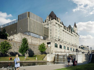 |
Proposed boxcar expansion
(artist's rendering, Larko Investments) |
Those living in Ottawa and heritage people everywhere are familiar with the proposal for an inappropriate expansion of the Chateau Laurier (the "boxcar expansion"). The initial proposal should have triggered a strong response from Parks Canada and the RCLS Committee. But Parks Canada has been weak on the issue and RCLS completely silent. The proposed expansion will have a dramatic negative impact on the visual value of the Ottawa Lockstation. A built heritage expert, Dr. Christina Cameron, noted in her intervention in the process (letter of June 8, 2019 to the City of Ottawa planning committee) "That the protection of views is an important international issue is demonstrated by decisions of the World Heritage Committee" citing the de-listing of the Elbe Valley World Heritage Site in Germany due to inappropriate development.
Fortunately the Committee of Adjustment, which reviewed the "minor" variance required for the development to be approved, refused the variance, noting that it wasn't minor and doesn't respect the landscape (the visual values). So, someone gets it (at least this committee does). This very close call is just a highly visible example of the fact that there is still no protection in place for the visual values of the Rideau Canal and the fact that Parks Canada is not engaged in vigorously protecting those values.
2020 Update. The developer, in consultation with Heritage Ottawa, has come up with a new design much more conformable to the heritage of the site. It's still not an ideal solution, as a councillor noted "it is middling, average and of ordinary design" with a rating of "good enough." For more details see: heritageottawa.org/chateau-laurier-addition
|
Rideau Corridor Landscape Strategy - Timeline
| 2007 and 2008: |
Parks Canada internally reviews issue to determine strategy for addressing the ICOMOS recommendations. |
| 2008 |
Parks Canada meets with Provincial ministries and forms a provincial working group [since abandoned]. |
| January 2009 |
First Nations of Eastern Ontario invited to participate in the process. |
| April 2009 |
An "Open Space" Forum is held. Unfortunately it is not specifically focused on the visual values and protection of the Rideau Canal. The public was invited to bring forward any issue and so every issue affecting the Rideau is brought up. No concrete conclusions. |
| May 2009 |
A Steering Committee for the Rideau Corridor Landscape Strategy (RCLS)is formed consisting of representatives from a broad spectrum: First Nations, Provincial Ministries, Municipal representatives, NCC, RVCA, CRCA, tourism, business, and environmental and heritage NGOs. It appeared to be a good blend of government and public representation. The initial job of the Steering Committee is to help draft an RFP to conduct a visual values study and to recommend the best protection mechanisms for those values. Parks Canada has a RCLS secretariat whose job is to direct and facilitate the work of the steering committee. |
| June - October 2009 |
The Steering Committee meets several times to refine what should go into the visual values study, how the Province of Ontario (which has ultimate control) can be more closely involved and how public participation can be maximized in the study. |
| June-July 2009 |
At some point in this period a municipal Mayor complains that he is not part of the process. Rather than adding him to the committee, Parks Canada starts to re-evaluate the entire process. |
| July 2009 |
Parks Canada holds a Mayor's discussion session, which, predictably, concludes that more municipal representation is required |
| September 2009 |
A Municipal Forum is held to come up with a new governance model. The model reached by consensus at this forum was to create an all-government steering committee with representatives from all 13 municipalities, plus counties, NCC, conservation authorities, the province, first nations and Parks Canada. Under this committee would be two advisory committees, a Technical Committee (municipal and provincial planners) and a Community Advisory Committee which would be representatives from community interest groups and Rideau specialists. |
| November, 2009 |
The original steering committee holds its last meeting agreeing to dissolve with the adoption of the new steering committee and its two advisory committees. The public members of the original steering committee will be part of the community advisory committee. |
| 2010 |
The all-government steering committee is formed and meets several times during the year to review issues and draft an RFP for the landscape study. The steering committee forms the Planners Advisory technical committee but holds off on forming the Community Advisory Committee. |
| April 1, 2011 |
The Steering Committee votes not to form the Community Advisory Committee. Unfortunately this was not an April Fools joke - the steering committee votes to abandon the agreed upon governance model and deny public input into the process. Parks Canada, who ultimately are responsible for the process, did nothing to stop this. |
| June 2011 |
An RFP is released for a consultant to do a visual values study and make recommendations regarding protection. This is a much watered down version of the RFP worked on by the original steering committee (the gov + public committee). For instance the question of "What are the most effective forms of protection to protect the visual values of the Rideau Canal" was not asked but "Rank identified planning and management tools according to ease and cost of implementation, and length of time for implementation" was asked (so not ranked by how effective, but how cheap). The budget for this study was less than half the originally proposed budget deemed required to do a reasonable job. |
| October 2011 |
Parks Canada reviews 8 submissions made in response to the RFP for the landscape character study. The contract was awarded on October 28, 2011 to Dillon Consulting of Ottawa. |
| March 2012 |
Parks Canada and Dillon Consulting hosts 3 public workshops which explained the study and did a superficial (pins on maps) exercise for people to indicate their favourite Rideau spots. This was simply a public "feel good" exercise, not a qualitative exercise to determine visual values. Of note, in this same month, the independent expert Dillon had originally contracted to work with them (Herb Stovel) passes away - there was no replacement.
|
| April 2012 |
After public pressure was put on Parks Canada to get the consultant out on the water to do some actual field work, a series of boat trips was decided upon. |
| June 2012 |
Four boat trips are held using Parks Canada's "Rideau Voyageur." Unfortunately these are not structured field work trips and the boat is not suited to group discussion/observations. As the error filled maps in the final report indicate, neither the consultant or Parks Canada took any notes or observations on these trips. |
| August 2012 |
Parks Canada and Dillon Consulting host five public workshops which included an interactive survey for participants using photos of the Rideau Corridor. Public turnout was poor and the survey was superficial. |
| August 2012 |
At one of the public workshops, Parks Canada and Dillon consulting confirmed that the draft report would be available for public review prior to being finalized. This, if that promise had been kept, would have been the only opportunity for detailed public review of the work. |
| January 2013 |
The draft report by Dillon is reviewed by Parks Canada and then presented to the Steering Committee. It is never made public. The Steering Committee accepts the badly flawed report at their January 11, 2013 meeting. It is interesting to note the neither Parks Canada or the municipalities and their planners apparently have the expertise to identify the many errors of fact in the report (it's either that or they never actually looked at the report in detail). |
| April 24, 2013 |
The "Rideau Corridor Landscape Character Assessment & Planning and Management Recommendations Report" is released to the public. |
| May/June 2013 |
The Landscape Character report is reviewed by public experts. One major problem that was instantly identifiable are the numerous errors on the maps. On Sand Lake for instance, almost 40% of the identified landscape character is in error (i.e. natural areas mapped as waterfront development and developed areas mapped as natural landscapes - see bottom of page for an example of the errors). The report was also measured against the Statement of Work (the RFP) and also against the ICOMOS recommendations - it falls far short in both those respects.
Bottom line is that it doesn't in any way meet the ICOMOS requirements and it is useless as a planning tool. A detailed report of these and other problems was submitted to Parks Canada in June, 2013. A whitewash reply was received in October 2013. |
Where to from here?
The Rideau Corridor remains under the same threat of inappropriate development as it did when ICOMOS made it recommendations back in 2007. Parks Canada has said that the Landscape Character Report will be an active document and used for planning. But that report is badly flawed and the maps and supporting GIS database useless for any sort of planning purpose (which begs the question of who in Parks Canada actually approved the report).
There is no evidence that municipalities bordering the Rideau Canal have any real interest in maintaining the visual character of the Rideau Canal. The Steering Committee, of which municipalities form the majority, stopped public participation in the process and watered down the RFP.
Parks Canada, which had few resources prior to the budget cuts, has almost none now with which to continue the process.
The failure of this process is one more nail in the coffin for the Rideau's status as a World Heritage Site.
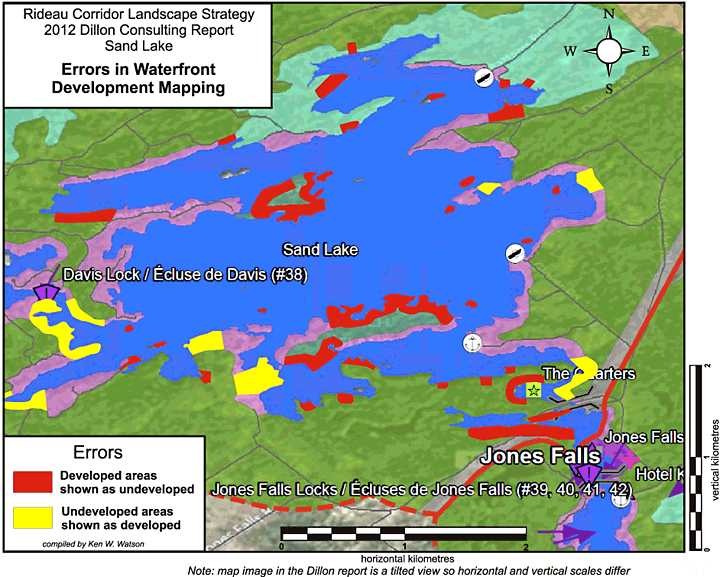
This map illustrates the type of errors present throughout all the maps in the Dillon report (the "Rideau Corridor Landscape Character Assessment & Planning and Management Recommendations Report"). In this case, the red and yellow sections on map, making up about 40% of the shoreline, are sections that are in error in the Dillon maps. This makes these maps not only useless, but dangerous to use (highly misleading) for any type of planning purpose. To date Parks Canada has not acknowledged these types of gross errors in the mapping or what they plan to do to correct the errors.

Top of Page
| |
 Site Management
 Operating Canal
 Heritage Interpretation
 Site Appearance
 Maintaining Heritage Structures
 Heritage Landscape Protection
 Public Engagement
 Public Education
 Research and Archaeology
 Documents
 Correspondence
 Management Plan
 Parks Canada
 Commemorative Integrity
 Jones Falls Photo Essay
 Solutions