Your location: Rideau Canal Home Page > Rideau Lockstations > Upper Brewers Locks 43-44
| UPPER BREWERS Locks 43-44 |
|
|
| Number of locks: 2 (in flight) |
Total Lift: 5.5m ( 18 ft.) |
Lock Through Time: 30 min.* |
| Chart No: 1513 (Sheet 4) |
GPS:1 N 44° 24.770' W 76° 18.790' |
| Chart Sales: No |
Lockstation Tel: 613-539-6847 |
| Washrooms: Yes2 |
Drinking Water: Yes3 |
Day Use Docking: Yes |
| Overnight Mooring: Yes |
Docking4 Upstream:
137m/448' |
Docking4 Downstream:
82m/270' |
| Ice: No |
Power**: Yes (U) |
Boater Camping:5 Yes |
| Boat Launch: No |
Picnic Tables: Yes |
BBQ Grills: Yes |
| Parking: Yes |
Public Telephone: No |
Self Guided Trail: No |
| Hwy Access: 0.5 km W of Hwy 15 |
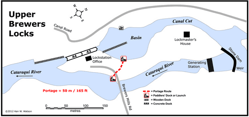
Locks Connect: Cataraqui River to Cataraqui River |
| Civic Address: 3000 Brewers Mills Road,
Kingston, Ontario |
| Special Notes: To ensure passage, boaters must arrive at least 1 hour prior to closing. The Brass Point Bridge, located 6.5 km (4 mi) upstream has a clearance of 1.2m (3.9ft). The bridge swings on demand.
|
| Of Interest: A defensible stone lockmaster's house sits on top of the knoll overlooking the lock. Used as the lockmaster’s residence, the gun slits have been sealed in, but if you look closely, you can see where they were. Behind a row of cedars on the shore of the basin is “The Ark,” an old, very large “houseboat,” pulled up on shore many decades ago, now a private residence. |
Notes: Gas is available at marinas in Cranberry Lake and near Seeley's Bay. No local services. Solitude lock. Full services (groceries, restaurants, etc.) are available in Seeley's Bay.
Parks Canada has two oTENTiks (canvas topped A-frame cabins) at this location available for rent |
|
* Time to actually go through the locks. Allow at least twice this time when trip planning. See Schedule Caveats.
** U = upstream side, D = downstream side
1) GPS data should not be used for navigation. See the GPS page.
2) Washrooms are not wheel chair accessible.
3) Unless indicated otherwise, water at the lockstation is potable.
4) Includes both blueline and greyline docking - see Lockstation Docking Page.
5) Allows tent camping for those arriving by water and also for cyclists and hikers.
|
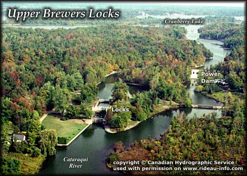 |
Upper Brewers Lockstation looking NortheastAnother of the very peaceful southern locks, Upper Brewers is a popular overnight spot for boaters. To the north the Rideau opens up into an expanse of lakes. Don't forget to catch the profile in rock of the Duke of Wellington just before you get to Cranberry Lake. It is marked on the charts.
photo copyright © Canadian Hydrographic Service - used with permission |
Comments: send me email: Ken Watson
©1996- Ken W. Watson
|