Your location: Rideau Canal Home Page > Rideau Lockstations > > Lower Brewers Lock 45
| Number of locks: 1 |
Total Lift: 4.0m ( 13 ft.) |
Lock Through Time: 15 min.* |
| Chart No: 1513 (Sheet 4) |
GPS:1 N 44° 23.350' W 76° 19.500' |
| Chart Sales: No |
Lockstation Tel: 613-876-7043 |
| Washrooms: Yes2 |
Drinking Water: Yes3 |
Day Use Docking: Yes |
| Overnight Mooring: Yes |
Docking4 Upstream: 80m/261' |
Docking4 Downstream: 130m/425' |
| Ice: No |
Power: Yes |
Boater Camping:5 Yes |
| Boat Launch: No |
Picnic Tables: Yes |
BBQ Grills: Yes |
| Parking: Yes |
Public Telephone: No |
Self Guided Trail: No |
| Hwy Access: W of Hwy 15 |
Lock Connects: Cataraqui River to Cataraqui River |
| Civic Address: 1419 Washburn Road,
Kingston, Ontario |
| Special Notes: To ensure passage, boaters must arrive at least 30 minutes prior to closing. Swing bridge with a clearance of 1.3m (4.2 ft). Bridge swings on demand. Lower docking (with power) is limited (8 spaces) due to the blue line dock.
|
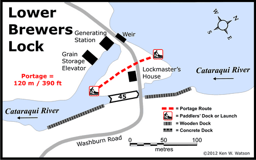
| Of Interest: One of the four remaining Unequal Arm, Center Bearing timber swing bridges on the Rideau, this beautiful swing bridge is so well balanced that one person can swing it by simply pushing on it. A sawmill existed here at the time of canal construction and a bypass channel was cut in order to leave the mill intact. Water power continued to operate mills in the 19th century and still operates a small hydro-electric station today. Doner Studio (metal art) is located in the old grain storage elevator near the lock. An apple orchard is located just down the road at the junction with Highway 15. |
| Notes: Gas is upstream at marinas in Cranberry Lake and Seeleys Bay. No local services. Solitude lock. |
|
* Time to actually go through the locks. Allow at least twice this time when trip planning. See Schedule Caveats.
1) GPS data should not be used for navigation. See the GPS page.
2) Washrooms are wheel chair accessible.
3) Unless indicated otherwise, water at the lockstation is potable.
4) Includes both blueline and greyline docking - see Lockstation Docking Page.
5) Allows tent camping for those arriving by water and also for cyclists and hikers.
|
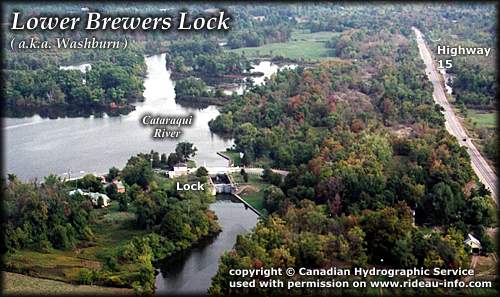 |
Lower Brewers Lock looking NortheastLower Brewers, also known as Washburn, is a peaceful lock with a wooden swing bridge. An attraction for those passing through in September and October are the lovely apples at the nearby apple orchard within easy walking distance (ask the locksmaster)
photo copyright © Canadian Hydrographic Service - used with permission |
Comments: send me email: Ken Watson
©1996- Ken W. Watson
|