Merrickville Locks 21-23
| location map | lockstation information |
The Setting
According to MacTaggart's survey, the rapids here fell "no less than 27 feet 10 inches" (8.5 m). The fall of water right at Merrickville was 14 feet (4.3 m). It was this attractive bit of hydraulic power that led Roger Stevens to this site in about 1790. He built a sawmill that was acquired by William Mirick after Stevens' death in 1793. Mirick brought his family to settle in the area in the early 1800s. He received land grants to what is today Merrickville in 1802/03 and 1810. By the time the canal was to be built, Merrickville was a thriving community. A little ways upstream of Merrickville, the River widened out and as noted in Burrows May 1827 survey, "the banks on both sides are low, and in most parts of its banks overflowed."
The Plan
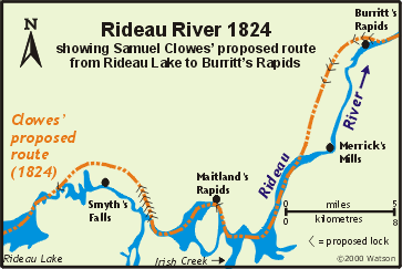 Samuel Clowes' recommendation in 1824 was to bypass the Rideau River in its entirety between the foot of Burritt's Rapids, to the still water above Merrick's Mills where a settler named MacCree (or McCreas) was located. The route would have gone through the lands to the west of the river and would have required six locks and a great deal of excavation work. Colonel By abandoned this plan in the very early stages, opting instead for his slackwater system of drowning rapids by building dams in the main channel of the Rideau. Samuel Clowes' recommendation in 1824 was to bypass the Rideau River in its entirety between the foot of Burritt's Rapids, to the still water above Merrick's Mills where a settler named MacCree (or McCreas) was located. The route would have gone through the lands to the west of the river and would have required six locks and a great deal of excavation work. Colonel By abandoned this plan in the very early stages, opting instead for his slackwater system of drowning rapids by building dams in the main channel of the Rideau.
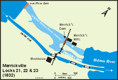
The original tender in early 1827 called for "Three Locks, of 8 feet 4 inches lift each, with considerable Rock and Earth Excavation in Merrick's Snie. The Wing Walls of the Locks and side retaining Walls will be considerable; Also, Dam at the head of Merrick's Snie, lift the Rideau River into said Snie: this Dam will be about 7 feet high and 180 feet long." This snie was the flood channel on the southeast side of the river. At the time of the canal construction in 1827, water diverted by William Mirick’s dam on the main Rideau River channel was going through this area.
On close examination, Colonel By realized that if he built his locks in the snie, it would force all the water to go through Mirick's sluiceways. By felt that spring flood would surely damage the mills, and that Mirick would likely sue for damages. In his 1830 report, By, in commenting on the changes he had made to the original plans, stated that, "it appears that the Canal might judiciously be carried to the East of the Snie, and that by placing the Locks separately, according to the nature of the Ground, with Basins between them, the increase upon the Original Estimate would not Amount to more than £4000, and this mode would also prevent any Claims for Damages to the Mill, the Original Channels of the River not being interfered with, the Dam being placed at the head of the Rapids, and considerably above the Snie in question, and as this latter mode appeared to me the judicious, and the one that would most probably be attended with the least Expense, I have according adopted it …"
This final plan created the waterfront of Merrickville as we see it today, the locks excavated in the east bank of the Rideau, a piece of land separating the locks from Merrick’s Snie, the snie (a weir now sits at the head of the snie), then the island (on which the old Industrial Complex now sits), and then the original channel of the Rideau River where the power station, with its dam, is now located.
Building the Locks
The contractor was A.C. Stevens & Co. Some reports show H.C. Stevens & Co. A.C. or H.C. Stevens remains a Rideau mystery since, even though he was a major Rideau contractor (Nicholsons and Merrickville), there has yet to be any historical information found about him (including his first name). Stevens was also the contractor for Nicholsons.
The three locks were detached so that they could follow the natural contours of the bank of the river, requiring less excavation. An overflow dam constructed of timber was placed at the head of the rapids, near the entrance to the canal cut. This dam was raised an additional 1 foot 6 inches (0.5 m), to put that much additional water depth upstream to Maitland's Rapids (now Kilmarnock), in order to lessen the amount of rock excavation there. The overflow dam allowed a natural flow of water into the mill pond above Merrick's mills, leaving them essentially undisturbed.
His Excellency Sir Peregrine Maitland laid the "first stone" at Merrick's Mills in October 1828. It was noted that the locks were already under construction, but that this could be considered the first true stone since the previous work had been done on locks of the original smaller size, which would have to be taken up and replaced with locks of the new, larger dimensions.
 No significant difficulties were encountered in the construction. Coffer dams had to be built to keep the water out of the upper and lower excavations during the construction period. All three locks had bare bedrock floors. The combined lift was 25 feet (7.6 m). No significant difficulties were encountered in the construction. Coffer dams had to be built to keep the water out of the upper and lower excavations during the construction period. All three locks had bare bedrock floors. The combined lift was 25 feet (7.6 m).
The only problem occurred in August 1831, when Colonel By wanted to officially open the lower section of the Rideau, from Ottawa to Burritts Rapids. In early August, William Mirick took it upon himself to dam the Rideau River, in order to do repairs on his mill. This dropped the water level to such an extent as to preclude navigation downstream of Merrickville. This must have irked Colonel By to no end, especially considering all the efforts he had made to avoid disturbing Mirick's operation during the building of the canal. Colonel By had obviously made great plans for this opening. The four silver cups he had made up to award to his best contractors (Phillips & White, Drummond, McKay, and Redpath), to celebrate the opening of the canal, were all dated August 21, 1831.
The problem created by Mirick's damming of the river sparked By to write to the Ordnance office in Quebec, in August 1831, "I have the honor to report that after exerting myself with the hope of opening the Rideau Canal on the 21st Instant from By Town to Burrits and having every thing ready to pass Steam Boats, I find the Navigation impeded by the supply of water being cut off by Mr. Merrick having dammed up the river, to enable him to perform repairs at his Mill etc.; I therefore respectfully beg to observe that if individuals are allowed to Control the waters of the Rideau Canal, the great expenditure that has already taken place will be rendered of little value; consequently it appears indispensably necessary that Mr. Merrick should be written to on this subject and that law Officers of the Crown should be authorized to take such steps as will effectually prevent such interruptions in future, waiting your instructions."
The blockhouse was the largest of four built along the Rideau, although quite a bit smaller than By had originally envisaged. It was essentially completed by October 1832, although renovations to the building continued until 1835. The first floor of the blockhouse was built of masonry, four feet (1.2 m) thick at the bottom, tapering to three feet (0.9 m) thick at the top. The ceiling (second floor) was also lined with masonry. The roof and upper storey were covered in tin to make them fire resistant. The blockhouse was surrounded by a ditch (dry moat). The lower masonry section stood 22 feet 6 inches (6.9 m) from the base of the ditch. The upper floor measured 11 feet 1 inch (3.4 m) to the eaves. The masonry was done by the canal contractor Stevens and the timber work by one of his carpenters, name presently unknown.
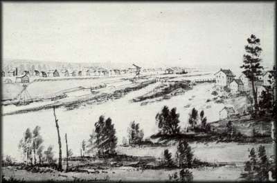 |
Merrick's Mills; ca. 1840s
John Burrows, watercolour over pencil, Archives of Ontario
Visible in this painting are the three detached locks at Merrickville, the blockhouse, Merrick’s Mills (on the right) and the growing community of Merrickville. The upper lock is crossed with a King Post Truss bridge, a second bridge crosses Merrick’s Snie and a third bridge is on top of Merrick’s Mills’ dam. A steamer is passing by a storage building where The Depot sits today. |
Through the Years
For the most part routine maintenance work was done. The upper basin required the most work, with the upper basin wall completely rebuilt in 1890-91. In 1900 the south wall was rebuilt. In 1913 the middle and lower basins underwent extensive repairs. In the period 1915-1935, the upper lock was almost completely rebuilt with concrete. The rock facing on the upper entrance cut was repaired several times.
The most significant changes came with the dam and weir. Originally a dam was located 1,300 feet (400 metres) upstream. There was a problem of leakage from the upper canal cut into the old riverbed. In 1841 the dam was washed away in the spring flood. It was replaced with another timber crib dam. In 1847 the dam was almost destroyed again, but the timely aid of several Merrickville residents helping out canal staff and working through the night saved the dam (and the downstream buildings).
In 1912, the original timber dam at the head of the cut was removed and a new dam was positioned across the river in line with the downstream end of the first lock (at the head of Merrick’s Snie). In addition to the dam, a wing dam was constructed along the north shore of the river to prevent flooding of that part of the town.
Over the years several bridges have spanned the canal works and river. The original bridge crossing the locks was a rolling bridge, positioned over the lower end of the upper lock. It was replaced in 1843 by a timber swing bridge. In 1892, the swing bridge was replaced with a new steel swing bridge, this time located just downstream of the lower gates of the upper lock. This new position allowed more vessels to pass underneath it without having to swing the bridge (and disrupt traffic). It was replaced in 1933 by another steel bridge which was electrified in 1955. The current electric swing bridge was installed in 1990.
In 1873, Lockmaster Matthew Johnston described the Blockhouse as: "Roof is in a very leaky condition. The tin thereon is loose through high winds. The building generally is minus of its original evenness, in consequence of the failing condition of oak blocks at the base, supporting its principal posts. The capacity of the roof is just now undergoing a test. There is a space of about ten inches between the roof and the leading posts, which originally supported the former. There is however yet a sort of union existing between them, effected by a miniature post, with braces, extending from the apex of the roof to a beam into which it is placed and secured, said beam having connection with the main posts. It is therefore self-evident that as the building settles the strain upon the roof is increased. The almost hourly cracking of the whole frame-work convinces the reported that the edifice is in a dangerous state."
In about 1909, the masonry of the second floor of the Blockhouse was in such a dangerous state that the whole of the second floor had to be removed. In the early 1960s the Blockhouse came close to being demolished. The Department of Transport intended to replace it with a new storehouse. However, a few voices in government in favour of historic building preservation prevailed, and from 1962 to 1965 it was restored, for the most part faithful to its original architecture. In 1967 it was leased to the Merrickville and District Historical Society to operate as a museum. In 2024, the MDHS transferred management of the blockhouse to the Village of Merrickville-Wolford. It is owned and maintained by Parks Canada.
The Depot dates to the 19th century. A storehouse has stood near the present location of the Depot since the canal was built. The present-day building was built c.1864. It was renovated by Parks Canada in 2020-21. Friends of the Rideau has operated the Depot as a Rideau Canal interpretive centre since 1995.
The wooden frame lockstation office adjacent to the centre lock was built in 1966-67.
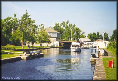 |
Merrickville Locks - looking from the middle lock to the upper lock
photo by: Ken Watson, 1999
Boats are proceeding through the turning basin to the middle of three locks at Merrickville. The largest blockhouse on the Rideau is visible on the left of the upper lock. Note that there is very little guard on this lock. The main guard is on the upper lock which protects the lower turning basins and locks. |
The Lockmasters to 2000
A carpenter, Thomas Buck was recommended by By. However, the first recorded lockmaster was William Mitchell who served at Merrickville until mid-late 1836. Mitchell transferred to another lock and was replaced by John Johnston, formerly a sergeant in the Royal Sappers and Miners. Johnston remained until his death in August 1869 at which time his son, Matthew Henry Johnston, took over. Matthew Johnston retired in 1907, and a shopkeeper in Merrickville, John Cranstoun, served as lockmaster until his death on December 7, 1917. He was followed by acting lockmaster Richard Philips in 1918, who was replaced by R. Nelson Paul who served from 1918 to 1925; followed by William Lang in 1925; unknown from 1926 to 1932; R.G. Owen from 1932 to 1943; R.G. Louis in 1944; W. Ward in 1945; R.V. Marshall in 1945; T. Elmer Bradford from 1946 to 1950; Jack Smith from 1949 to 1971; Grenville Murray from 1972 to 1984; Doug Provick from 1983 to 1989; Burt Alford as acting lockmaster in 1990 and Rob Christopher from 1991 to 2000.
Mirick or Merrick
The original settler was William Mirick. However most of the canal era surveys and reports used the spelling Merrick. The Post Office established in 1829 used Merrickville. In 1860, the village was incorporated as Mirickville, but in May 1862 the name was changed to Merrickville. The Mirick family also changed its name to Merrick at that time.
|