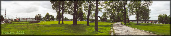
Smiths Falls Locks 28-31
| location map | Smiths Falls Combined lock info | Smiths Falls Detached lock info |
The solution for providing navigation through Smiths Falls; "seems rather a puzzler."
N.H. Baird, 1828.
The Setting
At Smyth's Falls, the river fell 36 feet (11 m) in less than a quarter mile (0.4 km). It was noted that there were a number of islands formed by snies (dry flood channels) winding around the falls. The bedrock was very hard. MacTaggart, in considering an early plan to excavate a three mile (5 km) channel around the falls stated that the, "rock ... defies the strength of gunpowder or crow-bars to remove it, and would weary the British treasury with expenses."
Originally known as Smyth's Falls, it was named after Thomas Smyth, a United Empire Loyalist who received a 400 acre land grant in the area in 1786. Smyth did nothing with the land and in 1810 he mortgaged it to a man in Boston. In 1823, Smyth built a saw mill at Smyth's Falls, but he never lived there, choosing to stay in Elizabethtown Township on the St. Lawrence River and also at Burritts Rapids. Apparently the mortgage, which Smyth thought had been paid, had not, and in 1824 his ownership of the land was contested. Smyth lost the court case and the land was sold in 1825 to Charles Jones (of Jones Falls fame) who immediately sold it at a profit to Abel Russell Ward.
It was Ward who in 1826 was the first to move into the area and actively start to build a settlement, originally known as Wardsville. When the canal was about to be constructed in 1827, an early map showed Ward's mill and four other buildings on the north shore of the river.
The Plan
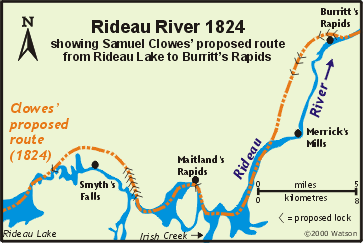 Samuel Clowes' original 1824 plan called for a canal cut to leave the Rideau River at a point just below Edmunds Rapids and follow a route north of the river, bypassing Sly's Rapids and Smith's Falls, and returning to the channel of the Rideau just above First Rapids (Poonamalie). A series of seven locks near the Edmunds end of this route would take the canal almost to the level of Rideau Lake (one more lock was planned at First Rapids to take the canal up to the level of Rideau Lake). Samuel Clowes' original 1824 plan called for a canal cut to leave the Rideau River at a point just below Edmunds Rapids and follow a route north of the river, bypassing Sly's Rapids and Smith's Falls, and returning to the channel of the Rideau just above First Rapids (Poonamalie). A series of seven locks near the Edmunds end of this route would take the canal almost to the level of Rideau Lake (one more lock was planned at First Rapids to take the canal up to the level of Rideau Lake).
MacTaggart in his 1827 survey, refuted Clowes' plan by saying, "Behind Smith's Falls, about three miles on the west side of the river, there is a large swampy tract of country, a chain of extensive beaver meadows winding-in, and terminating somewhere nigh to Merrick's Mills, fifteen miles below. These swamps, from the river levels, must form something like an inclined plane, having an elevation of nearly 100 feet. Now to cut through these swamps for fifteen miles, and miss six miles of natural river navigation, and to construct ten locks in a swamp, and all apart from each other, the whole, too, remote from reservoirs which such works require, seems to me a preposterous idea."
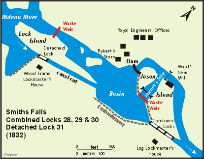
The plan proposed in 1827 was to place a dam between the west (north) bank of the river and Jason Island. The location of this dam was near a store owned by a Mr. Rykert. The dam was to be 96 feet (29 m) long at the bottom and 200 feet (61 m) long at the top, with a height of 23 feet (7 m). This dam was intended to drown the falls and deepen the still water above the falls by 2 feet 7 inches (0.8 m). In a snie (dry flood channel) that went through the island, named Hornet's snie, three locks in flight, each with a lift of 11 feet 2 inches (3.4 m) were proposed. It was noted that the dam would form an overflow weir for the locks. An embankment was required on the south side in order to keep from flooding Abel Ward's Farm. Ward's mill was in the location of the proposed dam and he was compensated £1,500 for its removal. As construction progressed, the plan had to be modified.
Building the Locks
The contract was awarded to Rykert, Simpson and Company (also known as Rykert, Simpson and Adams). Most of the work was done by George Rykert and James Simpson. They abandoned their contract in January 1831 and Bell, Richardson & Co., the contractors for Edmunds and Old Slys, took over.
The first work in 1827 was to clear and grub out Hornet's Snie and prepare the site at the west end of Jason's Island for the dam. A quarry was opened on the northwest side of the river, near Ward's mill. It was also noted that there was a good and sufficient supply of clay at Mr. Olmstead's farm near the head of the locks. By January 1828, the dam was about two thirds built and side retaining walls were also in progress.
 As the dam neared completion in 1828, problems cropped up. It was realized that if the water was raised to the planned height, it could not be contained without much more extensive retaining wall and embankment work. If taken to its planned level it would have flooded a lot of land at great expense (in compensation payments) to the government. It was also noted that the rocks were very fissured and leaked a lot of water. It was feared that putting the full head of water on these rocks would create further leaks and perhaps even cause the dam and locks to fail. In considering alternatives, the Clerk of Works, Nicol Hugh Baird, was quoted as saying that the problem "seems rather a puzzler". As the dam neared completion in 1828, problems cropped up. It was realized that if the water was raised to the planned height, it could not be contained without much more extensive retaining wall and embankment work. If taken to its planned level it would have flooded a lot of land at great expense (in compensation payments) to the government. It was also noted that the rocks were very fissured and leaked a lot of water. It was feared that putting the full head of water on these rocks would create further leaks and perhaps even cause the dam and locks to fail. In considering alternatives, the Clerk of Works, Nicol Hugh Baird, was quoted as saying that the problem "seems rather a puzzler".
In early 1829, a new plan was adopted. The three locks planned for the Hornet's Snie would be moved to the south bank of the river. The lift for each of these locks would be lowered to 8 feet, 5 inches (2.6 m), from the original 11 feet, 2 inches (3.4 m). A waste weir would be placed in the Hornet's Snie to control spring flooding and relieve pressure on the dam. A fourth, detached lock, would be placed upstream at the foot of the upper rapids. The channel between the new fourth lock and the head of the flight of three locks would be deepened to achieve navigation depth.
Building the dam and other works by contract wasn't easy. Colonel By noted that, "the Dam at the Hog's Back and that at Smith's Falls were the first commenced; at which time there was not a man in the country that had ever done any key [stone] work, and I had repeatedly to pull down their work until they understood it, but as there are now plenty of men who understand this work I hope all my other Dams will stand the test of ages."
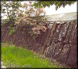 |
Top of Smiths Falls Dam
photo by: Ken Watson, 2000
Only the top few feet of the dam are exposed today. The dam, 23 feet (7 m) high, once had the important role of holding back the Rideau River. Now it serves as a barrier edge for a parking lot under the Smiths Falls water tower. |
The completed dam was not one of the Rideau's shining examples. A traveller in 1830 noted; "The Dam is of very inferior workmanship, both as to the form and qualities of the materials. The stones are far too light for such a work, and very indifferently put together. It may stand but the fact is questionable."
The locks, built later than the dam, were of better quality. Sandstone blocks, brought in from a quarry seven miles (11.5 km) away (near Merrickville), were used in construction. Flat tables of bedrock were taken advantage of to form the floors of the locks. Even so, the fissured nature of the rock led to a great deal of leakage. Attempts were made to grout the fissures. These met with limited success.
In January 1831 Rykert and Simpson abandoned their contract. This was primarily because of James Simpson who wanted to devote his full time to his milling business. Bell and Richardson, the contractors at Old Slys, took over the contract.
The completed works had three locks in flight with a combined lift of 25 feet (7.6 m). Above the locks was a basin, with 5 feet 6 inches (1.7 m) of water depth. The basin had been formed by building an embankment for 850 feet (259 m), from the top of the south side wing wall of the upper lock, to the canal cut below the detached lock. From the north side of the upper combined locks wing wall, an embankment extended 180 feet (55 m) to the stone abutment of the waste weir. The weir itself, located at the top of Hornet's Snie, was built of timber with four sluices. From the north stone abutment of the waste weir, another embankment extended 200 feet (61 m) to the 23 foot high (7 m) stone dam. This dam was six feet (1.8 m) higher than the water in the basin. The dam extended to the north shore of the Rideau River.
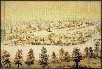 |
Smith's Falls; ca. 1845
John Burrows, watercolour over pencil, Archives of Ontario
A view of the lower flight of three locks, the basin and the upper detached lock in the canal cut to the east of the channel of the Rideau River. Several private dwelling and shops are shown on Jason Island, with a bridge leading over to Wardsville (Smiths Falls). The weir across Hornet’s Snie is visible just above these buildings, but the 23 foot (7 m) high dam, to the left of the weir, is somewhat obscured. Defensible lockmaster houses are located at both the combined and detached locks. |
The detached lock was built upon a solid rock foundation and had an 8 foot (2.4 m) lift. The height of water above the lock was maintained by a waste weir, built opposite the lock, on the north side of Lock Island. It was a low wooden structure about 4 feet (1.2 m) in height. An embankment extended from the south upper wing wall of the detached lock to the natural height of land. It was built by constructing two rough stone walls and putting clay puddle in between them to make it watertight. This was then covered by earth. The channel for the canal was excavated for about 300 yards (274 m) above and below the detached lock.
 |
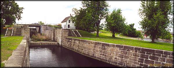
Smiths Falls Detached Lock
photo by: Ken Watson, 2000
This is a 180-degree panorama. Starting on the left is the Abbott Street swing bridge, then there are the wing walls of the lock (below the rectangular grey building), then, almost in the centre of the picture is the permanently raised railway bridge, and on the right, the weir in the original channel of the Rideau River on the north side of Lock Island. |
Through the Years
Smiths Falls has perhaps seen the greatest changes of any lockstation on the Rideau.
In the early years the major problem was maintaining water in the basin above the combined locks due to the cracks and fissures in the bedrock. Various schemes were tried including dumping wood shavings into the basin, in the hope that they would plug up the fissures. Finally, in the later part of the 1800s, the entire basin was sheeted with wood planks. As the canal management tried to seal up the basin by filling in the fissures, some local mills protested the loss of water; they were using the leaking water to run their mills. In 1909 many of the large fissures were sealed by stuffing sacks filled with cement into them. By 1921, the whole of the south side of the basin was walled in, and this finally fixed the leaks. In 1923, the timber facing on the north side of the basin was replaced with a concrete wall. In 1969 the south side wall was removed and replaced with a new wall.
The original dam on the north side of Jason Island is all but obscured today. Starting in 1946, the Smiths Falls Town Council asked the Department of Transport (who ran the canal at this time) to construct a wall in front of the main dam and fill in the area behind. They wanted to use this land for a new school. This idea was turned down, partly on the basis of the Department of Transport paying for a project that would solely benefit the municipality and take away funds for canal maintenance. Finally, in 1959 a retaining wall was built in front of the dam, and the area between this wall and dam filled in. Over the years, the channel behind the dam was also filled in. The water tower now sits just in front of the dam. The stones of the top of the dam now form a barrier wall for a parking lot.
The timber waste weir was replaced in 1859 by a new timber dam and bulkhead. In 1862, the timber cribwork was filled in with stone. In 1887, an 85 foot (26 m) long stone dam was built to the west of the bulkhead to prevent leakage. In 1909 these structures received major repairs. In 1928, the wooden weir was removed and replaced with steel framing. The dam was redone in concrete at this time. In 1957, new decking was constructed for the waste weirs.
Defensible stone lockmaster's houses were built at both the combined and detached locks in about 1841. The house at the detached lock deteriorated and was torn down in 1895-96 and was replaced by two storey brick house. This building was torn down in 1973. A framed addition was made to the stone lockhouse at the combined locks late in the 19th century. A summer kitchen was added to the building in 1907. In 1927 a second framed storey was added to the building, and the framed addition to the west of the original stone building was removed.
In 1889, a new bridge was built over the upper lock of the combined locks, in line with Beckwith Street, replacing the original bridge with passed over the centre lock. In 1923 this bridge was replaced with a "bob-tailed plate girder swing bridge." This bridge became a constant source of complaint with the town. In 1962 the Mayor complained that the bridge was too old, too narrow and too slow (to swing). By 1970 the bridge was in such poor shape that it was posted with a speed limit of 15 mph and a 5 ton weight limit.
It was the problems with this bridge that would lead to the biggest change at Smiths Falls, the creation of the new combined lift lock. As early as 1960, the Department of Transport put forward a proposal to put in a new single lock, upstream of the combined locks. A low level bridge would replace the swing bridge. In 1968 the Town Council agreed that there was no reason to retain the old locks. Once this information become public, opposition formed. The Rideau Action Association, formed from a steering committee of the Rideau Historical Society, gathered public support to preserve the existing locks. This caused the Department of Transport to postpone its plans to develop a new lock.
In 1970, an editorial in the local press summed up the issue by stating, "It is unfortunate that the Rideau Canal appears doomed to be altered in character for the sake of "efficiency" and "progress." The argument that there is a need to speed up the passing of boats through the Rideau Canal locks may appeal to some boaters, but they are in the minority. Anybody who is in a hurry should not be going up or down the Rideau."(quote taken from DeLottinville, Peter, A History of the Smiths Falls Lock Stations, 1827-1978, Manuscript Report 373, Parks Canada, 1979).
By March 1972, the Department of Transport was ready to go ahead with the plan to replace the combined locks. A total of 2.7 million dollars was allocated to the project. However, a month later the responsibility for the Rideau Canal was transferred from the Department of Transport to the Department of Indian Affairs and Northern Development (DIAND). Concern among staff and historians within DIAND put a stop to the project in order to consider alternatives that might save the original locks.
This postponement of the project was not taken kindly by the local press. The Record News wrote, "Since the Rideau Canal has been moved from the responsibility of the Department of Transport to Indian Affairs, it would seem that a handful of historians and staff within the Department now have the loudest voice and have successfully obtained the ear of the Minister who should know better. The Rideau it would now appear, had become another plaything of a few traditionalists, with costs thrown out the window and community development ignored."
A compromise of sorts was finally reached. It was decided not to destroy the original locks, but instead, to build a new lock a little ways north of the old locks. A new bridge would be built in conjunction with the new lock. The building of the new lock and bridge took place from 1973 to 1974. The lockstation building at the new high lift lock was also built at this time. The new lock, numbered 29a (since it replaced locks 28, 29 and 30), had a lift of 26 feet (7.9 m), the highest lift of any lock on the Rideau. It was electrified, the gates being opened and closed with the use of electric-hydraulic cylinders. Boaters now pass beneath a high level fixed bridge with 26 feet (7.9 m) of clearance before entering the new combined lock.
 |
Original Smiths Falls Combined Locks
photo by: Ken Watson, 2000
Looking south into the now abandoned flight of three locks at Smiths Falls. The original channel of the Rideau River as it flows around Jason Island is visible on the right. Just barely visible to the left of the Rideau River is the concrete entrance to the new, single lift, combined lock. |
The original swing bridge at the detached lock was built in 1897. It was replaced in 1958 by the current swing bridge.
In 1912-1913, a Scherzer rolling-lift railway bridge (a type of bascule bridge) was built by the Dominion Bridge Company of Lachine, Quebec for the Canadian Northern Railway, some 350 feet (107 m) upstream of the detached lock to avoid interference with navigation and reduce the need for the bridge to be lifted. The base of the bridge was 8 feet 6 inches (2.6 m) above the level of the water. The line is no longer in service, the tracks have been removed, and the bridge is now permanently raised. It was designated a National Historic Site in 1983.
Of the many historic buildings in Smiths Falls, of interest to canal travellers are the buildings that house the Rideau Canal Office of Parks Canada and the Rideau Canal Visitor Information Centre. These buildings are on the north end of Jason Island, beside the waste weir channel. The original building on this site was a mill, erected in about 1830 by Abel Russell Ward to replace his original mill that was taken down to make way for the canal works. In 1852, Ward built a new grist mill and in 1868 he also built an oatmeal mill. In 1880, Alexander Wood bought the mills, and in 1887 he rebuilt the grist mill in stone. By 1924, the complex known as Wood's Mills ceased operation. The Town of Smiths Falls acquired the complex when it was purchased by the Water Works Commission. It was sometime during this period that the granary attached to the mill either burned down, or was torn down. In 1981, Parks Canada purchased the property, then owned by Smiths Falls' resident David James. A four million dollar restoration of the complex to bring it back to its 1887 glory, including rebuilding the granary, was launched in 1989. The granary section housed the Rideau Canal Museum from 1991 until 2012 when it handed over to Parks Canada and changed to the Rideau Canal Visitor Information Centre. Parks Canada permanently closed the visitor information centre in 2024.
Parks Canada's Rideau Canal headquarters moved from Ottawa to 12 Maple Avenue N in Smiths Falls in about 1973. In 1991 they moved into their new offices at 34a Beckwith Street, a portion of the restored Wood’s Mill Complex.
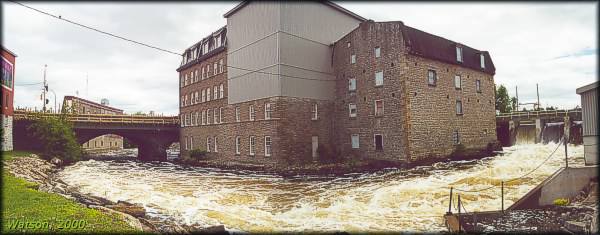 |
Wood's Mill Complex - rear of buildings
photo by: Ken Watson, 2000
Visitors viewing the front of this complex from a boat or a passing car may not appreciate its relationship to the Rideau River. The river now passes through the weir visible on the right (in the former Hornet’s Snie), maintained by the Smiths Falls' Waterworks (the main weir, upstream of this one, is maintained by Parks Canada). These building houses the Rideau Canal Office of Parks Canada and it also previously had the Rideau Canal Museum (which closed in 2012).
The rushing waters of the river are in contrast to the tranquil waters boaters experience as they gently travel through Smiths Falls. |
The Lockmasters to 2000
Combined Locks:
John White, a private in the 15th Company of Royal Sappers and Miners, was recommended by By. It is uncertain whether he actually served in this position. By about 1833 or so, Alexander Matheson, formerly of the 13th Regiment, was serving as lockmaster. Matheson died in 1866 and was succeeded by James (Josiah) Richey, a former land surveyor. Richey retired in 1871 and was replaced by his son William Richey. William retired in 1902 and was succeeded by John H. Foster of Smiths Falls who served until 1924. He was followed by R.N. Paul in 1924; Donald Grant from 1925 to 1942; Harry Langley from 1942 to 1947; Robert Moston from 1947 to 1960; Wilfred (Whip) Malloy from 1961 to 1976; Don Bennett from 1977 to 1988; G.A. (Guy) Andre from 1989 to 1997 and Ron Welch from 1998 to 2000.
Detached Lock:
By's recommendation was Alexander Kinninmouth, who served until about 1838 (going to Old Slys). Thomas Jones took over as lockmaster in about 1838, serving until 1851. He was replaced by John Jones who retired in 1871 and was replaced by his son, James G. Jones. James was retired in 1913 and replaced by his brother, then a labourer at the lock, Arthur Sidney Jones. Arthur, who had first started working at the lock in 1872, retired in 1931. It is little wonder that for a good many years, this lock was known as "Jones Lock." The various Jones were succeeded by Jack McLean from 1931 to 1947; H. Langley from 1947 to 1954; unknown from 1954 to 1958; Morrice Carty from 1958 to 1961; R.G. Dale from 1961 to 1964; unknown from 1965 to 1966; T.A. Truelove from 1967 to 1971; Don Bennett from 1972 to 1976; unknown from 1977 to 1984; John Watt in 1985; Dave Bennett acting in 1986; Guy Andre in 1987 to 1988; Peter Donnelly from 1989 to 1997; and Lawrence Agnew from 1998 to 2000.
The Contract
For those interested in the full details of a Rideau lockstation construction contract, the following is the contract signed by Rykert, Simpson & Adams in May 1827:
"We, Rykert Simpson & Adams do hereby propose to construct, erect and perform the above works according to the plans, elevations and Sections of the Same exhibited at the Royal Engineers Office at this place, and according to the Specifications of those works already exhibited and explained as follows, viz,
At Smiths' Falls on the Rideau River the following works are found necessary to be constructed - "A Dam of about 96 feet long at the bottom, 200 at top and 23 feet high about the middle of the Rapids, nearly opposite to Mr. Rykerts' Storehouse. This Dam is intended to raise the water So as to throw back 2 feet 7 in. on the Still water above, and also to lift it into "Hornets Snie" in which it is intended to place the Locks.
Three Locks of 11 feet 2 inches lift each are proposed to be built in the above named Snie to Surmount the Dam and that part of the Rapids below it.
About 420 feet in length of the East Side of the Snie will require an embankment faced with rough masonry with a puddle in the rear its whole length.
The excavations necessary for the above works to be made to the required extent as will be pointed out, and also the necessary chopping, clearing and grubbing of the land required for use of the Canal at this place.
The above works are to be constructed in the manner hereinafter described or referred to and according to the Plans, Sections and other drawings of the same which will be furnished to the Contractors by the Royal Engineer Department.
The Dam is to be constructed as follows:
- The bed of the river is to be cleared out to form a Solid foundation for the front or retaining walls of the Dam to the depth of 2 feet in the Solid Rock. This wall is to be built of large rough Stones as taken from the quarry - these are to be placed on their edges with their ends to the face of the work, they are not to be less than 3 feet long and are to be filled in with Such Stones as can be driven down between them where the angles or other parts are imperfect, So as to render the whole mass as compact as possible, or as the nature of the materials will admit; this wall is to be 18 feet thick at the base and 8 feet thick at top; the upper course is to be continued 20 feet back towards the reverse Slope of the Dam forming the top of it and Serving to cover and secure the puddle behind the retaining wall which is to be 10 feet thick, made of Clay put in the best possible manner to Secure the Dam from leaking or to render it water tight. That part of the Dam in rear of the puddle may be composed of rubble, Stones, boulders, etc etc. mixed with clay, and earth, in such proportions as shall be directed, the whole of these materials, are to be covered with at least 2 feet in thickness of good large rubble Stones laid closely together, So as to Secure the materials placed below them from being washed away. The Contractors are distinctly to understand that the said dam is to be water tight, and for the due fulfilment of this part of the agreement the recognizances will be held responsible until two Spring floods shall have passed over the dam to prove the Same after the works are finished and the Canal in operation.
The 3 Locks of 11 feet 2 inches lift each are to be constructed in the Same manner as the Locks of the Lachine Canal and as the other Locks of the Rideau Canal, the necessary plans, Sections and drawings of which will be furnished by the Royal Engineer Department, and the general Specification of the Locks as given to the Several Contractors is to be acted upon in all its particulars.
The embankment at the head of the Snie is to be faced with rough Stones about 3 feet thick as described, and as Shewn in the drawings of the same, to be well Secured by a puddle in the rear one foot thick - to be backed up with earth and the whole to be 15 feet wide at top; rear to Stand at an angle of 45º Slope according to the height. The Several excavations for the Canal to be made to the extent required as will be pointed out on the Spot, also the necessary chopping and clearing of the Lands and the grubbing Such parts as are necessary.
The foregoing works we propose to Construct erect and perform for the following prices viz:-
For the Dam four Shillings per cubic yard for the Locks ls/3d per-cubic foot of masonry.
For the embankments at the head of the Snie, Sixpence per cubic yard. - for the Dry wall 3s/ per cubic yard, 6d for the puddle & Sixpence per cubic yard for the backing of earth required in rear of the wall which is to be formed so as to be 15 feet wide at top, the Slope in rear being 45. For the excavations made to the required extent 3s/6d for the Several kinds of Rick that may occur and fourpence per cubic yard for the several sorts of earths, Clays sand etc. etc. These prices are to include all extra wheeling and other contingencies, and for the clearing Such land as may be found necessary for the Service of the Rideau Canal at this place. . Four pounds per English acre, and for such parts of it Shall be found necessary to rub out the roots £15 ,, 15 ,, 0 per acre additional making a total Sum of £19 ,, 15 ,, 0 for the parts grubbed - all the above prices in Sterling money.
The whole of the above works are to be done and executed in a masterly and workmanlike manner and to be Subject to the inspection and approbation of Lieut. Colonel By Commanding Royal Engineer Rideau Canal or to that of Such officer as he Shall appoint to inspect and superintend the Same - it being understood that only Such part or parts of the above works are from time to time to be executed as the Commanding Royal Engineer Shall think proper - and further that if in the execution of the aforesaid works, it Shall be deemed necessary to make any alteration from the original plans and Specifications, the Same is to be done at the discretion of the Commanding Royal Engineer, - the Contractors being compensated for any damage or loss they may Sustain thereby, and if any disputes or misunderstandings Should arise, the same is to be left to the decision of the Commanding Royal Engineer, which Shall be considered final and binding on all parties.
The whole of these Several works herein detailed are to be completed by the first day of June 1829, and for the due fulfilment of these agreements, we offer as Security to the amount of Two thousand pounds Sterling."
Dated Nepean, Rideau Canal, 16th May, 1827.
- taken from Parks Canada, Manuscript Report 193 by Karen Price, 1976, pp.211-213. Originally referenced as: Public Archives of Canada, RG8, Vol. 435, pp. 168-174.
|