Water Water Everywhere
by
Ken W. Watson
Note: This article first appeared in the Fall 2011 edition of Rideau Reflections, the newsletter of the Friends of the Rideau (www.rideaufriends.com).
| |
 |
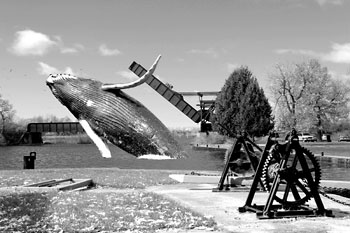
Humpback Whale at Smiths Fall Detached Lock The rare sight of a humpback whale breaching in the basin just above the Smiths Falls Detached Lock. This large animal has a gentle nature and is always respectful to Rideau boaters.
Whale photo - NOAA, Smiths Fall Detached photo - Ken Watson
|
Three apparently unrelated events on the Rideau have a common link. In 1883, the bones of a humpback whale were found in a gravel pit just north of Smiths Falls. In 1816, Lt. Joshua Jebb paddled a canoe from the foot of Jones Falls Rapids to Upper Brewers Rapids. And today, near the top of Rock Dunder (near Morton), you can find lake bottom sediments. The common link? These all represent flooding of portions of the Rideau waterway.
Let’s look at Rock Dunder. What are lake sediments doing near the top of that hill? It starts about 14,000 years ago when Rock Dunder and the rest of the Rideau countryside were about 175 m (575 ft) lower than today’s elevations – depressed by the massive weight of over a kilometre thickness of ice which formed during most recent period of continental glaciation.
By 14,000 years ago, global warming had taken hold and that ice was retreating. Meltwater was filling depressions, including that of present day Lake Ontario. However, there was no exit for the lake, ice was blocking the St. Lawrence River valley. This led to a very large lake being formed, known today as Lake Iroquois. Evidence for this lake includes the sediment deposits it left behind, such as those near the top of Rock Dunder. The surficial geology maps for this region show the remnants of these deposits, on the Rideau, scattered from the shores of present day Lake Ontario north to Perth and Smiths Falls.
About 13,350 years ago a channel opened up in the ice dam (near Rome, NY), rapidly draining much of the lake. At the same time, with the weight of the ice removed, the land was starting to rise (isostatic rebound). The water eventually retreated to become today’s Lake Ontario.
In 1883, gravel to be used as railway ballast was being excavated from the Welsh gravel pit, about 5 km north of Smiths Falls. Workers in the pit came across several large bones. Word of these bones came to the attention of J.W. Dawson of McGill University, a geologist who specialized in this sort of thing. He collected the bones and they were later identified as being pieces of a vertebrae and a rib of a humpback whale (Megaptera novaeangliae). Later investigators found bones of beluga whales (such as those in a gravel pit at the northern edge of the Ottawa airport), marine clams and other evidence of a moderate saltwater environment that existed in this area at the end of the last ice age.
This saltwater environment was the Champlain Sea, formed about 13,000 years ago as the glaciers continued their retreat over the depressed landscape. Waters from the Atlantic Ocean mixed with glacial melt-waters and river drainage to create a brackish sea which extended past (west and south) of Ottawa. The southern limit of this sea on the Rideau Canal was near Nobles Bay of Big Rideau Lake. And, at that time, beluga whales, and at least one humpback whale, were swimming over what is the Rideau River today. That same sea is also responsible for the deposition of the famous (or infamous) Leda clay – the unstable “quick clay” that underlies large areas near Ottawa (and some other parts of eastern Ontario).
The last major flooding event on the Rideau was man-made. We all know that the Rideau Canal is a slackwater canal system a navigable depth of water created by flooding. Lt. Colonel John By made an engineering decision to flood rapids rather than excavating canal cuts around them, as was the canal-building norm of the day. But he wasn’t the first person to create slackwater navigation on the Rideau – that honour goes to Lemuel Haskins who did it unintentionally back in the early 1800s.
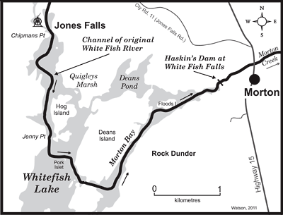
 Haskins was a miller who came to this area looking for a source of water power for a saw mill. He found such a spot at White Fish Falls - the location of today’s Morton Dam. It was here that the water of the White Fish River, with its head in Sand Lake, flowed over a set of rapids or falls, on its way to Lower Beverley Lake and from there to Gananoque. And so it was at White Fish Falls, sometime between 1803 and 1805, that Haskins built a dam and sawmill. A miller in those days needed a couple of things – a head of water to be able to turn his water wheel and a large volume of water to maintain that head. Haskins was a miller who came to this area looking for a source of water power for a saw mill. He found such a spot at White Fish Falls - the location of today’s Morton Dam. It was here that the water of the White Fish River, with its head in Sand Lake, flowed over a set of rapids or falls, on its way to Lower Beverley Lake and from there to Gananoque. And so it was at White Fish Falls, sometime between 1803 and 1805, that Haskins built a dam and sawmill. A miller in those days needed a couple of things – a head of water to be able to turn his water wheel and a large volume of water to maintain that head.
Haskins built his dam and watched as the water level in Morton Bay rose, forming a nice mill pond for his sawmill. But, no matter how much it rained, the water wouldn’t rise higher than about 2.1 m (7 ft) against his dam. Haskins had a leak.
It turned out that the leak was in the area of today’s Whitefish Lake, then an ash tree forest. Haskins’ dam-impounded water was heading south over the Cranberry Flood Plain, through the forest and marshes, eventually meeting up with the Cataraqui River at the Round Tail (just north of Upper Brewers). The Cataraqui at that time had its headwaters in Loughborough and Dog lakes. So, at some point prior to 1816, he built a second dam, this one at the Round Tail, a rocky constriction ideal for dam construction.
With the construction of the Round Tail dam, Haskins now had an extremely large millpond, stretching over 18 kilometres, from the area of Dog Lake in the south all the way up to Jones Falls in the north.
When Lt. Joshua Jebb did his survey of the Rideau in 1816, he noted both dams and the fact that they provided navigation over an area that was previously unnavigable. To directly quote Jebb’s July 14, 1816 report:
“The dam at this mill [Haskins' White Fish Falls dam] secures the communication with Cranberry Lake by overflowing what would otherwise be an extensive swamp to the depth of 7 or 8 feet and water is furnished by an ample stream which comes from the Chain of Lakes [Sand, Opinicon, Clear, Newboro] forming the other communication I alluded to [navigation route via the Rideau lakes] and may be properly considered the main branch of the Gananoqui river.
The Cranberry Marsh is rendered passable by a dam at the entrance or head [Round Tail] of Kingston mill stream [Cataraqui River] which throws the water coming from the Loughbro Lake on to it, and overflowing it to the depth of 6 feet."
When Samuel Clowes surveyed the Rideau route in 1823/24 he advocated the traditional method of canal building, excavating canal cuts around rapids. But even he saw the great cost advantage of a slackwater system, since he had a working example of it with the mill dams at Morton and the Round Tail. In his 1823 survey report he wrote:
“The whole expense [of doing a canal cut from Upper Brewers to Jones Falls] is therefore estimated in the aggregate for the nine miles and a half at £25,650. ... The expense of forming waste weirs at the Round tail and Whitefish falls, clearing the timber from the direct line of the canal on the flats, would amount to £725 — and as the difference between the two plans amounts to £24,925, the advantage of inundating the tract instead of cutting through it, obtains a decided superiority.”
Colonel By clearly saw the superiority of navigation by inundation – it appears that when he arrived in Canada in 1826, he was already forming plans to build the entire Rideau as a slackwater system. He had Jebb’s and Clowes’ reports in hand and Samuel Clowes accompanied him on his first trip along the Rideau – which would have included paddling over land created navigable by flooding.
And so, in 1831 the final flooding event on the Rideau occurred as the dams at each lockstation were completed, drowning rapids, turning rivers into lakes and forming the landscape we see today.
- Ken Watson
|