|
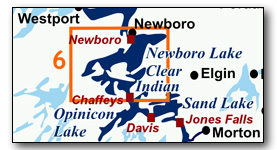
Includes Newboro, Clear, Indian, Benson, Mosquito and Loon lakes
A very scenic section of the Rideau with dozens of back bays and many kilometres of shoreline to explore. These lakes have many islands and winding shoreline and so can be paddled even when the wind is up. The map included in this guide can be enlarged (while viewing the PDF) to any level of detail you desire.
No specific route descriptions have been given for paddling the lakes - you should explore these on your own. The detailed map in this guide will allow for travel planning. However, for those just paddling through the lakes (going lock to lock), a scenic route has been suggested.
You can view or download the PDF file:
| (Clicking this link will open the PDF. You can also just right mouse click the above link and use "Save Target As" to send the PDF directly to your computer.) |
You can also view a short photo tour video of this area:

Water Access
Indian Lake: This lake is easily accessed from Chaffeys Lock, you can launch from either the dock at the lockstation, or from the public ramp down Iron Bridge Lane (44° 34.940'N - 76° 19.050'W - small paved ramp). You can also launch from Indian Lake Marina for a fee.
Newboro Lake: This lake is easily accessed from Newboro at either the Newboro boat launch (44° 38.835'N - 76° 19.200'W - paved ramp) or from a small beach just south of the launch. A small fee applies for using the parking lot and a fee also applies for using the launch.
Loon Lake: A small gravel public launch is located just north of the bridge at Bedford Mills on County Road 10 (44° 36.465'N - 76° 24.060'W).
Facilities
Lodging: If you're paddling and camping, the lockstations are a good choice for camp spots (a camping fee applies). There are also several campgrounds, a host of B&Bs and several hotels such as the Hotel Kenney at Jones Falls, the Opinicon Resort Hotel at Chaffeys Lock and the Poplars and Stirling Lodge in Newboro. For information about local accommodations see: www.rideaulakes.ca, www.villageofwestport.ca and www.rideau-info.com (this website).
Supplies: A local source for supplies is the village of Elgin (off Hwy. 15 opposite Davis Lock Road), which has a grocery store, pharmacy and hardware store. Some limited supplies can be obtained from local marinas and at Kilborn's in Newboro. Full groceries can be obtained in Westport.
Big Boats
You'll be sharing the Rideau with big power boats (cruisers). The Rideau is generally not a crowded waterway and often you'll find the large boats in "packs" - travelling from lock to lock - once they pass by you won't see any for awhile. Some of these boats can generate a large wave. The general rule for a paddler and large waves is to meet them head on, this can actually be fun in a kayak (not as much fun in a canoe).
The main navigation channel is shown on the map as a blue dashed line - this is where the big boats will be travelling. So, if you wish to avoid these, pick a route away from the navigation channel. Many paddlers prefer paddling near shore, it's more interesting (i.e. wildlife, cottages) and it keeps you farther away from the waves produced by big boats.
There are several "no wake" zones on the Rideau - these have been marked on the maps. Boaters within these areas are supposed to be travelling at a slow enough speed (less than 10 kph) that their boat doesn't generate any potentially damaging or dangerous waves.
Wind
A question often asked is which way does the wind blow? The prevailing wind, powered by the jet stream, is from the southwest. That's about the only rule of thumb. If a front is moving in then the wind can come from any direction. I've been on several paddles where I've been paddling into the wind on the way out in the morning and into the wind on the way back in the afternoon because the wind swung around 180 degrees (for some reason it never seems to work the other way around - at your back both ways). So, if you're going to travel the entire Rideau, going from Kingston to Ottawa improves the odds of having the wind at your back - but be prepared for anything.
Etiquette
Your trip planning should include a "leave no trace" approach - carry out what you carry in. Many areas are un-serviced (no garbage cans) - so plan to be self-contained. The lockstations provide waste disposal facilities.
Preparation & Safety
Please read the trip planning information on www.rideau-info.com/canal/paddling/. While these lakes are easy paddling, normal paddling preparations should be made (all required safety gear, maps, food, water, first-aid kit, etc.). Zebra mussels are present in many areas along the Rideau, so a pair of water shoes (to avoid cut feet) is recommended.
Please take all normal safety precautions, including checking the weather forecast before you head out and making sure that someone on shore knows your planned travel route and itinerary.
Navigation
While the Rideau is generally easy to navigate, taking along a set of maps is a must (in addition to any GPS you might have). Although the map in this guide is an accurate 1:50,000 representation of the waterway (when printed to 8.5" x 11"), you may also wish to also have the 1:20,000 hydrographic chart for this section (Chart 1513). For power boat navigation, the charts are an absolute must (the map in this guide should not be used for power boat navigation). The charts are also very handy for the paddler, since they show the Rideau in great detail, including depths (which can be helpful when looking for wildlife habitat or just interesting places to paddle).
The charts also show all the navigation buoys. These are all numbered (red buoys have even numbers, green buoys have odd numbers) and so can be used as an aid in locating yourself on the map when you're on open water. A subset of those buoy numbers have been included on the paddling guide maps.
For those wishing to go off the beaten path or want to know more of the topography and geographic features of the surrounding countryside, the 1:50,000 NTS map for this section is 31C/9.
Distances:
Circumference distances are approximate, following the main shorelines. The navigation channel and the scenic route are shown on the map.
- Indian Lake circumference = 12 km (7.5 mi)
- Benson Lake circumference = 10 k (6.2 mi)
- Mosquito Lake circumference = 12 k (7.5 mi)
- Newboro Lake circumference = 43 k (27 mi)
- Loon Lake circumference = 13 k (8.1 mi)
- Chaffeys to Newboro along the navigation channel = 7.9 km (4.9 mi)
- Chaffeys to Newboro taking the scenic route = 12 k (7.5 mi)
The Lakes
General Notes
The following applies to all the lakes. They are all mesotrophic lakes (moderately enriched with nutrients). Zebra mussels are present. Aquatic vegetation growth is present in most sheltered areas with a depth of less than 3 m (10 ft). Wildlife is abundant, particularly loons, herons, ospreys, turtles, frogs, muskrats and beaver. The main game fish in the water is large mouth bass (small mouth bass, northern pike and crappie are also present).
Indian Lake
In the pre-canal era, the lake was about 8 feet (1.2 m) lower than it is today. Its source water was from Newboro Lake by way of Mosquito Creek, there was no water connection at that time to Clear Lake. The completion of the lock and weir at Chaffeys in the fall of 1831 raised the water in the lake to the level it is today.
The lake has a maximum depth of 92 ft (28 m) and averages about 40 ft (12 m). The land bordering the lake is all privately owned. Most of the lake has moderate density cottage and summer home development along its shoreline. There are a few areas that remain in their natural state (mostly along Scott Island shorelines).
Clear Lake
In the pre-canal era, this lake was about 6.5 ft (2 m) lower than it is today. A narrow channel connected it to Newboro Lake. The completion of the lock and weir at Chaffeys in the fall of 1831 raised the water in the lake to the level it is today. The name Clear Lake was given to it since the lake is clear of islands, unlike the other lakes in the region.
The lake has a maximum depth of 113 ft (34.5 m) and averages about 50 ft (15 m). The land bordering the lake is all privately owned. Most of the lake has moderate density cottage and summer home development along its shoreline. There are a few areas that remain in their natural state, mostly along Scott Island shorelines.
Benson Lake
In the pre-canal era, this lake was about 6 ft (2 m) lower than it is today and about half its present size. The outflow was to Indian Lake through Benson Creek. The completion of the lock and weir at Chaffeys in the fall of 1831 raised the water in the lake to the level it is today.
The lake has a maximum depth of 45 ft (14 m) and averages about 13 ft (4 m). The back bays are mostly a shallow water environment, with extensive aquatic vegetation.
The land bordering the lake is all privately owned. About one-third of the lake has moderate density cottage and summer home development along its shoreline. There are a several areas that remain in their natural state.
Mosquito Lake
In the pre-canal era, this was a creek, flowing out of Newboro Lake and into Indian Lake. A tributary to the creek was Mississagua Creek. The water was about 6 ft (2 m) lower than it is today. The completion of the lock and weir at Chaffeys in the fall of 1831 raised the water in the lake to the level it is today.
The lake has a maximum depth of 6 ft (1.8 m) and averages about 5 ft (1.5 m). The back bays are mostly a shallow water environment, with extensive aquatic vegetation.
The land bordering the lake is all privately owned. About one-quarter of the lake has moderate density cottage and summer home development along its shoreline. The rest of the lake remains in its natural state.
Loon Lake
In the pre-canal era, this lake was about 5 ft (1.5 m) lower than it is today. The inflow to the lake was a creek originating at Buttermilk Falls, the outflow from Devil Lake. The lake drained through Stevens Creek to Newboro Lake. The completion of the lock and weir at Chaffeys in the fall of 1831 raised the water in the lake to the level it is today.
The lake has a maximum depth of 30 ft (9 m) and averages about 25 ft (7.5 m).
The land bordering the lake is all privately owned. About half the lake has moderate density cottage and summer home development along its shoreline. There are several areas that remain in their natural state.
Newboro Lake
In the pre-canal era, this lake was about 6 ft (2 m) lower than it is today. The completion of the lock and weir at Chaffeys in the fall of 1831 raised the water in the lake to the level it is today. Up until the late 1800s it was known as Mud Lake, so named for the depth of mud on the bottom of the lake.
The lake has a maximum depth of 85 ft (26 m) and averages about 20 ft (6 m). Many of back bays, particularly at the east end, are shallow water environment, with extensive aquatic vegetation.
The land bordering the lake is mostly privately owned (the exceptions being federal land in the vicinity Newboro Lock). About half the lake has moderate density cottage and summer home development, the rest remains in its natural state.
The Locks
Most Rideau lockstations offer facilities such as washrooms, water, recycling cans, waste cans and picnic tables. Most also allow camping for paddlers travelling the Rideau for a modest camping fee. Paddlers can portage the locks for free, but you owe it to yourself to lock through at least one lock in order to get the full experience of paddling the Rideau Canal. See www.rideau-info.com/canal/fees.html for the current fee schedule.
Points of Interest (listed south to north)
Chaffeys Lock: The lockstation has a single lock (lift of 3.3 m / 11.0 ft) and a swing bridge. The lock is located in the middle of what used to be the Chaffey's Rapids which drained Indian Lake into Opinicon Lake. A long (1,370m / 1,500 yd) portage used to lead around these rapids. In 1820, brothers Samuel and Benjamin Chaffey erected a sawmill here. In 1822 Samuel started building other mills and by 1826 had a sawmill, grist mill, carding mill and distillery in operation. He died in 1827 and sometime after that Colonel By tried to buy out the milling operation in order to build the lock and weir.
However, an ownership dispute between Samuel's widow Mary Ann and his brother Benjamin prevented settlement, and it wasn't until October 1829 that Mary Ann and Benjamin resolved their dispute allowing the mills and land to be purchased for £2,000 (equivalent to several million dollars today). The mills were removed in 1830 to make way for the lock construction.
The defensible lockmaster's house, built in 1844 with the second storey added in 1894, has been converted into a museum, the Lockmaster's House Museum. It is operated by the Chaffeys Lock and Area Historical Society and houses interesting photos and exhibits. It is well worth a visit.
You'll also see the old Chaffey's Mill (built by John Chaffey in 1872) which used the flow of water from the canal weir to power its operation. It is privately owned and currently being restored and converted into a B&B.
Chaffeys Locks: This is the small community at this location. It was established in the early 1870s when John Chaffey (a nephew of the original miller, Samuel Chaffey) came here and built a mill (the old Chaffey's Mill that you can see today). It's known as Chaffeys Locks since two locks were originally proposed for this location, but in the end, only one was built. In "town" you will find the entrance to the Chaffey's Lock Cemetery and Memory Wall , located beside the Brown's Marina store. This cemetery was used for those who died during the construction of the canal at this location and also for local residents (to the late 1800s). You can also get to the cemetery (or return from the cemetery) by taking the Marion Dunn Heritage Trail, the entrance to which can be found near the Community Hall. The community is also home to the lovely old Opinicon Hotel which started out in about 1899 when Lockmaster William Fleming acquired the property and built a tourist lodge. In 1902, William Laishley bought the property, added a wing to the building and called it Idylwild. He and his wife Etta operated it as a tourist resort until 1904 when he sold it a fishing club from Youngstown, Ohio, who operated it as a private club known as the “Opinacon Club”. In 1921 it was purchased by Mae and William Phillips of Pittsburgh who turned it back into a public tourist resort.
A walking tour brochure of Chaffeys Locks is available in the hamlet and on-line.
Iron Bridge/Cataraqui Trail: Just to the north of the locks you'll paddle under the old Iron Bridge (9.1 m / 29.5 ft above the water), built in 1912 by the Canadian Northern Railway as part of their Montreal to Ottawa to Toronto line. The tracks were lifted in the early 1990s and, in 2000, it became a crossing for the Cataraqui Trail, part of the Trans-Canada Trail system. The old Chaffey's railway station is located just a few hundred metres southwest of the bridge. Chaffeys Locks is at km 42 of the 102 km long trail which stretches from Smiths Falls (km 0) to the east to Strathcona (km 102) to the west.
Indian Lake: There are some very nice old cottages along the southeast shoreline of the lake.
Richardson (Fettercairn) Island: This island has a fascinating history. It was originally known as Fettercairn Island, a name meaning "rock surrounded by water" given to the island by the Richardson family who purchased it in 1901. The Richardsons also acquired property on Scott Island.
During WWI, Agnes Richardson (later Agnes Etherington) had a 45-bed hospital built on the island, to be used for convalescing shell-shocked soldiers. It opened in May 1916. A large boathouse was added in 1917. The Richardsons also owned 139 acres on Scott Island and, in the fall of 1916, 45 acres of that property was devoted to additional housing for the men. When WWI ended the facility was no longer needed and it closed down.
Shortly afterwards, the Richardsons gave the island and part of the Scott Island property to the Girl Guides of Canada for use as a training centre. The island at that time became known as Girl Guide Island. The Richardsons retained the name "Fettercairn" for their own Scott Island property and built a pergola and dry stone walls near the shore (these can be seen today). The Girl Guides used the island as a training centre, known as the Dominion Training Centre, starting in the 1920s and continuing until sometime in the 1930s. The only indications today of the hospital are its foundations and part of the stone chimney. The island became known as Richardson Island, although locals still refer to the little island beside the main island as Girl Guide Island.
Benson, Mosquito and Loon Lakes: for those taking a scenic tour of this area, see the section after Newboro in this list.
Little Isthmus Channel: Prior to the canal being built, Indian Lake and Clear Lake were separated by a narrow neck of land, the Little Isthmus (today called "The Isthmus"). A 35 m (40 yd) portage was required to cross between the lakes. A channel was excavated through the isthmus during the construction of the Rideau Canal and widened in the mid-1800s. A manual ferry has been in use in this location for almost 100 years.
Clear Lake: The name of this lake derives from the fact that it is "clear of islands". There are a few islands today, mostly a result of flooding caused by the lock and weir at Chaffeys, but the main part of the lake still remains clear of islands. The cliff on the south shore, just to the west of Little Isthmus Channel, is a popular diving spot for the brave.
Elbow Channel: The connection between Clear Lake and Newboro Lake is a natural one. Early (1830s) steamboat captains coined the name "the Devil's Elbow" for the narrow channel and tricky turn which took some skill to do with a paddle wheel boat.
Newboro Lake: Newboro Lake has a long history of cottaging and you'll notice many lovely old cottages on the lake, both on-shore and on the islands. The original name for the lake (through to the late 1800s) was Mud Lake, named for the depth of mud on the bottom of the lake.
Iron Island: This is the site of the earliest mining, outside of the quarries for the stones to build the locks and dams, on the Rideau Canal. The Chaffey brothers; John, Benjamin and Elswood appear to have acquired the mining rights to this deposit in about 1850. It was reported that they shipped 340 tons of iron ore that year to Kingston. The deposit was investigated by Alexander Murray of the Geological Survey of Canada and samples of this magnetic ore were shown at the first World’s Fair in London, England in 1851. The Chaffey Mine, as it became known, consisted of four small open pits that were used to extract the ore (magnetite). Sir William Logan of the Geological Survey reported that the Chaffey brothers had mined 2,000 tons of iron ore from this deposit in 1858 and 4,000 tons in 1859 and shipped it, via the Rideau Canal and Lake Ontario, to Pittsburgh.
A causeway (still existing, just a bit underwater) linked the island with the mainland, with a gap between it and the island so that a barge could be slipped in. A boarding house stood at the mainland end of the causeway.
In about 1860, a second iron mine, the Matthews Mine (also known as the Yankee Mine), was opened on the mainland by Frank and Eugene Fifield. It was located about 350 m inland from the north shore of Iron Mine Bay. It consisted of a single open pit 300 feet long by 100 feet wide by 40 feet deep.
There are no definitive figures on the total amount mined from these two mines. In 1871 it was reported that a crew of 12 men had mined 3,500 tons from the Chaffey mine that year. That same year, at the Matthews Mine, a crew of 15 men mined 4,000 tons. This ore at this time was being shipped to Cleveland, Ohio. The mineralization was low grade (52% iron) and was only economic due to its location on the Rideau Canal, which allowed for direct on-water shipping to market. By 1885 both mines had closed.
Excitement was sparked in Newboro in the late 1950s with the arrival of exploration crews from New Mylamaque Explorations Ltd. Diamond drilling was carried out which delineated a potential open pit deposit containing 50 million tons grading 26.7% iron and 6% titanium dioxide. The two old mines, which sit about 800 metres from each other, are part of this single deposit which is about 100 m wide and 1000 m long. The deposit was (and remains) uneconomic. Today the mining of this deposit (or any deposit on the Rideau Canal) would never be allowed due to provincial mining regulations.
If you have a magnet or a magnetic compass handy when you visit the island, see if you can identify the magnetite rich rock. People exploring for iron in the 19th century used a dip needle (basically a compass placed on its side) to locate magnetite deposits.
Newboro Lock: The lockstation here has a single lock (lift of 2.6 m / 8.7 ft). It is located on "The Isthmus," the watershed divide between the Rideau River watershed to the north and the Gananoque/Cataraqui watershed to the south. In the pre-canal era, a 2,400 m (2,600 yd) portage connected Rideau Lake with Newboro Lake. The original intention for the canal was to simply excavate an open cut between the two lakes. But the water couldn't be sufficiently raised at Chaffeys so Colonel By decided to put in a lock here at Newboro. In the end, with many difficulties, a lock and an excavated channel leading to Upper Rideau Lake were completed. At the lockstation you'll find a blockhouse, built in 1832, one of only four built along the Rideau. The lock was converted to electrical operation in 1966.
An interesting feature of this lock and also of Narrows Lock is that both were built without breastworks (an upper foundation). Colonel By didn't intend for these locks to be permanent, he thought that when conditions and technology permitted, his original plan, of simply having the isthmus at Newboro crossed by an open cut, with no locks here or at Narrows, could be implemented.
Newboro: Newboro features some excellent shopping opportunities for those who wish to exercise their credit cards.
This community had its roots with the building of the Rideau Canal. Originally it was just the portage route across the isthmus separating Rideau Lake from Mud (Newboro) Lake with no permanent settlement. A fair sized community grew during the building of the canal, but this was abandoned once the canal opened. It wasn't until about 1836 that Benjamin Tett built the first permanent home that was to form the nucleus of a new community, known as New Borough. He also became the first postmaster for the village, whose name was later shortened to Newboro'. It was officially incorporated as a village in 1876.
The village features lots of interesting history and a heritage walking tour brochure of Newboro is usually available in the village (and also on-line).
Old Presbyterian Cemetery: For those willing to take a little hike, this cemetery, first used as a burial ground for workers who died during the construction of the canal at Newboro, is located on the north side of County Road 42, 300 m (1,000 ft) to the west of the bridge over the canal. If you're at the lock, a shortcut is to walk up the road on the south side of the lock (Fire Rd H1) to County Road 42. You'll find the cemetery about 140 m (450 ft) west of that point. The area around Fire Rd H1, near County Road 42, was the site of the main construction camp (1829-1831) for the building of the Newboro Lock.
On the south side of the road, in front of St. Mary's Cemetery, is a plaque commemorating the Royal Sappers and Miners (who worked to help build the Newboro lock and cut). About 10 of them died in this area during construction and were buried in the Old Presbyterian Cemetery. That cemetery saw continued use as a burial ground until the 1940s.
The signboard in front of the Old Presbyterian Cemetery is misleading when it says that the men were buried in unmarked graves. During canal construction, funerals were held for workers who died on site and their graves were marked with wooden markers, but these have long since rotted away.
-------------
Benson and Mosquito Lakes: Benson was a small lake in the pre-canal era and Mosquito Lake didn't exist, it was a creek that drained the west end of Newboro Lake into Indian Lake. The flooding of the area from the lock and weir at Chaffeys created Mosquito Lake and flooded the low land around Benson Lake. So today, there are many areas of shallow water, home to marshland wildlife.
One of the original indigenous paddling routes went by way of Mosquito Creek since it avoided the portage between Clear Lake and Indian Lake (both routes were used).
Loon Lake: Keep an eye out for ospreys which have nests around this small lake.
Bedford Mills: This is a spot with a long history of both milling and shipbuilding. The outflow from Devil Lake dropped over Buttermilk Falls and then continued to Loon Lake. It was these falls that attracted two fellows, Barnet and Legg, to set up a sawmill here by 1829. They were squatting on the site and in 1831, Benjamin Tett acquired the milling rights and continued to operate the sawmill. A sawmill operated in this location until 1920. You'll notice docks made of slab wood - these were used to pile the lumber sawn by the mill, ready to be loaded onto barges. The beautiful stone grist mill, now a private residence, was built in 1850 and operated until 1904. This was also the site of shipbuilding - at least 29 vessels, mostly barges, were built here between 1855 and 1921.
In the 1880s, a proposal was put forward to build a canal link between Devil Lake and the Rideau Canal. Plans for a set of locks, to be located here at Bedford Mills, were drawn up, but that's as far as it went.
Route Suggestions
Chaffeys Lock to Newboro Lock Scenic Route
Follow the main navigation leaving Chaffeys Lock, but then head west, along the south shore of Indian Lake. When due south of Richardson Island, turn north and paddle to the island. This was Fettercairn Island where you can see the remains of the old hospital. Continue to the north shore of the lake and turn east and paddle along shore to the narrow cut between Indian and Clear Lakes. Going through the cut you'll notice one of the shortest ferry crossings in Canada. Turn west and follow the south shore, paddling past a favourite rock cliff diving spot. Then turn north and paddle to the narrows between Clear and Newboro lakes. Once in Newboro Lake, paddle past the west side of Goat Island and continue north to the Green Islands. Turn west and paddle along the shore until you are south of Channel Island. Turn north and paddle across the lake to Iron Island. Note the old (1850s) open pits on the island, used to extract iron. Note the causeway, now a few inches underwater, that linked the island with the mainland. Now turn east and paddle to Newboro.
To Bedford Mills
Two interesting paddling routes can be taken to get to Bedford Mills, from either Chaffeys or Newboro.
From Chaffeys, paddle to Richardson Island. From there, turn west and paddle to Mosquito Lake. Paddle through that lake into Pollywog Lake and then through the channel into Newboro Lake. Cross Newboro Lake to Stevens Creek, turn west and head into Loon Lake. Paddle straight through Loon Lake to the County Road 10 bridge. Paddle under the bridge into the pond below the mills. Please note that the old mill is now a private residence. The one way distance is 12.5 km (7.8 mi).
From Newboro, paddle south along the shoreline to Iron Island. Note the old (1850s) open pits on the iron, used to extract iron. Continue paddling west to Stevens Creek and follow the directions shown above. The one way distance is 9.5 km (5.9 mi).
Geology
As you paddle the Rideau Canal, the route you follow is defined by its geology. Geological highlights have been included in the Points of Interest listings and a general geological history of the route can be found on the Geology of the Rideau Page.
Wildlife Viewing
A section about wildlife viewing, what you might expect to see on your Rideau journey, has been included in text form in the PDF. A version of this information, that includes photos of some typical Rideau wildlife, can be found on the Fauna of the Rideau Page (in the ecology section of this website).
Errors
If you find any errors or omissions in this guide, please let me know (rideauken@gmail.com) and I'll get them fixed.
Terms of use
This guide may be freely used for personal purposes. Have fun on your Rideau paddling adventure.
Commercial use is not allowed in whole or in part without express written permission.
©2010- Ken W. Watson, All Rights Reserved.
You can view or download the PDF file:
| (Clicking this link will open the PDF. You can also just right mouse click the above link and use "Save Target As" to send the PDF directly to your computer.) |
|