|
Upper Rideau Lake
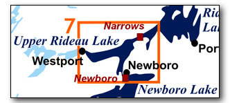
This is a guide to Upper Rideau Lake, with Newboro Lock at the south end, Narrows Lock at the east end and the village of Westport at the west end. There is quite a bit of unsheltered open water, so paddlers, particularly canoeists, should ensure that they do a weather check to make sure the winds are light prior to heading out.
No specific route descriptions have been given for paddling the lake - you should explore it on your own. The detailed map in this guide (which can be enlarged while viewing the PDF to any level of detail you desire) will allow for travel planning.
You can view or download the PDF file:
| (Clicking this link will open the PDF. You can also just right mouse click the above link and use "Save Target As" to send the PDF directly to your computer.) |
You can also view a short photo tour video of this area:

Water Access
Upper Rideau Lake: The are four points of access to the lake; Newboro Lock, Narrows Lock, Forresters Landing ramp and the public ramp in Westport. The first three offer the easiest access (lots of parking + access)
At Newboro Lock, there is a bit of a portage from the public parking area (a day fee for parking applies) to the docks above the lock. However, with the lockmaster's permission, you can bring your vehicle to near the docks via Lock Road and then after unloading, park in the public parking area. At Narrows there is lots of parking available and a small gravel ramp (44° 42.200'N - 76° 17.770'W) that provides access into the lake. At the end of Forresters Landing Drive there is a gravel ramp (44° 40.240'N - 76° 26.160'W) maintained by the Rideau Valley Conservation Authority. In Westport, there is a public ramp at the foot of Bedford Street (44° 40.780'N - 76° 23.640'W). Parking in the summer can be problematic.
Facilities
Lodging: If you're paddling and camping, the lockstations are a good choice for camp spots (a camping fee applies). There are also a few campgrounds, many B&Bs and hotels (in both Westport and Newboro). For information about local accommodations see: www.villageofwestport.ca and www.rideau-info.com (this website).
Supplies: A local source for supplies is the village of Elgin (off Hwy. 15 opposite Davis Lock Road), which has a grocery store, pharmacy and hardware store and the village of Westport which as groceries and hardware.
Big Boats
You'll be sharing the Rideau with big power boats (cruisers). The Rideau is generally not a crowded waterway and often you'll find the large boats in "packs" - travelling from lock to lock - once they pass by you won't see any for awhile. Some of these boats can generate a large wave. The general rule for a paddler and large waves is to meet them head on, this can actually be fun in a kayak (not as much fun in a canoe).
The main navigation channel is shown on the map as a blue dashed line - this is where the big boats will be travelling. So, if you wish to avoid these, pick a route away from the navigation channel. Many paddlers prefer paddling near shore, it's more interesting (i.e. wildlife, cottages) and it keeps you farther away from the waves produced by big boats.
There are several "no wake" zones on the Rideau - these have been marked on the maps. Boaters within these areas are supposed to be travelling at a slow enough speed (less than 10 kph) that their boat doesn't generate any potentially damaging or dangerous waves.
Wind
A question often asked is which way does the wind blow? The prevailing wind, powered by the jet stream, is from the southwest. That's about the only rule of thumb. If a front is moving in then the wind can come from any direction. I've been on several paddles where I've been paddling into the wind on the way out in the morning and into the wind on the way back in the afternoon because the wind swung around 180 degrees (for some reason it never seems to work the other way around - at your back both ways). So, if you're going to travel the entire Rideau, going from Kingston to Ottawa improves the odds of having the wind at your back - but be prepared for anything.
Etiquette
Your trip planning should include a "leave no trace" approach - carry out what you carry in. Many areas are un-serviced (no garbage cans) - so plan to be self-contained. The lockstations provide waste disposal facilities.
Preparation & Safety
Please read the trip planning information on www.rideau-info.com/canal/paddling/. While these lakes are easy paddling, normal paddling preparations should be made (all required safety gear, maps, food, water, first-aid kit, etc.). Zebra mussels are present in many areas along the Rideau, so a pair of water shoes (to avoid cut feet) is recommended.
Please take all normal safety precautions, including checking the weather forecast before you head out and making sure that someone on shore knows your planned travel route and itinerary.
Navigation
While the Rideau is generally easy to navigate, taking along a set of maps is a must (in addition to any GPS you might have). Although the map in this guide is an accurate 1:50,000 representation of the waterway (when printed to 8.5" x 11"), you may also wish to also have the 1:20,000 hydrographic chart for this section (Chart 1513). For power boat navigation, the charts are an absolute must (the map in this guide should not be used for power boat navigation). The charts are also very handy for the paddler, since they show the Rideau in great detail, including depths (which can be helpful when looking for wildlife habitat or just interesting places to paddle).
The charts also show all the navigation buoys. These are all numbered (red buoys have even numbers, green buoys have odd numbers) and so can be used as an aid in locating yourself on the map when you're on open water. A subset of those buoy numbers have been included on the paddling guide maps.
For those wishing to go off the beaten path or want to know more of the topography and geographic features of the surrounding countryside, the 1:50,000 NTS map for this section is 31C/9.
Distances:
Circumference distances are approximate, following the main shorelines & bays. The navigation channel is shown on the map.
- Newboro to Narrows along the navigation channel = 8.4 km (5.2 mi)
- Newboro to Westport along the navigation channel = 9.2 km (5.7 mi)
- Westport to Narrows along the navigation channel = 8.4 km (5.2 mi)
- Upper Rideau Lake Circumference: = 34 km (21 mi)
The Lakes
Upper Rideau Lake
In the pre-canal area this was the west end of a large single Rideau Lake. The dam and lock at Narrows (a narrow constriction in the original lake) raised the water in this area by about 8 feet (2.5 m). The lake has a maximum depth of 76 feet(23 m) with an average depth in the main part of the lake of about 40 feet (12 m). The west end of the lake is shallower with an average depth of about 18 feet (5.5 m).
The north side of the lake features a large exposure of granite (the Westport Pluton) and much of the northern shoreline marks the trace of the Rideau Lake Fault.
The land bordering the lake is mostly privately owned (the exceptions being federal land in the vicinity of the locks and the Foley Mountain Conservation Area ). Most of the lake has moderate density cottage and summer home development.
Upper Rideau Lake is part of the Rideau River watershed. While it is the highest lake on the Rideau Canal, 99.9% of its flow goes to the Rideau River. There is no south flow to the Cataraqui River, the only contribution to that watershed is the small amount of water that gets locked through at Newboro (there is no weir at Newboro). Some incorrectly assume that since Upper Rideau Lake is the highest spot on the Rideau Canal, that it must contribute water to both “sides” of the Rideau. That assumption is incorrect.
The Locks
Most Rideau lockstations offer facilities such as washrooms, water, recycling cans, waste cans and picnic tables. Most also allow camping for paddlers travelling the Rideau for a modest camping fee. Paddlers can portage the locks for free, but you owe it to yourself to lock through at least one lock in order to get the full experience of paddling the Rideau Canal. See www.rideau-info.com/canal/fees.html for the current fee schedule.
Points of Interest (listed south to north)
Newboro Lock: The lockstation here has a single lock (lift of 2.6 m / 8.7 ft). It is located on "The Isthmus," the watershed divide between the Rideau River watershed to the north and the Gananoque/Cataraqui watershed to the south. In the pre-canal era, a 2,400 m (2,600 yd) portage connected Rideau Lake with Newboro Lake. The original intention for the canal was to simply excavate an open cut between the two lakes. But the water couldn't be sufficiently raised at Chaffeys so Colonel By decided to put in a lock here at Newboro. In the end, with many difficulties, a lock and an excavated channel leading to Upper Rideau Lake were completed. At the lockstation you'll find a blockhouse, built in 1832, one of only four built along the Rideau. The lock was converted to electrical operation in 1966.
An interesting feature of this lock and also of Narrows Lock is that both were built without breastworks (an upper foundation). Colonel By didn't intend for these locks to be permanent, he thought that when conditions and technology permitted, his original plan, of simply having the isthmus at Newboro crossed by an open cut, with no locks here or at Narrows, could be implemented.
Newboro: Newboro features some excellent shopping opportunities for those who wish to exercise their credit cards.
This community had its roots with the building of the Rideau Canal. Originally it was just the portage route across the isthmus separating Rideau Lake from Mud (Newboro) Lake with no permanent settlement. A fair sized community grew during the building of the canal, but this was abandoned once the canal opened. It wasn't until about 1836 that Benjamin Tett built the first permanent home that was to form the nucleus of a new community, known as New Borough. He also became the first postmaster for the village, whose name was later shortened to Newboro'. It was officially incorporated as a village in 1876.
The village features lots of interesting history and a heritage walking tour brochure of Newboro is usually available in the village (and also on-line).
Royal Sappers and Miners Cemetery: For those willing to take a little hike, this cemetery, first used as a burial ground for workers who died during the construction of the canal at Newboro, is located on the north side of County Road 42, 300 m (1,000 ft) to the west of the bridge over the canal. If you’re at the lock, a shortcut is to walk up the road on the south side of the lock (Fire Rd H1) to County Road 42. You’ll find the cemetery about 140 m (450 ft) west of that point. The area around Fire Rd H1, near County Road 42, was the site of the main construction camp (1829-1831) for the building of the Newboro Lock.
There is a plaque commemorating the Royal Sappers and Miners (who worked to help build the Newboro lock and cut). A memorial notes that 13 of them are buried in this cemetery although the actual number is 12. The present name of the cemetery is misleading, the original name was the Military and Civilian Cemetery since civilian workers, along with some of their wives and children who died during construction of the canal, are also buried here. That cemetery saw continued use as a burial ground until the 1940s and had the name “Old Presbyterian Cemetery” for many years.
There is a myth that the soldiers and civilians were originally buried in unmarked graves. That is pure myth, funerals were held for everyone who died and their graves were marked with wooden markers (which have long since rotted away). Their graves often had field stones as footstones which were later incorrectly interpreted as the unmarked (no name) grave marker.
Newboro Cut: This is the channel extending from the Newboro Lock to Upper Rideau Lake. It was excavated through hard bedrock (migmatite) during the building of the Rideau Canal. If the original canal design for an open canal cut to link Newboro Lake with Rideau Lake had been implemented, there would now be a very long stretch of canal, from Chaffeys to Poonamalie, with no locks. In the end, due to problems with the hard bedrock of the Isthmus, disease and a survey error of the levels of the two lakes, a lock had to be put in at Newboro and another lock at Narrows in Rideau Lake (the full story is told in my book Tales of the Rideau). In the 1890s, the cut was deepened and also widened a bit in places. However most of the piles of rock that line the shores of the cut are the original rocks excavated during the building of the Rideau Canal. You'll also notice a few drill holes in the bedrock lining the cut. These are most likely from the original excavation (hand drilled, blasted with black powder), but it is possible they could be related to later channel widening.
Newboro Bridge: While this high level bridge (8.2 m / 27 ft above the water), built in 1952, is no visual treat, it does sit in the location of Tett's wharf and warehouse, a major dockage for goods and people for almost 100 years. The original wharf was built by Benjamin Tett and John Kilborn, two of the early entrepreneurs in Newboro, sometime after 1840 (when they acquired the lease). It seems to have been solely in Tett's hands by 1849. It was still in use in the early 20th century with both cargo barges and passenger steamers such as the Rideau King and Rideau Queen docking there.
Newboro Cut - Stone Bridge Abutments: You'll paddle past two sets of cut stone bridge abutments. The one closest to the lock (southern set) is on the original road alignment (former Canal Street in Newboro) across the cut. The first bridge here was a high level timber bridge erected during canal construction. It was replaced in 1860 and rebuilt in 1897, these are the stone abutments that you can see today. The bridge itself was removed in 1952 when the present day concrete bridge was erected.
The second, northern set, are the abutments for the railway bridge, erected in 1886 by the Brockville, Westport and Sault Ste. Marie Railway and rebuilt in 1919 by the CNR. The bridge was removed in 1953 after the rail line had been abandoned.
Upper Rideau Lake: Due to the underlying geology, Upper Rideau Lake is a contrast of topography, with the large granitic (syenite and monzonite) exposures on the north shore and low lying flat lands (generally Paleozoic sandstones) on the south shore (see map in Geology section). The plutons (large rounded areas of igneous rocks) are Precambrian, between 1.06 and 1.09 billion years old. They intrude into older (1.3 billion year old) marbles and quartzites. Near Westport is the Westport Pluton (Foley Mountain) and near Narrows is the Rideau Pluton. Running along the north edge of the lake is the Rideau Lake Fault - some of the cliff faces in the area are due to this fault. There are a few scattered very small scale mica mines (from the late 1800s) in this area.
The lake has a long history of cottaging and there are some lovely old cottages to be seen along the route.
Westport: This is a lovely little village with many interesting shops and is well worth a stop. It's also home to the Rideau District Museum which showcases local heritage. Westport Harbour (run by the village) is on a little island (the navigation channels leads to it) with an arch concrete walkway over the channel leading to the village. Public washrooms and showers are available at the Visitor's Centre in the village.
The village got its start in the 1820s. Part of the attraction was the water potential of the flow from Westport Sand Lake to the western end of Rideau Lake (one single lake at that time). The first person to tap this potential appears to be Sheldon Stoddard, who built a sawmill here in 1828. The little community that started to form was known as "Head of the Lake". In 1829, David Manhard built a dam and mill downstream of Stoddard's mill, creating a mill pond. That pond still exists today. The opening of the Rideau Canal in 1832 allowed the village to flourish. It became known as Manhard's Mills until 1841 when the name "Westport" was adopted. It was incorporated as a village in 1904.
A heritage walking tour of Westport is available on-line.
Foley Mountain Conservation Area: This large conservation area covers part of Westport Mountain. Not far from the road entrance to the conservation area (off of County Road 10) is Spy Rock which provides a great view of Westport and the surrounding countryside (well worth the hike). There is a beach and picnic area in Little Bay. There are also numerous interesting walking trails in the conservation area, including those which are part of the Rideau Trail (see below). The conservation area is run by the Rideau Valley Conservation Authority (www.rvca.ca).
The Rideau Trail: This hiking trail, marked with orange triangles (blue for side loops), extends from Kingston to Ottawa. In this area it runs along the north shore of Upper Rideau Lake (see map). For those interested in the trail, the Rideau Trail Association publishes a detailed guidebook to the trail.
Narrows Lock: The lockstation here has a single lock (lift of 0.8 m /2.5 ft). It is located on a narrow spit of land, originally known as First Narrows, where the width of the channel in this area prior to the canal being built was only about 30 m (100 ft). For a short time it was used as a ford, connecting to a road (bridle trail) that led to Perth. By the time of lock construction (late-1820s) this path was out of use. The lift of the lock used to be about 4.8 feet (1.8 m) but the rebuilding of the dam at Poonamalie has raised the level of Big Rideau Lake, lowering the lift at Narrows to its present day 2.5 feet (0.8 m).
The lock was excavated into the bedrock of the spit, with the waste weir positioned near where the original channel existed. The spit was raised (dammed) to impound more water. A blockhouse, one of only four on the Rideau, was built here in 1832 to protect the lock. It is used today as the lockmaster's office (and public washrooms). The reason this lock is here, in the middle of a lake, is a story of disease and geology as recounted in Tales of the Rideau.
An interesting feature of this lock and also of Newboro Lock is that both were built without breastworks (an upper foundation). Colonel By didn't intend for these locks to be permanent. He thought that when conditions and technology permitted, his original plan, of simply having the isthmus at Newboro crossed by an open cut, with no locks here and at Newboro, could be implemented.
Route Suggestions
No specific route suggestions have been provided - but the circumference of Upper Rideau Lake can be done as a day paddle. I usually do this by launching from Narrows (with the prevailing westerly winds, odds are that I'll get blown back to the lock in the afternoon). If you're paddling this as a route trip along the entire Rideau, then it is worth following the shorelines to Westport (from either Newboro or Narrows).
Geology
As you paddle the Rideau Canal, the route you follow is defined by its geology. Geological highlights have been included in the Points of Interest listings and a general geological history of the route can be found on the Geology of the Rideau Page.
Wildlife Viewing
A section about wildlife viewing, what you might expect to see on your Rideau journey, has been included in text form in the PDF. A version of this information, that includes photos of some typical Rideau wildlife, can be found on the Fauna of the Rideau Page (in the ecology section of this website).
Errors
If you find any errors or omissions in this guide, please let me know (rideauken@gmail.com) and I'll get them fixed.
Terms of use
This guide may be freely used for personal purposes. Have fun on your Rideau paddling adventure.
Commercial use is not allowed in whole or in part without express written permission.
©2010- Ken W. Watson, All Rights Reserved.
You can view or download the PDF file:
| (Clicking this link will open the PDF. You can also just right mouse click the above link and use "Save Target As" to send the PDF directly to your computer.) |
|