|
Main (southern) part of Big Rideau Lake
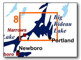
This is the main body of Big Rideau Lake, with Narrows Lock at the west end, the village of Portland on the east side and Tar Island (and also Murphys Point Provincial Park) at the north end. There is quite a bit of unsheltered open water, so paddlers, particularly canoeists, should ensure that they do a weather check to make sure the winds are light prior to heading out.
No specific route descriptions have been given for paddling the lake - you should explore it on your own. It's a big lake (hence the name) and has opportunities for several day paddles. The detailed map in this guide (which can be enlarged while viewing the PDF to any level of detail you desire) will allow for travel planning.
You can view or download the PDF file:
| (Clicking this link will open the PDF. You can also just right mouse click the above link and use "Save Target As" to send the PDF directly to your computer.) |
")
Water Access
Big Rideau Lake: The are five points of access to this section of Big Rideau Lake; Narrows Lock, Hudson Bay ramp, Portland Public Ramp, MacDonald Bay ramp and the ramp in Murphys Point Provincial Park.
At Narrows Lock it is a short portage to the canoe/kayak dock. The Hudson Bay ramp (44° 41.860'N - 76° 16.360'W) can be accessed from either McCann Rd (off of Narrows Lock Road) or Big Rideau Lake Road (off of Hwy. 15). It is located at the foot of Big Rideau Lake Road and consists of a grated steel ramp with limited roadside parking. In Portland, there are two public options. There is the public ramp right in town at the foot of St. Mary’s Street (44° 41.935'N - 76° 11.550'W). Just to the north of town, there is a public ramp in MacDonalds Bay (44° 42.655'N - 76° 10.580'W). Portland is also home to two large marinas; Bayview Yacht Harbour and Len’s Cove Marina. Just north of the map for this section (map 8) is the ramp in Murphys Point Provincial Park (44° 46.815'N - 76° 13.030'W) – it is shown on map 9.
Facilities
Lodging: If you're paddling and camping, the lockstations are a good choice for camp spots (a camping fee applies). There are also a few campgrounds, many B&Bs and hotels (in Westport, Newboro and Smiths Falls). For information about local accommodations see: www.smithsfalls.ca, www.villageofwestport.ca and www.rideau-info.com (this website).
Supplies: Local sources for supplies are the villages of Elgin (off Hwy. 15 opposite Davis Lock Road - grocery, pharmacy and hardware), Westport (grocery), Portland (grocery) and Smiths Falls (full services).
Big Boats
You'll be sharing the Rideau with big power boats (cruisers). The Rideau is generally not a crowded waterway and often you'll find the large boats in "packs" - travelling from lock to lock - once they pass by you won't see any for awhile. Some of these boats can generate a large wave. The general rule for a paddler and large waves is to meet them head on, this can actually be fun in a kayak (not as much fun in a canoe).
The main navigation channel is shown on the map as a blue dashed line - this is where the big boats will be travelling. So, if you wish to avoid these, pick a route away from the navigation channel. Many paddlers prefer paddling near shore, it's more interesting (i.e. wildlife, cottages) and it keeps you farther away from the waves produced by big boats.
There are several "no wake" zones on the Rideau - these have been marked on the maps. Boaters within these areas are supposed to be travelling at a slow enough speed (less than 10 kph) that their boat doesn't generate any potentially damaging or dangerous waves.
Wind
A question often asked is which way does the wind blow? The prevailing wind, powered by the jet stream, is from the southwest. That's about the only rule of thumb. If a front is moving in then the wind can come from any direction. I've been on several paddles where I've been paddling into the wind on the way out in the morning and into the wind on the way back in the afternoon because the wind swung around 180 degrees (for some reason it never seems to work the other way around - at your back both ways). So, if you're going to travel the entire Rideau, going from Kingston to Ottawa improves the odds of having the wind at your back - but be prepared for anything.
Etiquette
Your trip planning should include a "leave no trace" approach - carry out what you carry in. Many areas are un-serviced (no garbage cans) - so plan to be self-contained. The lockstations provide waste disposal facilities.
Preparation & Safety
Please read the trip planning information on www.rideau-info.com/canal/paddling/. While these lakes are easy paddling, normal paddling preparations should be made (all required safety gear, maps, food, water, first-aid kit, etc.). Zebra mussels are present in many areas along the Rideau, so a pair of water shoes (to avoid cut feet) is recommended.
Please take all normal safety precautions, including checking the weather forecast before you head out and making sure that someone on shore knows your planned travel route and itinerary.
Navigation
While the Rideau is generally easy to navigate, taking along a set of maps is a must (in addition to any GPS you might have). Although the map in this guide is an accurate 1:50,000 representation of the waterway (when printed to 8.5" x 11"), you may also wish to also have the 1:20,000 hydrographic chart for this section (Chart 1513). For power boat navigation, the charts are an absolute must (the map in this guide should not be used for power boat navigation). The charts are also very handy for the paddler, since they show the Rideau in great detail, including depths (which can be helpful when looking for wildlife habitat or just interesting places to paddle).
The charts also show all the navigation buoys. These are all numbered (red buoys have even numbers, green buoys have odd numbers) and so can be used as an aid in locating yourself on the map when you're on open water. A subset of those buoy numbers have been included on the paddling guide maps.
For those wishing to go off the beaten path or want to know more of the topography and geographic features of the surrounding countryside, the 1:50,000 NTS maps for this section are 31C/9 and 31C/16.
Distances:
Circumference distances are approximate, following the main shorelines & bays. The navigation channel is shown on the map.
- Narrows Lock to Murphys Point Provincial Park (ramp) along the navigation channel = 11.2 km (7.0mi)
- Narrows Lock to Portland along the navigation channel = 9.5 km (5.9 mi)
- Portland to Murphys Point Provincial Park along the navigation channel = 9.5 km (5.9 mi)
- Narrows Lock to Colonel By Island = 7.0 km (4.3 mi)
- Portland to Colonel By Island = 4.7 km (2.9 mi)
- Colonel By Island to Murphys Point Provincial Park = 5.5 km (3.4 mi)
- Big Rideau Lake (Narrows Lock to Rocky Narrows) Circumference: = 88 km (55 mi)
The Lakes
Big Rideau Lake
In the pre-canal area this was a single lake that stretched from Westport to Stonehouse Island (Stonehouse Point at the time). The dam at Poonamalie raised the water in the lake by about 6 feet (1.8 m). The lock and dam and Narrows created the western end of the lake into a separate lake (Upper Rideau Lake). The lake has a maximum depth of 330 feet(100 m) with an average depth in the western part of the lake of about 100 feet (30 m) and in the eastern part of about 40 feet (12 m).
The western side of the lake features a large exposure of granite (the Rideau Lake Pluton) and much of the northern shoreline marks the trace of the Rideau Lake Fault.
The land bordering the lake is mostly privately owned (the exceptions being federal land in the vicinity of the locks, Colonel By Island (federal), Murphys Point Provincial Park (provincial - 1243 ha) and the Portland Bay Conservation Area (provincial - tiny). Most of the lake has moderate density cottage and summer home development.
The Locks
Most Rideau lockstations offer facilities such as washrooms, water, recycling cans, waste cans and picnic tables. Most also allow camping for paddlers travelling the Rideau for a modest camping fee. Paddlers can portage the locks for free, but you owe it to yourself to lock through at least one lock in order to get the full experience of paddling the Rideau Canal. See www.rideau-info.com/canal/fees.html for the current fee schedule.
Points of Interest (listed south to north)
Narrows Lock: The lockstation here has a single lock (lift of 0.8 m /2.5 ft). It is located on a narrow spit of land, originally known as First Narrows, where the width of the channel in this area prior to the canal being built was only about 30 m (100 ft). For a short time it was used as a ford, connecting to a road (bridle trail) that led to Perth. By the time of lock construction (late-1820s) this path was out of use. The lift of the lock used to be about 4.8 feet (1.8 m) but the rebuilding of the dam at Poonamalie has raised the level of Big Rideau Lake, lowering the lift at Narrows to its present day 2.5 feet (0.8 m).
The lock was excavated into the bedrock of the spit, with the waste weir positioned near where the original channel existed. The spit was raised (dammed) to impound more water. A blockhouse, one of only four on the Rideau, was built here in 1832 to protect the lock. It is used today as the lockmaster's office (and public washrooms). The reason this lock is here, in the middle of a lake, is a story of disease and geology as recounted in Tales of the Rideau.
An interesting feature of this lock and also of Newboro Lock is that both were built without breastworks (an upper foundation). Colonel By didn't intend for these locks to be permanent. He thought that when conditions and technology permitted, his original plan, of simply having the isthmus at Newboro crossed by an open cut, with no locks here and at Newboro, could be implemented.
Big Rideau Lake: As with Upper Rideau Lake, Big Rideau Lake is a contrast of topography with the large granitic (syenite and monzonite) exposures on the west shore, low lying flat lands on the south shore (generally Paleozoic sandstones) and a bit more topography with Precambrian marble (crystalline limestone) on the east shore. The Rideau Lake Pluton (a large rounded area of igneous rock) is Precambrian, between 1.06 and 1.09 billion years old. It intrudes into older (1.3 billion year old) marbles and quartzites. Running along the west edge of the lake is the Rideau Lake Fault - the cliff faces that can be seen just north of Narrows are due to this fault. In the northern region of the lake (very generally in the area of Otty Lake and west of Nobles Bay - see Map 9) there was quite a bit of small scale mining done in the late 1800s and early 1900s, primarily for phosphate (apatite) and mica, plus a bit for graphite. See the maps in the Geology of the Rideau Canal section.
The lake has a long history of cottaging (from the 1870s) and there are some lovely old cottages to be seen along the route, a few of these are identified in the text below.
Donovans Point: An interesting part of local history is that it tends to get clouded with anecdotal tales - people, places and time periods get mixed up and erroneous conclusions are drawn. We have two such tales for Big Rideau Lake, that of Donovans Point and that of Murphys Bay. The tale for Donovans Point is that an Irish canal worker fell sick and on his deathbed requested that he be returned to Ireland so that he could be buried in Irish soil. There was no money to return him to Ireland, so instead a small plot of land was consecrated as being Irish and he was buried on the Rideau, in "Irish soil." A much more embellished version of this fictional tale appeared as a factual article in the Sept 2, 2007 edition of the Ottawa Citizen.
This tale has its roots in the burial of Dennis Donovan. Dennis, born in about 1795, immigrated to Canada from County Cork, Ireland. He may have ended up working on the Rideau Canal (not substantiated, there is no actual evidence for this). In 1842, he bought 50 acres of land in the area near Donovans Point. He and his family operated an apple orchard and truck (market) garden in this location. He died on December 18, 1851 (suicide) and was buried on his property. When his widow and son sold the property in 1860, it was for the entire 50 acres with the exception of a small parcel, 9 feet long by 6 feet wide, the burial place of Dennis Donovan. One story (not verified) goes that the deed for this 9 foot by 6 foot wide plot was given to the City of Cork in Ireland. These are the roots of the fictional "Rideau Canal worker buried in Irish soil" story. Donavan's headstone was found in 1970, it read "DENIS DONOVAN departed this life Dec. 18, 1851 aged 56 years, a native of the County Cork, Ireland."
Murphys Bay: The tale here is that this was the original location for the route of the Rideau Canal - that the plan was to do a canal cut from here, cross country via Crosby, to Newboro Lake. It is said that a warehouse and wharf were constructed here at that time in anticipation of the canal coming through. While these structures may have been built, they certainly weren't to service a canal in this spot - the surveys and plans for the Rideau Canal in this area always showed it going through First Narrows and over the Isthmus (Newboro). There were never any plans to take it by way of Murphys Bay.
Murphys Bay also holds a role in the settlement of Perth in 1816. It was named after David Murphy, who had a farm here, but there was an earlier settler in this area, referenced as “old man Lindsay” in an 1879 book, in 1816 he would have been young man Lindsay. One of the earliest maps of the region, Joshua Jebb’s 1816 map, shows the only road in the area to “Lindsay’s,” located at the head of Murphys Bay. The story of the settlement of Perth says that Lindsay operated a large scow and that he transported settlers in April 1816 down Rideau Lake to a landing in Beveridge Bay. We also have an account from John Kilborn (a young, 21-year-old military officer in 1816) that he escorted the settlers to Rideau Lake and “had to cut a road the last three miles, to reach the lake.” He says the location they ended up in is that of today’s Portland. Their actual destination was Old Landing, a spot a few hundred metres east of today' downtown Portland.
The most likely scenario is that Lindsay overwintered his scow in the sheltered Old Landing Bay and this was the destination of the new road. The actual landing is now underwater, near the east side of Sheep Island. The settlers were then taken down Rideau Lake to a spot in Beveridge Bay (near where the locks are today) where they disembarked and went overland to the Tay River at a point above the lower set of rapids in the river, where they continued by scow into Perth, arriving there on April 17, 1816. We can imagine the trepidation of these settlers as they headed out onto the waters of Big Rideau Lake to make a new life for themselves in the newly established community of Perth.
Portland: This small community features two large marinas plus a public docking area. It has services such as a grocery store and bank. Originally known as Old Landing, it was settled in the early 1800s with a community forming by the early 1820s. In 1833 it was renamed Portland in honour of William Henry Cavendish Bentinck, the 3rd Duke of Portland. A feature building in the village is the Emmanuel Anglican Church, built in 1862, located at the south end of the village. A heritage walking tour brochure of the village is available in the village or on-line.
Colonel By Island: This is an island owned by Parks Canada. Paddlers can camp here (for a fee). There is a 3 km long hiking trail looping around the island. The two "inland" lakes, Long Island Lake and Lost Lake, make for nice sheltered paddling.
The island has an interesting history. It was originally known as the "Isle of Guernsey" and was used as a cow paddock. The first building, a hotel, was built by R.G. Harvey in about 1889. Harvey was one of the entrepreneurs behind the Brockville, Westport & Sault Ste Marie Railway. Despite the name, the actual railway, built between 1886 and 1888, only made it from Brockville to Westport (the company went bankrupt in 1894). This first hotel appears to have been partially or completely burned down in 1889 (shortly after it was built).
In 1893, the property was purchased by a syndicate, mostly men working for the CPR. It's a bit unclear whether there was a building on the site or if they built a new lodge. It was operated as the CPR Angler's Club (or just Angler's Club) with membership limited to 100. To service the club, they had a fast steam launch stationed in Smiths Falls.
Sometime in the early 1900s, I.G. Ogden, the vice-president of the CPR, took over the lodge to use as his summer cottage. It burned down in the fall of 1915 and 1916 found Ogden busy building a new cottage, called the "Angler's Inn." This building was being "fitted with all modern conveniences," including a power plant to generate electricity and pump water.
The Angler's Inn was still there in 1920. It seems to have fallen out of use sometime in the 1920s.
The flat roofed building that you can see today on the Island is "Wag's Lodge," built by Danny Arnstein (co-owner of Yellow Cab in New York and Chicago) in 1949-50. The cottage features two massive "peanut rock" fireplaces and "driftwood plywood" walls. It was designed by architect Horace Roberts of Westport. Danny Arnstein had a number of famous visitors to the island including actor David Niven. Arnstein passed away in 1960 and the island passed into new hands. It was sold by its last private owner, Gerry Livingston, to the Government of Canada in 1979.
Other Islands: Islands served many purposed on the Rideau. In the mid-late 1800s, many of them were used for cattle grazing (no fences required) and some were farmed (potatoes were a favourite crop). Cottaging on the islands of Big Rideau Lake started in the late 1800s and several of the present day cottages that you can see date back to that time. Those who like interesting cottage and boathouse architecture will have a great time paddling along the shoreline of the lake and to the various islands. For a history of several of the cottages on Big Rideau Lake visit the library in Portland and have a look at the book Rideau Passages by D. Jane Moore (1982). A bit of island history, much taken from Moore's interesting book, is presented below (going from west to east).
Grindstone Island: This was the summer home of Admiral Sir Charles E. Kingsmill, the first head of the Canadian navy (the Canadian Naval Service which later became the Royal Canadian Navy). The navy was founded in 1910 and he served as its head until 1920. He acquired Grindstone Island in 1914. He passed away here in 1935 and is buried in the Emmanuel Anglican Cemetery in Portland.
The name derives from the fact that grindstone (sandstone) was mined here in the 1860s. Talc mining was also done here between 1893 and 1999, by the Sparham Roofing Company of Montreal. They were shipping the talc to Montreal for use in the manufacturing of roofing. To quote geologist Hugh Spence in 1922 “The workings consist of a single, almost circular, pit, opened in the east face of the low buff fronting the lake. This pit measures 75 feet (23 m) across, and has been carried down to lake level, with a depth of about 25 feet (8m))”. Some small scale graphite mining was also done on the island in the early 20th century.
In 1963 the island was leased for $1 per year by the Canadian Friends Service Committee (CFSC), the peace and justice social organization of the Quakers. They set up a peace retreat and hosted dozens of workshops and gatherings each year. When the island was put up for sale in 1973 they purchased it and continued to run the retreat until 1990.
A 6 acre part of the island is now the Lady Kingsmill Nature Reserve (Rideau Waterway Land Trust property).
Tower Island: The original cottage and tower on this island likely date back to the early 1900s. It has provided a visual landmark on the lake for many years.
Big Island: When the Rideau Canal was flooded with the building of dams (the slackwater system), forested land was flooded. When these trees died, they remained standing. Dead standing trees are used by the Great Blue Heron as a nesting spot (they build a nest of sticks at the top of the dead tree). By the mid-1800s there were thousands of herons (and also many osprey) nesting in the drowned forest lands of the Rideau. One such spot was Big Island, where the shallow "lake" on the west side of the island was host to many nests. Local history records two residents, Ernie Seward and Sim Scovill, once (likely in the late 1800s) counting over 550 heron nests in this spot.
Cow Island: This island is owned by the Big Rideau Lake Association, purchased by them in 1954. The original cottage on the island was built by the Gallagher family of Portland in the 1890s. The present building was constructed in 1962 by the BRLA.
Lands End: The point of land by Exe Island was the location of Garrett's Rest - a summer hotel built in about 1889 by S. Garrett of Smiths Falls. It had about 20 rooms for guests and at one point cabins were built on Exe Island to accommodate more visitors. The Smiths Falls Record in 1897 described Rideau Lake and Garrett's Rest: "It is one of the most delightful spots in all Canada. For boating, sailing, fishing and scenery it has no equal. The accommodation at Garrett's Rest is number one. The house this year has been renewed with in and without and presents a charming aspect. The price is extremely moderate and the host and hostess the most genial and obliging to be found anywhere."
The "Palace Steamers"; Rideau King and Rideau Queen, both had Garrett's Rest as a scheduled stop. A 1913 brochure shows accommodation at Garrett's Rest to be a bargain at only $1.00 to $1.50 per day. Other hotels in the regions such as the Hotel Kenney at Jones Falls, the Lake Opinicon Club House (the Opinicon) at Chaffeys Locks and The Fisherman's Rest in Westport were charging from $2.00 to $3.00 per night. The last owner, Albert Gallagher, died in 1934 and the building deteriorated, eventually being torn down in about 1946.
Wedding Cake Cottage: As you travel along the east shore of the lake from Lands End to Fancy Free, you'll be sure to notice the Wedding Cake Cottage, built about 1880. It was one of two of this unique style of building built on Rideau Lake, the second one used to be at Rideau Ferry, but it was destroyed (either burned or taken down) in the early 2000s, so this building remains as the only example of this style of architecture on the lake.
Fancy Free: The oldest standing cottage on the lake, the original cottage dates back to the 1870s. It was built by the Washburn family who lived in Smiths Falls. Although expanded a bit over the years, it still retains many of the features of the original building.
Muskrat Hole: On the west side of the lake you'll see a large building at the entrance to Muskrat Hole. This is the site of a failed business venture, Rideau Lakes Vacations, that set up shop here in the 1980s. They generated a great deal of controversy on the lake since, in addition to the lodge, they planned to have 56 large (40-foot) houseboats available for rent (parked in Muskrat Bay). They operated for a few years and then went bankrupt. The property was privately purchased in 1998.
Little Boys Camp: The island in front of Muskrat Hole is the site of Little Boys Camp, built by Charles Parker in 1908. Parker used to entertain many of his American friends here, and, according to local lore, the spot was named due to these men acting like "little boys."
Murphys Point Provincial Park: This is a large provincial park with many interesting features. For the paddler, there are several boat-in campsites (including a couple of canoe/kayak only camping spots). It also features a number of interesting hiking trails (interpretive brochures are available in the park), the historic Silver Queen Mine (a phosphate and mica mine that operated from 1903 to 1920), old homesteads and an historic sawmill site (dating back to the 1820s). You can do a loop trip through the park from Hoggs Bay to Loon Lake to Nobles Bay and back to Hoggs Bay (12 km with 2 portages). The park is located on a beautiful spot on Big Rideau Lake and well worth a visit.
Route Suggestions
No specific route suggestions have been provided - but it is worth spending some time on the lake. If you are travelling through the Rideau, I'd recommend taking an extra day with a diversion to Portland and include in that a visit to the central group of islands (area from Long Island (incl. Colonel By Island) to Big Island. This island tour can also be done as a day trip by launching from Portland.
Geology
As you paddle the Rideau Canal, the route you follow is defined by its geology. Geological highlights have been included in the Points of Interest listings and a general geological history of the route can be found on the Geology of the Rideau Page.
Wildlife Viewing
A section about wildlife viewing, what you might expect to see on your Rideau journey, has been included in text form in the PDF. A version of this information, that includes photos of some typical Rideau wildlife, can be found on the Fauna of the Rideau Page (in the ecology section of this website).
Errors
If you find any errors or omissions in this guide, please let me know (rideauken@gmail.com) and I'll get them fixed.
Terms of use
This guide may be freely used for personal purposes. Have fun on your Rideau paddling adventure.
Commercial use is not allowed in whole or in part without express written permission.
©2010- Ken W. Watson, All Rights Reserved.
You can view or download the PDF file:
| (Clicking this link will open the PDF. You can also just right mouse click the above link and use "Save Target As" to send the PDF directly to your computer.) |
|