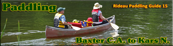
Paddling the Rideau River from
the Baxter Conservation Area to Kars N.
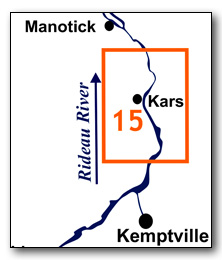
This is an easy paddling river section of the Rideau River, part of The Long Reach, a section of the Rideau Canal uninterrupted by locks. The map included in this guide can be enlarged (while viewing the PDF) to any level of detail you desire as an aid for travel planning.
You can view or download the PDF file:
| (Clicking this link will open the PDF. You can also just right mouse click the above link and use "Save Target As" to send the PDF directly to your computer.) |

Water Access
Water access in this section is available in Kars and at W.A. Taylor Conservation Area. Kars offers two launch points, a dock and ramp on the Rideau river (45° 09.010'N - 75° 38.650'W) and a ramp in the municipal recreation area (45° 08.890'N - 75° 39.070'W). The latter is the easiest for the paddler, a generally quiet gravel ramp with lots of parking. The W.A. Taylor Conservation Area has a paved ramp (45° 08.000'N - 75° 38.070'W) plus all the normal conservation area amenities. You can also launch (fee) at Long Island Marine, just north of Kars.
Facilities
Lodging: There are no official campgrounds in this section. Long Island Marina may allow camping (they have in the past), but best to check with them first: www.longislandmarina.ca There are a few B&Bs in the general area, plus a hotel (Merrickville), motel (Kemptville) and a host of accommodations in Ottawa. For information about local accommodations see: www.ottawatourism.ca and www.rideau-info.com (this website).
Supplies: A local source for supplies is the town of Kemptville which has which full facilities (grocery stores, pharmacies, hardware stores).
Big Boats
You'll be sharing the Rideau with big power boats (cruisers). The Rideau is generally not a crowded waterway and often you'll find the large boats in "packs" - travelling from lock to lock - once they pass by you won't see any for awhile. Some of these boats can generate a large wave. The general rule for a paddler and large waves is to meet them head on, this can actually be fun in a kayak (not as much fun in a canoe).
The main navigation channel is shown on the map as a blue dashed line - this is where the big boats will be travelling. So, if you wish to avoid these, pick a route away from the navigation channel. Many paddlers prefer paddling near shore, it's more interesting (i.e. wildlife, cottages) and it keeps you farther away from the waves produced by big boats.
There are several "no wake" zones on the Rideau - these have been marked on the maps. Boaters within these areas are supposed to be travelling at a slow enough speed (less than 10 kph) that their boat doesn't generate any potentially damaging or dangerous waves.
Wind
A question often asked is which way does the wind blow? The prevailing wind, powered by the jet stream, is from the southwest. That's about the only rule of thumb. If a front is moving in then the wind can come from any direction. I've been on several paddles where I've been paddling into the wind on the way out in the morning and into the wind on the way back in the afternoon because the wind swung around 180 degrees (for some reason it never seems to work the other way around - at your back both ways). So, if you're going to travel the entire Rideau, going from Kingston to Ottawa improves the odds of having the wind at your back - but be prepared for anything.
Etiquette
Your trip planning should include a "leave no trace" approach - carry out what you carry in. Many areas are un-serviced (no garbage cans) - so plan to be self-contained. The lockstations provide waste disposal facilities.
Preparation & Safety
Please read the trip planning information on www.rideau-info.com/canal/paddling/. While these lakes are easy paddling, normal paddling preparations should be made (all required safety gear, maps, food, water, first-aid kit, etc.). Zebra mussels are present in many areas along the Rideau, so a pair of water shoes (to avoid cut feet) is recommended.
Please take all normal safety precautions, including checking the weather forecast before you head out and making sure that someone on shore knows your planned travel route and itinerary.
Navigation
While the Rideau is generally easy to navigate, taking along a set of maps is a must (in addition to any GPS you might have). Although the map in this guide is an accurate 1:50,000 representation of the waterway (when printed to 8.5" x 11"), you may also wish to also have the 1:20,000 hydrographic chart for this section (Chart 1513). For power boat navigation, the charts are an absolute must (the map in this guide should not be used for power boat navigation). The charts are also very handy for the paddler, since they show the Rideau in great detail, including depths (which can be helpful when looking for wildlife habitat or just interesting places to paddle).
The charts also show all the navigation buoys. These are all numbered (red buoys have even numbers, green buoys have odd numbers) and so can be used as an aid in locating yourself on the map when you're on open water. A subset of those buoy numbers have been included on the paddling guide maps.
For those wishing to go off the beaten path or want to know more of the topography and geographic features of the surrounding countryside, the 1:50,000 NTS map for this section is 31G/4.
Distances:
Circumference distances are approximate, following the main shorelines. The navigation channel is shown on the map.
- Map bottom to map top along the navigation channel = 14.0 km (8.7 mi)
- Baxter C.A. to W.A. Taylor C.A. = 4.5 km (2.8 mi)
- Baxter C.A. to Kars = 6.5 km (4.0 mi)
The Rideau River
The Rideau River is generally a slow moving river. There are no weirs or dams in this section. Zebra mussels are present. Aquatic vegetation growth is present in most sheltered areas with a depth of less than 10 ft (3 m).
Baxter Conservation Area to Kars N.
In the pre-canal era, the river was a few feet lower than it is today, water levels have been raised by the canal dam at Long Island.
This section is part of the Long Reach, the longest stretch of the Rideau Canal uninterrupted by locks. It extends 40 km / 25 mi from the Burritts Rapids Lock to the Long Island Locks. The river channel has a maximum depth of 12 ft (3.6 m). The water depth outside of the marked channel averages about 4 ft (1.2 m). The land bordering the river is all privately owned except for the Baxter Conservation Area and the W.A. Taylor Conservation Area. This section marks a transition from rural to urban development along the Rideau. The southern part offers a combination of summer home/cottage and natural (farm) frontage, while north of Kars you'll start to see suburban development.
I haven't included any off the beaten path suggestions, but those out for a day paddle or just taking time on the Rideau will wish to poke into the various inlets and creeks (usually the best areas for wildlife viewing).
The Locks
Most Rideau lockstations offer facilities such as washrooms, water, recycling cans, waste cans and picnic tables. Most also allow camping for paddlers travelling the Rideau for a modest camping fee. Paddlers can portage the locks for free, but you owe it to yourself to lock through at least one lock in order to get the full experience of paddling the Rideau Canal. See www.rideau-info.com/canal/fees.html for the current fee schedule.
Points of Interest (listed south to north)
The Long Reach: this section of the canal is part of the Long Reach, the longest section of the Rideau Canal uninterrupted by locks (40 km / 25 mi). The canal dam at Long Island, the next set of locks, raised the Rideau River in that location by about 8 m (26 ft), flooding it all the way up to the foot of Burritts Rapids and making the entire section navigable (the main rapids that were flooded were those at Long Island itself).
Baxter Conservation Area: This 68 ha Conservation Area features over 5 km of trails plus a sandy beach and picnic area. It is run by the Rideau Valley Conservation Authority (www.rvca.ca).
W.A. Taylor Conservation Area: This small Conservation Area features a launch ramp, picnic area and trails. It is run by the Rideau Valley Conservation Authority (www.rvca.ca).
James Island: Named after John James who farmed the island in the 1800s. The island was created by the flooding of the canal, the navigation channel follows the original Rideau River on the west side of the island.
Former Garlick's Wharfs: Just north of James Island, in the area of marker buoy N125, were the wharves of Richard Garlick. Richard and his family settled in this area in about 1823. Richard was primarily involved in the timber business. After the canal opened, he built wharves in this area to service steamers plying the Rideau (including his own, the Bytown), primarily to supply them with cordwood for their wood-fired boilers.
Former Lindsay's Wharf: On the west shore, in the area of marker buoy N118, was Lindsay's Wharf. James Lindsay and his family settled here in 1830. By 1832 he had built a large wharf that would serve steamers plying the Rideau for the next century. It was a busy place. By the late 1800s it would see local items such as potash, cheese, potatoes, eggs, salt pork, cattle, horses, and produce being loaded on steamers while goods such as tea, molasses, sugar and salt were unloaded.
Richardson Ferry: Just north of Lindsay's Wharf was the landing for a ferry service that operated from the 1860s until 1878 when a bridge was built (see Lorne Bridge below). It was set up mostly in response to a railroad being built on the east side of the river. People wishing to take the train at Osgoode Station had to cross the river - the ferry service met this demand.
Kars: Narrow tree lined streets, 19th century homes, and a tranquil rural atmosphere characterize Kars. The area was first settled in about 1820. In 1830, James Lindsay settled just south of here and by 1832 he had built a large wharf (see Former Lindsay's Wharf above). The building of the Rideau Canal provided a commercial boon, and a six street village was laid out and named Wellington. The early industry was lumbering and with vast forests extending to the west, Wellington became a busy shipping point. In 1856 the name of the community was changed to Kars. There was already a Wellington in Prince Edward County and so Kars was chosen to commemorate the British defence of Kars in Turkey in 1855 against a Russian siege. In 2001 Kars was amalgamated into the City of Ottawa.
Those wishing to stop in Kars can either use the public dock on the Rideau River, or, for a more sheltered spot, paddle a short distance up Stevens Creek to the gravel ramp in the Kars Recreation Area.
Lorne Bridge Crossing: The public dock on the Rideau River is part of the foundation of the former Lorne Bridge which crossed the river at this spot. The original bridge was built in 1878 and operated until 1961. It was similar in design to the current Brass Point Bridge, several spans leading to a timber swing bridge (located on the Kars side of the bridge). The bridge suffered two collapses, once in 1956 and again in 1957, both a result of trucks carry loads that were too heavy for the bridge. The bridge was removed after the fixed bridge downstream was built in 1961.
Kars Bridge: This fixed high level (6.7 m / 22 ft above the water) concrete bridge was built in 1961.
Geology
As you paddle the Rideau Canal, the route you follow is defined by its geology. Geological highlights have been included in the Points of Interest listings and a general geological history of the route can be found on the Geology of the Rideau Page.
Wildlife Viewing
A section about wildlife viewing, what you might expect to see on your Rideau journey, has been included in text form in the PDF. A version of this information, that includes photos of some typical Rideau wildlife, can be found on the Fauna of the Rideau Page (in the ecology section of this website).
Errors
If you find any errors or omissions in this guide, please let me know (rideauken@gmail.com) and I'll get them fixed.
Terms of use
This guide may be freely used for personal purposes. Have fun on your Rideau paddling adventure.
Commercial use is not allowed in whole or in part without express written permission.
©2010- Ken W. Watson, All Rights Reserved.
You can view or download the PDF file:
| (Clicking this link will open the PDF. You can also just right mouse click the above link and use "Save Target As" to send the PDF directly to your computer.) |
|