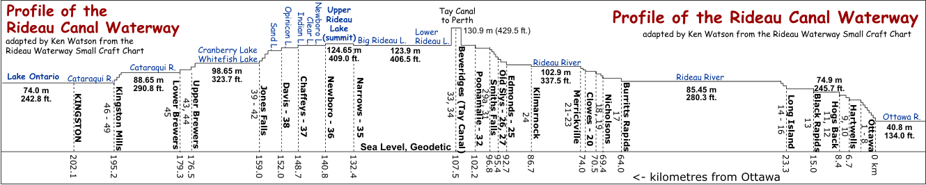
This graphic is a profile (longsection) of the Rideau Canal, showing how the locks and dams regulate the water levels between Lake Ontario (at 74.0 metres above sea level), the summit at Upper Rideau Lake (at 124.65 metres above sea level) and the Ottawa River (at 40.8 metres above sea level).
The watershed divide is at Newboro (a bedrock ridge separating Upper Rideau Lake from Newboro Lake). Water from Upper Rideau Lake flows north to the Ottawa River, water from Newboro Lake flows south to Lake Ontario (Kingston) and to the St. Lawrence River (Gananoque).
While Upper Rideau Lake is the highest part of the Rideau Canal, it is not the top of the watershed. Water flows into Upper Rideau Lake from higher up on the Rideau River Watershed and water flows into Newboro Lake from higher up on the Cataraqui River Watershed. For a look at the watersheds and how they changed with the building of the Rideau Canal see the watersheds section of the Rideau Route.
For specific information on the lift of each individual lock, consult the Rideau Waterway Statitics Page
If you want to print this image, it is best to save the image to disk, and then use a graphics program to print out the image in landscape mode. It is quite readable when printed in landscape mode on an 8.5" x 11" page. If you buy the hydrographic charts for the Rideau, you will find a version of this graphic on the chart cover. |