Samuel Clowes’ 1823-24 Survey
Each survey of the Rideau led to a greater understanding and more details about the route. This culminated in the pre-canal era with Samuel Clowes’ survey of the Rideau. In 1823, the Macaulay Commission, which was set up under an Act of the Provincial Legislature to investigate internal navigation in the province of Upper Canada, hired Civil Engineer Samuel Clowes to conduct a survey of the Rideau Route. Clowes was also tasked with preparing a cost estimate for making the route useable for a navigation depth of 7 feet (2.1 m). In 1824, the requirements were altered and Clowes was asked to prepare three estimates, for 4, 5 and 7 foot (1.2, 1.5 and 1.7 m) navigation depths.
Samuel Clowes, in the company of his son James, Provincial Land Surveyor Reuben Sherwood (acting as a guide), and one of the commissioners (unnamed), embarked on the survey in the spring of 1823. During that year they completed a detailed survey from Kingston to Newboro and then carried the line down the Rideau River. Clowes came back that winter to do some more detailed surveying of the lakes (on the ice) and then in 1824 completed his detailed survey of the Rideau Route down to the Ottawa River.
One of the first things he did in 1823 was to investigate the Irish Creek route and discount it as a possible canal route. According to his surveys, the height of land at the watershed divide on this route was actually 2 feet (0.6 m) higher than Rideau Lake. Also, to get sufficient water for continuous navigation, a 10 mile (16 km) long feeder canal would have to be constructed from Rideau Lake. This made the Rideau Lake route much easier and cheaper and that was the route that Clowes concentrated on.
His survey map adds more detail than provided by Jebb’s 1816 map and Clowes was the first survey of the Rideau Route to run levels (elevations). Clowes was still proposing an “old style” canal, with canal cuts and a tow path. Clowes proposed canal bypass cuts in several areas such as Kingston Mills, Smiths Falls, Merrick’s Mills and Rideau Falls. Interestingly, in one area he saw the advantage of using a slackwater system, the Cranberry Flood Plain. He had the working examples of Haskins’ mill dams which demonstrated how effectively and cheaply navigation could be achieved by flooding:
“At a moderate calculation it is supposed that the cost of a Cut at this place would not be less than £3,175 per mile – The distance is about nine miles and a half, of which one mile and a half would be rather favourable — The whole expense is therefore estimated in the aggregate for the nine miles and a half at £25,650. By the latter plan [dams at the Round Tail and at White Fish Falls] the water would be raised to a depth of seven feet over the whole surface of the flats to the foot of Jones’s Rapids. The expense of forming waste weirs at the Round tail and Whitefish falls, clearing the timber from the direct line of the canal on the flats, would amount to £725 — and as the difference between the two plans amounts to £24,925, the advantage of inundating the tract instead of cutting through it, obtains a decided superiority.”
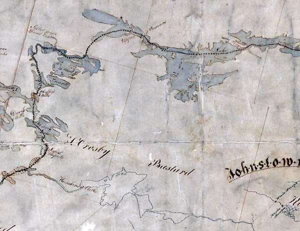 |
Clowes’ Map of the Rideau Route 1823-24 Clowes map remained the most accurate representation of the Rideau Route up until the late 1800s. During canal construction and in subsequent years, the system wide base map of the Rideau used was either Jebb's 1816 map or Clowes' 1823-24 map. On this map, the heavy dashed line is Clowes' proposed route for the canal. The stippled areas (lower left) are Clowes' representation of the flooding caused by mill dams.
"Sketch of the Water Communication from Kingston to the Grand River" by Samuel Clowes, 1823-24, Library and Archives Canada, NMC 11962
|
|