Final Canal Surveys
| |  |
| |
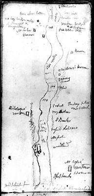
John Burrows’ survey sketch (looking south) of Cox’s, Nicholsons’ and Clowes’ rapids on the Rideau River in 1827
John Burrows Diary, City of Ottawa Archives, Image 21338.
|
When Colonel By arrived on the scene in 1826, he had Jebb’s and Clowes’ reports, maps and recommendations in hand. From the start, By proposed a full slackwater system and this decision was to forever change the geography of the Rideau. By’s decision appears to be in part for the same reason as Clowes’ suggestion for the Cranberry Flood Plain – it was faster, cheaper and easier to create navigation by flooding that it was to dig channels through the hard Canadian bedrock with the technology available in the 1820s. By also envisaged creating a steamboat canal, he did away with the concept of a tow path, By’s canal was going to be used by self-propelled vessels.
It was with steamboat navigation and a slackwater design in mind that the final reconnaissance surveys were done in 1827, primarily by John MacTaggart and John Burrows. A transcription of these surveys can be found in Edwin Welch’s book, Sights and Surveys. MacTaggart and Burrows investigated the navigation impediments (rapids) in detail, looking at solutions for how to create navigation through or around them. Many of these rapids were already partially flooded by mill dams, but their reports still provide some insight into what the Rideau Route would have looked like in the pre-canal era.
The canal building period is also a time when hundreds of detailed maps of the lock sites were done, including many by John By himself. These provide insights into the pre-canal geographic details of each lock site.
It was also in the canal building time period the first paintings of the Rideau start to appear. The Royal Engineers and many surveyors were trained in art. This was a time before the invention of photography, so the only human record available today of the appearance of the Rideau at that time are the written descriptions, maps and paintings. Although artistic liberties were often taken, these period paintings by the likes of Thomas Burrowes, John Burrows, and J.P. Cockburn are invaluable in helping to determine the appearance of the pre-canal Rideau.
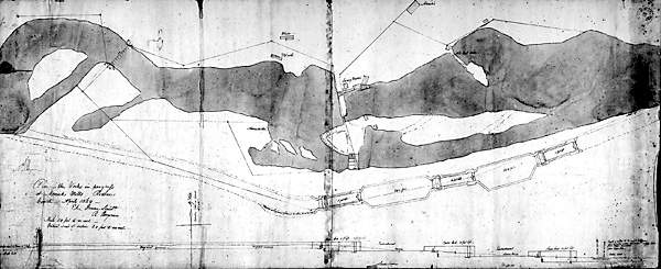 |
Merrickville Locks - 1829This canal construction map shows the geography at Merrick’s Mills in 1829. The Rideau River has been flooded upstream of William Mirick’s mill dam. Excess water is being diverted through a flood channel of the river (Merrick’s Snie). In order not to disturb Mirick’s mills, By’s plan was to cut a bypass channel around this section of the river, placing a canal dam upstream of Mirick’s dam, to provide a navigation depth of water into the canal cut. The three locks are spaced out to take advantage of the local topography. “Plan of the Works in progress at Merricks Mills Rideau Canal April 1829” by E.C. Frome, April 1829, National Archives of Canada, NMC 130251.
|
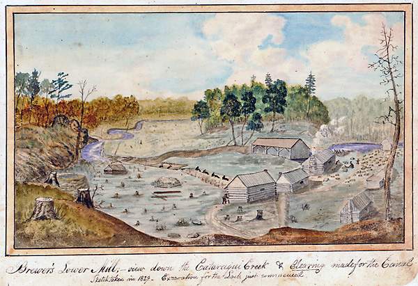 |
The Construction Camp at Lower Brewers in 1829This painting shows both the details of the pre-canal geography in this area and a typical Rideau canal construction camp. The meandering nature of the Cataraqui River is clearly visible. The proposed navigation channel has been cleared of trees. This area is now under about seven feet (2.1 m) of water from the flooding by the canal dam and embankments at Kingston Mills. The log houses are for the construction crews. The long building in the background is Brewer’s sawmill, which Colonel By decided to bypass with a short canal cut in order to allow its continued operation. In the painting, one can see labourers excavating the lock pit, removing material using wheelbarrows, and masons shaping stones (on right) for the lock. A lime kiln is located on the left side of the painting. Trees have been cleared around the lock site to help mitigate seasonal problems with malaria. “Brewers' Lower Mill;- view down the Cataraqui Creek & Clearing made for the Canal. Sketch taken in 1829. Excavation for the Lock just commenced,” by Thomas Burrowes, 1829. Archives of Ontario, C 1-0-0-0-67.
|
|