The Shaping of the Rideau
| |  |
| |
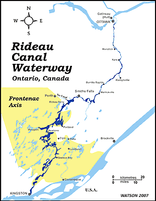
The Frontenac Axis
A neck of very old rocks of the Canadian Shield extends across the southern portion of the Rideau Route. This underlying geology is the reason for the lake development in this area. It not only helped to shape the geography of the region, but also the cultural landscape. Although initially extensively farmed, the poor soils and rugged topography of this area are now more suited to cottage/summer home development. Map by Ken W. Watson
|
The shaping of the landscape of the Rideau starts with the underlying geology. The southern section of the Rideau, from portions of Big Rideau Lake to Kingston Mills, is underlain by rocks of the Canadian Shield known as the Frontenac Axis. These are very old (Pre-Cambrian) rocks, often very hard, that form an area of topographic relief consisting of rocky hills, lakes and valleys. To the north and east of the Frontenac Axis are younger (Palaeozoic), generally flat lying sedimentary rocks. This area, through which the Rideau River runs, exhibits poor lake and stream development.
Some 90,000 years ago, the Wisconsin period of continental glaciation took hold. At its peak, 20,000 years ago, the Rideau region was under a kilometre of ice. The weight of the ice depressed the bedrock, in some cases pushing it down below the sea level of the day. It polished bedrock exposures, gouged out lake beds and left many gravel deposits. For example, Bacchus Island on Big Rideau Lake is a glacial drumlin (a gravel ridge elongated in the direction of glacial movement). As climate conditions changed, the glaciers started decrease in size, retreating to the north. This led to the next landscape change for the Rideau.
Ancestral Lake Ontario formed at the edge of the retreating glaciers. The outlet for the lake was still blocked by ice, so a very large lake, known as Lake Iroquois, formed (see map below). It lasted for about 500 years, from 12,500 BC to 12,000 BC. At its peak it extended as far north as Perth and Smiths Falls. Eventually there was a break in the glaciers to the east and this lake drained, eventually to the present day boundaries of Lake Ontario.
As the glaciers continued their retreat north, the St. Lawrence and Ottawa river valleys were exposed. The bedrock was depressed below sea level from the weight of the ice. This allowed waters of the Atlantic Ocean to fill the depressed area and mix with river waters and glacial meltwaters. This formed a brackish (partly salty) sea known as the Champlain Sea (see map below). This sea in the northern Rideau area lasted from about 12,000 BC to 11,100 BC and extended at least as far south as Rideau Ferry, perhaps to Nobles Bay of Big Rideau Lake. Evidence for this sea can be found in the sediments it deposited, including the Leda clay deposits found in the Ottawa area, many sea mollusc shells and even the bones of Beluga whales which have been found as far south as Smiths Falls.
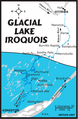 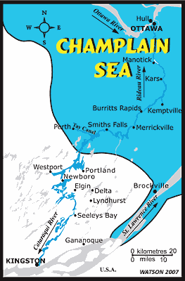 |
| These are rough representations of Glacial Lake Iroquois and of the Champlain Sea in the Rideau area. The blue on each map represents the area under water.
|
With the weight of the ice gone, the bedrock was rising, a process known as isostatic rebound. The rivers and lakes were establishing themselves as they would be seen in the immediate pre-canal era.
|