Jones Falls
After Smiths Falls, French paddled to the headwaters of the Rideau River, which in 1783 was a single large Rideau Lake. He portaged across the watershed divide at the Isthmus (Newboro) and put his “canoes into the River Gananoncoui.” On the morning of October 10, 1783, he proceeded south, doing a 1,500 yard (1,350 m) portage around Chaffeys Rapids and then another 1,500 yard (1,350 m) portage around Jones Falls. He camped that night at the foot of Jones Falls, near where the Hotel Kenney sits today.
| |  |
| |
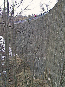
Stone Arch Dam at Jones FallsThis magnificent structure, which has stood unaltered for over 175 years, is best visited in person to be fully appreciated. Photo by Ken W. Watson, 2004
|
Jones Falls is similar to Hogs Back in that it exhibits a large landscape change brought about by the building of the Rideau Canal, and also because, like Hogs Back, there were no significant falls at this location in the pre-canal era. Rather it was a series of rapids that, in 1783, dropped 62 feet (18.9 m) over a distance of a mile (1.6 km). Samuel Clowes and John Burrows both referred to these as Jones Rapids, John MacTaggart as Jones’s Falls, and one report even use the descriptive “Long Falls.” By the time of canal construction at this site in 1827, the drop of the rapids had been reduced to 59 feet (18 m) with flooding of the foot of the rapids caused by the mill dams at Whitefish Falls (Morton) and at the Round Tail.
Jones Falls in the pre-canal era marked the head of the White Fish River which flowed to Lower Beverley Lake and from there to the Gananoque River. The head of this was a pre-canal Sand Lake, 8 feet (2.4 m) lower than the present day Sand Lake.
There were no mills at this location at the time of canal construction. It is unclear from the historical record why this is so. Charles Jones owned the land at the head of the rapids. Nancy Knapp owned the land that covered the main part of the rapids. Both were absentee landlords.
John Burrows, in describing Jones Falls in May 1827 stated “Landed at the head of Jones Rapids: walked down its east bank. The view of the Falls is awfully grand: the banks being very high and close. Some places are only chasms of 200 and 300 feet deep. It may be possible to make locks only by building piers and hanging gates. Some places it is only 50 feet wide; in the middle of which rushed down the foaming river. … The fall of water in Jones Falls is 61 feet: the distance one mile” (Welch, p. 25).
Today’s landscape at Jones Falls was brought about by the way the dam and locks were constructed. The canal era surveyors found a dry flood channel, Macdonald’s Gully, located on the west side of the river. Colonel By decided to build the locks in this gully, allowing them to be built “in the dry” (above the pre-canal water level - as he did at most Rideau lockstations).
The dam itself was placed partway up the rapids, in a rocky constriction just past the entrance to Macdonald’s Gully. This was an ideal spot to construct an arch dam, locking it into the bedrock walls of the river canyon. An interesting engineering note is that the dam was built with the use of sluiceways in the dam to allow the continued flow of the White Fish River. A lower sluiceway allowed the dam to be raised about half-way. Then a coffer dam was built at the head of the rapids (at Sand Lake) and this sluiceway was filled in. The coffer dam was released and the river water flowed through the second, higher sluiceway. When the locks were completed and a waste water weir had been created by blasting through a bedrock ridge, the second sluiceway was filled in using the same manner as the first, and the water rose to its present day levels.
Today, the “falls” that we see at Jones Falls, are the result of water flowing though the man-made waste water weir.
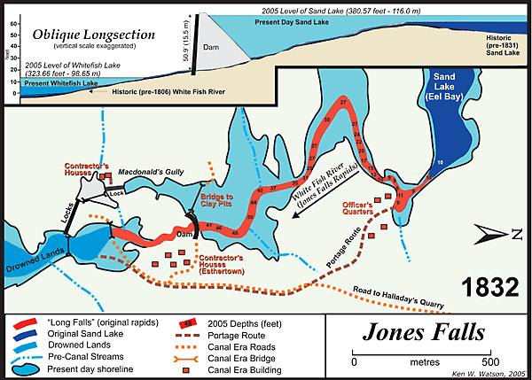 |
Geographic Changes at Jones Falls
This schematic shown above is a composite of two time periods, 1826 and 1832. It is split into two sections, the top is a long section (profile) view and the bottom is a plan (overhead) view.
The year 1826 is represented by the dark blue of Sand Lake, the red of the Jones Falls Rapids and the medium blue of the Drowned Lands. The original rapids extended to where the bridge below the lower locks is shown. But in 1826, mill dams erected at White Fish Falls (Morton) and the Round Tail (near Upper Brewers), had flooded the White Fish River, including the lower section of the Jones Falls Rapids. This is what the area looked like when Colonel By arrived on the scene in 1826.
During construction, there were two construction camps, one for the dam, one for the locks. The construction contractor was John Redpath and the workforce at this location was made up primarily of Scots and French Canadians. The locks were built in a dry gully (Macdonald's Gully) above the pre-canal water level. The dam was built partway up the rapids (which is why it isn't as high as the overall drop of the rapids). A road, built in 1827, led to Halladay's Quarry, near present day Elgin. The stones for the locks and dam were hauled over this road. The lighter blue with black outline represents the post-construction water levels. When the dam was completed in 1831, it flooded the rapids all the way back to Sand Lake (raising the level of Sand Lake by almost 8 feet (2.4 m)). The canal dam at Upper Brewers provided additional flooding of the Drowned Lands, creating today's Whitefish Lake.
|
|