Your location: Rideau Canal Home Page > History > The Rideau Route > Field Work – discovering the Rideau’s Past Today

Field Work:
Discovering the Rideau’s Past Today
| |  |
| |
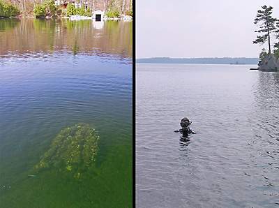
The "Rosetta" Stump in Sand Lake
The left panel is a view of the still rooted stump with a base 7.75 feet (2.4 m) underwater. The right panel is Jonathan Moore, a marine archaeologist with Parks Canada, standing on top of the stump. Photos by Ken W. Watson, 2005.
|
A brief pause while I describe some of the present day field work that went into discovering what the Rideau looked like prior to the canal being built. While the surveyors’ journals, maps and period paintings are invaluable tools in researching what the pre-canal Rideau, the determination of an exact flooding depth for each section of the Rideau and pre-canal topographic details required site investigations. The drowned stumps still present along the Rideau were once growing on dry land. The location and depth measurement of the deepest drowned stump that can be found in a lake, provides a measure of the depth of flooding, since that stump was a growing tree in the pre-canal era. The original tree could have been growing right at the waterline, or at some elevation above the waterline, so its depth measurement provides a minimum value for the depth of flooding.
In several areas, the bedrock at the head of a set of rapids can still be located and the elevation of this bedrock can be measured. This doesn’t work in all areas, in places such as Kingston Mills and Hogs Back the canal dams were built right over the top of the rapids. However depth measurements of the river channel above and below these locations can help in determining the original topography.
Even present day information about the elevation and depth of the upper and lower lock sills provides another piece of the puzzle. Colonel By preferred to build his locks “in the dry” – that is, built above the pre-canal water level. Pumping water by hand was a very laborious and costly exercise in the 1820s, and was to be avoided if at all possible. By’s slackwater design assisted in this goal of building in the dry since he could build his locks above the pre-canal water level and then his dams would provide a navigation depth of water over the sills of those locks. The elevations of those sills hasn’t changed appreciably since 1832, and their elevations and present day depth below water provide additional information on pre-canal water levels.
The original river channels still exist below the waters of the now flooded Rideau. The author was able to map the Jones Falls rapids above the dam, the White Fish River channel from Jones Falls to Morton, and a portion of the Cataraqui River channel near the Round Tail using a simple “fish finder” echosounder. The author also participated in a detailed survey of Colonel By Lake with an M.Sc. student from McMaster University, Lisa Sonnenburg and her thesis advisor, Dr. Joe Boyce. In this case, high tech gear, including a large bathymetric unit and a side scan sonar unit was used to map the bottom of Colonel By Lake in detail, revealing the original channel of the Cataraqui River.
|
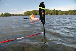 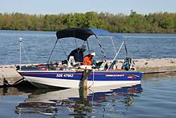 |
Field Work - Low Tech and High TechI generally employ low technology (affordable) ways of surveying sections of the Rideau, such as using my kayak paddle to measure the depth of a drowned stump (left photo). However, a year or so after I started my research, I was fortunate enough to be able to participate in the thesis field work for Lisa Sonnenburg's M.Sc. thesis under the direction of Dr. Joe Boyce of McMaster University. The right photo is my boat outfitted with 3 computers, GPS navigation, a large bathymetric (depth sounder) unit, a side scan sonar unit and a magnetometer. These tools were used to survey several of the southern lakes in 2005 - in this case, Colonel By Lake.
|
Comments: send me email: Ken Watson
©1996- Ken W. Watson
|