The Founding of Ottawa
and the
Start of the Rideau Canal
by
Ken W. Watson, 2026
This is a brief précis of events leading up to the founding of Ottawa and the start of the Rideau Canal on September 26, 1826. I wrote this in part to be show the chronology of events and to be able to put several pieces of first-hand information, in the form of documents and maps, for the public to be able to see in detail as part of this story.
Note: Details about the Rideau Route, including maps and transcriptions of the early surveys, can be found in my books Engineered Landscapes and The Rideau Route. Information about indigenous use and geographic changes due to mill dams in the Cataraqui River area can be found in my article The Indigenous Canoe Route via Hart Lake, A Geographic Evaluation. All are available as free PDFs in the Books and Reports section of the Friends of the Rideau website (www.rideaufriends.com/books-reports/).
The City of Ottawa, our nation’s capital, owes its existence to the Rideau Canal. This article is a very brief look of events that led to the founding of Bytown in 1826, renamed Ottawa in 1855, and made our nation’s capital by Queen Victoria in 1857. That selection was later ratified during Confederation of the Dominion of Canada in 1867.
The concept for a canal started after the War of 1812 with the need for a safe military supply route to Kingston, one that didn’t involve travel up the St. Lawrence River which bordered the United States and was vulnerable to attack. That route was from Montreal, up the Ottawa River and then down the Rideau Route to Kingston.
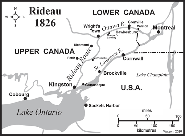
The Rideau Route was originally an indigenous water travel route from Gananoque on the St. Lawrence River to the Ottawa River at Rideau Falls, which started to see use after the last ice age. In the last ice age, which peaked 20,000 years ago, the Laurentide Ice Sheet covered this area under over 2 km of ice and depressed the entire landscape by 175m (575 ft).
As the climate warmed up 14,000 years ago the ice started to retreat and the land started to rise (isostatic rebound). Much of this area was then underwater from two flooding events. In the south, going as far north as Smiths Falls, an ice dam expanded Lake Ontario into Glacial Lake Iroquois. It lasted for about 1,000 years, draining back to the size of Lake Ontario about 12,500 years ago.
In the north, at that same time, as the glaciers retreated, the depressed land, which was below sea level, was flooded from the Atlantic Ocean. This formed the Champlain Sea formed in the northern part of the Rideau. That sea shrank as the land continued to rise. By 10,000 years ago the land had risen above sea level and the topography we see today was revealed.
| |
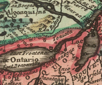 |
| | Tribal BoundariesThis map shows Algonquin territory in green and Haudenosaunee (then called Iroquois) in red, the boundary on the Rideau at that time (early 1700s) just south of the watershed divide at Newboro. The Rideau River is shown, it first appeared on maps in the mid-1600s.
From: Canada ou Nouvelle France Suivant les Nouvelles Observations by Pieter van der Aa, 1713 (based on an earlier 1703 map by Guillaume De L'Isle) |
Humans arrived in this area as early as 12,000 years ago on the heels of the retreat of the continental glaciers. It was a sub-arctic climate and those humans were following game animals such as caribou. There is some archaeological evidence, dating back 10,000 or so years ago of human presence on the Rideau Route. They were following a water route that went from Gananoque on the St. Lawrence River to the Ottawa River at Rideau Falls. There were many different cultural groups that used this route over the centuries.
By the time of European arrival into this region in the 1600s, there were two main indigenous cultural groups, the Anishinaabe group of culturally related indigenous peoples, including the Algonquin and Missisauga, and the Haudenosaunee, aka the Iroquois Confederacy, made up of several culturally related peoples. Early (1700s) European maps show a general dividing line in the Rideau Corridor to be the watershed divide at Newboro, with Alquonquin to the north and Iroquois to the south. There were no indigenous settlements in the Rideau Corridor, it was used as a travel way and as a hunting/gathering area.
The first full documentation (report and map) of the route by Europeans was the survey done by Lt. Gershom French in 1783. He travelled in 2 canoes from Montreal with an indigenous guide leading him up the Rideau River and then down the Ganananoque River. At that time there was no direct water connection to the Cataraqui River. The reason for French's survey was not for a canal route, but rather to evaluate the character of the land to see if it was suitable for Loyalist settlement. The Rideau Route was now fully known to Europeans.
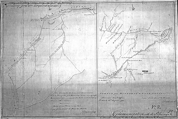 |
| This the map showing French's 1783 survey. Full details can be found in the book The Rideau Route. "Communication with the St. Lawrence & Ottawa Rivers by the Rivers Petite Nation & Rideau", William Chewitt, 1794. Archives of Ontario, AO 1336 |
In the early 1800s, the route changed due to the activities of local settlers. As early as 1803, Lemuel and Carey Haskins built a mill dam at the location of today’s Morton Dam and started to flood waters from the White Fish River, which flowed from Jones Falls to Lower Beverley Lake, down to the Cataraqui River. At that time the Cataraqui River was a meandering creek with its headwaters in Loughborough Lake. There was no direct water connection between the White Fish River and the Cataraqui River, the area in between was a flood plain, dry (above water) in summer.
By 1816 (likely closer to 1803), a second mill dam built by the Haskins at the Round Tail (north of Upper Brewers), flooded the area in between that dam and the White Fish River under 6 feet of water. The flooding between the White Fish River and the Cataraqui River provided a direct water connection to Kingston along the same route the Rideau Canal follows today. This was the route the next surveyor, Lt. Joshua Jebb, a Royal Engineer, was to take in 1816. Jebb noted 6 feet of flooding at the site of the Round Tail Dam and called the area of today’s Whitefish Lake, “Land Overflowed”. Colonel By later referred to this area as the Drowned Lands.
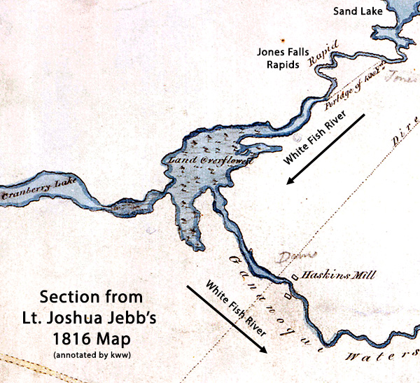 |
| This annotated section of Joshua Jebb's 1816 map shows Haskins' mills, today's Morton, and the Land Overflowed area, today's Whitefish Lake. Full details can be found in the book The Rideau Route. Section from "Plan of the Water Communication from Kingston to the Grand River" by Lt. J. Jebb, July 8, 1816, Library and Archives Canada, NMC 21941 2/3. |
In 1819, the political will for Britain to build the Rideau Canal, as part of an overall defensive strategy for Canada, started to build. Proponents included two powerful figures, the Duke of Richmond (who was to die that year) and the Duke of Wellington, who was later to become Prime Minister of Britain.
In March 1819, the Duke of Wellington, who was then Master-General of the Ordnance Department, wrote a Memorandum On The Defence Of Canada (PDF), to Lord Bathurst who was the Secretary of State for War and the Colonies. That memorandum included a recommendation to build the Rideau Canal.
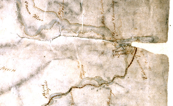
In 1823 and 1824, a civilian surveyor Samuel Clowes, working for the Macauley Commission, which was set up by the government of Upper Canada to investigate inland navigation, did a more detailed survey of the route, including taking levels. He submitted a report for three depths of canals; 4, 5, and 7 feet deep. However, the government of Upper Canada was not interested in building the Rideau Canal since they didn’t see it as commercially viable, so it became up to Britain to do it.
 |
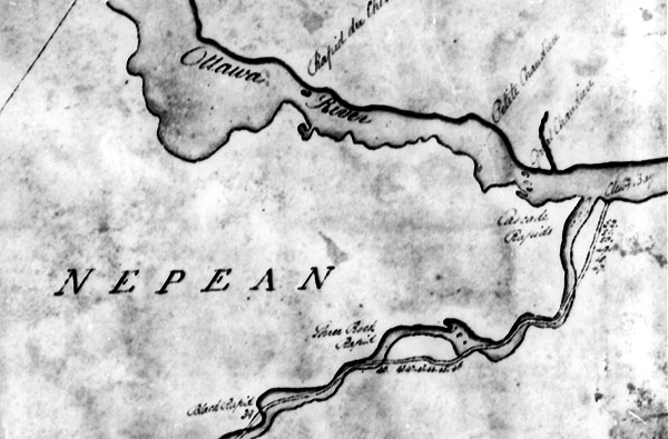 |
These two maps show Clowes' canal plans near Ottawa (Black Rapids to the Ottawa River). The top map is one of Clowes' original maps and the bottom is a copy made by the Board of Ordnance, similar to what Colonel By and his staff would have used.
Clowes ran canal cuts around obstructions such as the rapids near Hogs Back and took his canal to today's Governor Bay, which he called Clowes' Bay on his map.
In this section of his map we see 7 locks (locks 40 to 46) in a canal cut bypassing Three Rock Rapids and Three Island Rapid (Hogs Back), and another 6 locks (locks 47 to 52), in a canal cut leading down to the Ottawa River. The final canal built by Colonel By had 47 locks (46 lift locks and 1 guard lock).
Top: "Map of the proposed Canal for uniting Lake Ontario with the River Ottawa by way of the Rivers Catarcquay, Gananoque and Rideau surveyed in the years 1823 and 1824 by Mr. Samuel Clows Civil Engineer and compiled from the minutes of actual survey by Mr. Reuben Sherwood, Land Surveyor, under the directions of the Commissioners of internal navigation.", 1824, by Reuben Sherwood, Library and Archives Canada, NMC 11962.
Bottom: “Plan of the Proposed Canal from Kingston on Lake Ontario to the Ottawa River”, Board of Ordnance copy, 1827, Library and Archives Canada, NMC 11306
|
In September 1825, Major-General James Carmichael Smyth produced a report with recommendations for the Defence of Canada, including building the Rideau Canal. Work on the Ottawa River canals was already underway; the Rideau Canal would provide the final part of that backdoor water link to Kingston.
Smyth based his recommendations on the information from Samuel Clowes’ reports, including his cost estimates. Smyth recommended that Clowes' 5-foot deep canal estimate be adopted, with the modification that the locks be increased in size from 80 feet to 108 feet (33 m) long, with a width of by 20 feet (3 m). To compensate for the increase in lock size he added £500 per lock, increasing Clowes' estimate of £145,802 to £169,000.
 |
| Clowes' three estimates from the Macauley commission's 1825 report. The middle estimate of 145,802 pounds, 7 shillings and 8 1/2 pence was for Clowes' 5 foot deep canal. From Upper Canada Sundries - C-4614 |
In the spring of 1826, the Duke of Wellington, who was Master General of the Board of Ordnance at that time, approved of Lieutenant Colonel John By being placed in charge of building the Rideau Canal. By, a Royal Engineer, who was on half-pay retirement (inactive service) was returned to active service and given orders to proceed to Canada. He was given a great deal of autonomy, the Rideau Canal would be his project.
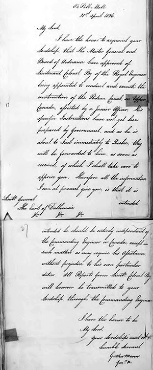
General Mann's Letter to Lord Dalhousie, Governor-in-Chief of British North America, with the Appointment of Lt. Colonel John By |
 |
84 Pall Mall
21st April 1826
[To Lt. General, The Earl of Dalhousie]
My Lord,
I have the honor to acquaint your Lordship that the Master General and Board of Ordnance have approved of Lieutenant Colonel By of the Royal Engineers being appointed to conduct and execute the construction of the Rideau Canal, in Upper Canada, assisted by a Junior Officer. His specific instructions have not yet been prepared by Government, and as he is about to sail immediately to Quebec, they will be forwarded to him as soon as they are received, of which I shall take care to apprise you. Therefore, all the information I can at present give you, is that it is intended that he should be entirely independent of the Commanding Engineer in Canada, except in such matters as may require his assistance without prejudice to his own particular duties. All Reports from Lieut. Colonel By will however be transmitted to your Lordship through the Commanding Engineer [Colonel Durnford].
I have the honor to be,
My Lord,
Your Lordship's
most obedient humble servant,
Gother Mann
General
|
Library and Archives Canada, C Series, RG 8, Vol. 42 |
  |
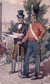 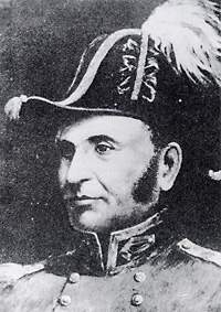 |
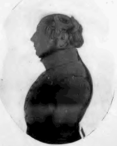
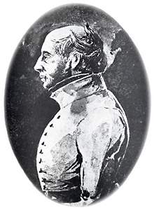
Which image is the real John By?
The only known authentic image of John By is the silhouette on the upper left, presented to several of his favourite contractors. It fits William Lett's description of By as being "portly." (see poem below). The image on the right is a face put on that original silhouette by an unknown artist. The two images below are artists' imaginary renderings, the one of the left, by C.W. Jefferys, looks nothing like Colonel By, the one of the right, an idealized rather than authentic image of By. Upper Left = Colonel John By by unknown, c.1831, Library and Archives Canada. Upper Right = Lieut.-Col. John By, Royal Engineers, Founder of Bytown by unknown, c. 1891, Library and Archives Canada, C-28531. Lower left = Colonel By Watching the Building of the Rideau Canal, 1826 by C.W. Jefferys, c.1930, Library and Archives Canada, C-073703. Lower right = Colonel John By, Royal Engineers; 1830 by 'C.K.', n.d., Library and Archives Canada.
The portly Colonel I behold
Plainly as in the days of old,
Conjured before me at this hour
By memory’s undying power ;
Seated upon his great black steed
Of stately form and noble breed.
A man who knew not how to flinch—
A British soldier every inch.
Courteous alike to low and high
A gentleman was Colonel By ! |
From "Recollections of Bytown and its Old Inhabitants" by William Pittman Lett, 1874.
|
By and his family departed London aboard the bark Endeavour on April 23, 1826 and landed at Quebec City on May 30. On June 1, Colonel By and his family; his wife Esther By, their 2 children, 7-year old Esther and 5-year old Harriet, and a friend, took the steamboat New Swiftsure from Quebec City to Montreal. Along with By were 2 man servants and 2 horses (military officers often travelled with their horses). The Bys took up residence on the McTavish Estate.
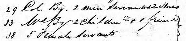 |
| This shows part of the ship's manifest of cabin passengers on the New Swiftsure, showing Colonel By as well as his wife Esther By and their two children, and a friend. It's unclear if the 5 female servants were part of the By group, but the brackets indicates they likely were. Most well to do families of that era had multiple servants. From the McGill University Archives via Ancestry. |
On July 13, 1826, in a letter written by By in Montreal to General Mann, about the military defenses of Canada, By put a cost of building the Rideau Canal at £400,000, far higher than Smyth’s number. While not directly part of the story of the founding of Ottawa, it is a key piece of the story about why Colonel By never got the recognition he deserved. See the story “Bye By” in Tales of the Rideau for all those details.
On September 7, 1826, the Commanding Royal Engineer in Canada, Colonel Durnford, received specific instructions for By to proceed with the building of the Rideau Canal. In mid-September, Colonel By travelled up the Ottawa River to Wright's Town (Hull), arriving there on September 21.
Wright’s Town was a well established village founded by Philemon Wright in 1801. By 1826, the village and farms in the surrounding area had a population of about 800. By comparison, in Upper Canada, Kingston was the largest community with a population of about 2,800 with York (Toronto) next with about 1,700 people.
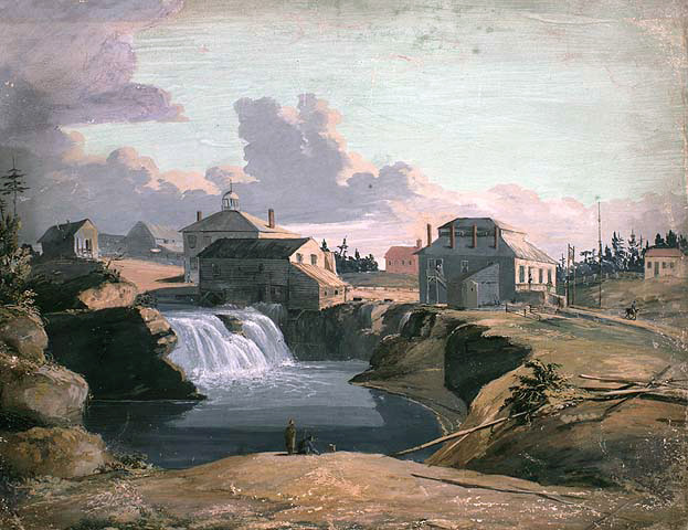 |
Wrights Town in 1823
This 1823 painting shows part of Wrights Town. Founded by Philemon Wright in 1801 it was a well established village by 1826. A sawmill and grist (flour) mill sit beside the waterfall. To the right is a foundry. Behind the mill, the building with a cupola is the tavern referenced in title. But it is a little unclear since a c.1824 map by John Burrows identifies this building as the new stone store. A building behind it (not in view in the painting) is identified as the new tavern. But it is possible that the store was also a tavern."A View of the Mill and Tavern of Philemon Wright at the Chaudière Falls, Hull on the Ottawa River, Lower Canada" by Captain Henry DuVernet, 1823. Library and Archives Canada, |
By was accompanied by several men including Lt. Henry Pooley R.E. and contractor Thomas McKay. In the following days, many others would arrive in Wright’s Town, including Colonel By’s wife Esther, Lord and Lady Dalhousie (Dalhousie was Governor-in-Chief of British North America), Colonel Durnford (head of Ordnance) with several other officers. Several of By's staff, including Thomas Burrowes and John Mactaggart, also arrived.
It's a little unclear how exactly they travelled from Montreal. The image "First Camp at Bytown" shows canoes with voyageurs. They were possibly supplied by the Hudson Bay Company. For instance, in the spring of 1827 we see surveyor John Burrows asking George Simpson, the head of the Hudson Bay Company for "two Birch Canoes with five men in each" to use for their first on-water survey of the Rideau Route.
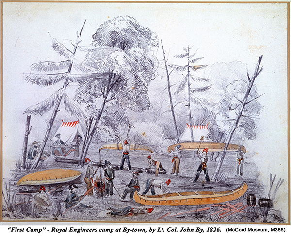 |
| Colonel By’s first camp on his arrival near Rideau Falls. The canoes in this image appear to be canots léger (5 m/16 ft long), designed for fast travel. The men in the peaked caps are French-Canadian voyageurs. The canoes were likely Algonquin made, using their advanced birch bark canoe building skills. “First Camp, By-Town”, Lt. Col. John By, 1826. McCord Museum. M386. |
Water travel on the Ottawa River was impeded by the Long Sault Rapids. This was a set of rapids that extended for 21 km from Grenville/Hawkesbury to Carillon. Three portages (Carillon, Chute-à-Blondeau and Grenville) were used to bypass the worst sections of rapids. It was at these spots that canals were being built. The Grenville Canal, started in 1819, would not be completed until 1833. The canals at Carillon and Chute-à-Blondeau would not be completed until 1834.
Water travel, including by batteaux, was possible in 1826. By that time, some of the worst sections of rapids had already been cleared of boulders to facilitate the passage of batteaux, durham boats, and other water craft. There was even a canal with small lock built in 1818 by a local settler at Pointe-Fortune.
There also was a regular stage coach service from Montreal to Grenville. It took 2 days over rough roads. It left downtown Montreal and crossed to the north shore at Saint-Eustache. It then travelled to St. Andrews East and on to Grenville. Grenville was just upstream of the Long Sault Rapids and it was clear sailing from there to Wright's Town.
From Grenville you could take the steamboat Union which was running a regular weekly trip to Wright's Town, or use other water craft. John Mactaggart appears to have taken the steamboat Union on his way to Wright's Town, so he may have taken the stage coach from Montreal. The Union, which entered service in 1820, was 125 feet long on the deck, by 25 feet beam, and powered by a 28 horse power engine. The landing for steamboats and other water craft near Wright's Town was on the north shore, directly opposite from Sleigh Bay (Entrance Valley) on the south shore.
The Dalhousies travelled by batteau. One of their stops was at Marston's Landing (Richmond) on their way to/from Wright's Town. Others would have come by batteau, durham boat, canoe or by steamboat (Union, from Grenville only). The fastest way to travel would have been in canoes paddled by voyageurs. This is most likely how Colonel By and Pooley travelled to Wright's Town. They appear to have used canot léger (lightweight canoes), designed for fast travel. They were in use at this time by the Hudson Bay company to quickly transport important personnel, mail and other things that needed fast transportation.
After his arrival, Colonel By and Lt. Pooley examined the potential starting points for the canal starting with Governor Bay, which was the starting location in Samuel Clowes’ survey which had taken the canal all the way down the Rideau River to the Ottawa River. Colonel By had been ordered to follow the line of the canal as established by Samuel Clowes. But he also had discretion to choose the best route from an engineering and military point of view.
While there is a whole story around the potential use of Richmond Landing and taking the canal through Dow’s Great Swamp, this doesn’t appear to have been considered by Colonel By. He chose the upper (upstream) valley that he investigated, known today as Entrance Valley. One of the reasons he chose it was due to its military defensive location with a hill, today’s Parliament Hill overlooking it.
The valley also had a beaver meadow at the head of the valley which By noted was an ideal location for a lay-by (basin) and canal water reservoir. It was fed by a stream coming off Parliament Hill which continued into what was to become Lower Town. The beaver meadow was, as the name suggests, created by beaver dams on that stream. Thomas McKay, who was a masonry contractor who had helped build the Lachine canal in Montreal, found good quarry stone on either side of the valley.
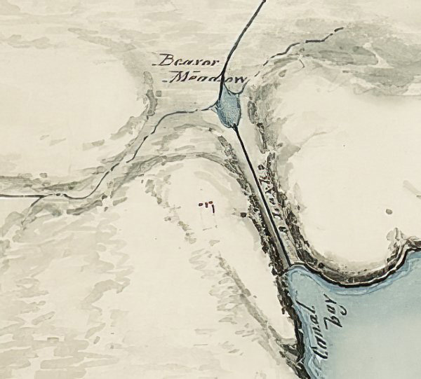
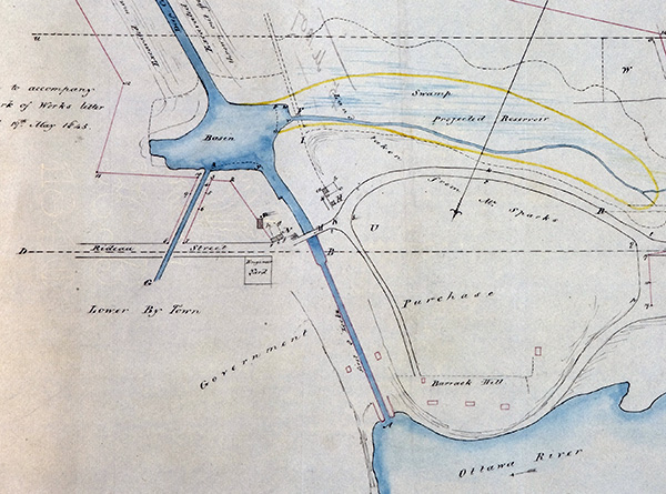
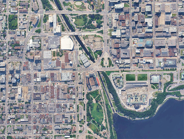 |
Top - an 1827 map, looking southeast, showing the beaver meadow at the head of Entrance Valley. It was fed by a stream coming in from the right (base of Parliament Hill) and then exited the beaver meadow to flow to the Rideau River. The line running up from the Beaver Meadow is the first proposed route of the canal. Once the area was explored, that plan was changed to running the Deep Cut to the Natural Gully.
Middle: an 1845 map showing the Beaver Meadow transformed into the Canal Basin, with the drain, controlled by a small set of locks, running through Lower Town. The area of the stream feeding the basin is a swamp, proposed at that time to be converted into a canal reservoir. That was never done.
Bottom: A satellite view of the area today. The basin is filled in, now occupied by the National Gallery of Canada to the west and the Roger's Convention Centre to the east. Barrack Hill is now Parliament Hill. Top: “Sketch of the route of the Rideau Canal from Canal Bay in the Ottawa to the foot of the Black rapids", by Henry Pooley, c.1827, Library and Archives Canada, Microfiche 97797. Middle: "Sketch of Bytown to accompany the clerk of works letter dated May 19, 1845." by unknown, The National Archives of the UK, MR1-1925. Bottom: Google Earth 2024. |
On Monday, September 25, 1826, Colonel By, Lord Dahousie and several others, including Lt. Pooley and Colonel Durnford, did an investigation of Entrance Valley and the land above it all the way to the Rideau River. As Dalhousie described it in his diary, “a most pleasant and interesting walk thro’ the woods …” They stopped at the cabin of settler Lewis Williams for a bite to eat before returning to Entrance Valley and then back to Wright’s Town.
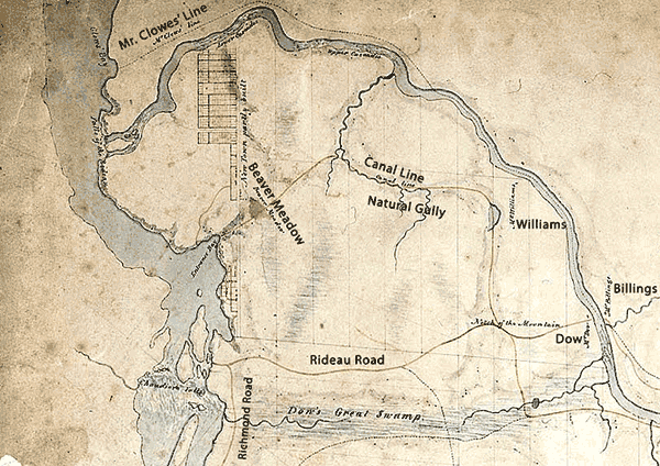
This area, between the Ottawa River and the Rideau River was very sparsely settled, with a just a few settlers such as Nicholas Sparks, Lewis Williams, Abraham Dow and Braddish Billings. There were a few early roads, including a road connecting Richmond Landing with the Rideau River to where Dow and Billings were living. There was also a road on the east side of the Rideau River, going from Governor’s Bay to where Captain Andrew Wilson had settled on the Rideau River in 1819, south of today’s Mooney’s Bay. There was the Richmond Road, leading to Richmond and Perth. There was also a road/trail along the high lands above the Ottawa River from Richmond Landing to Rideau Falls.
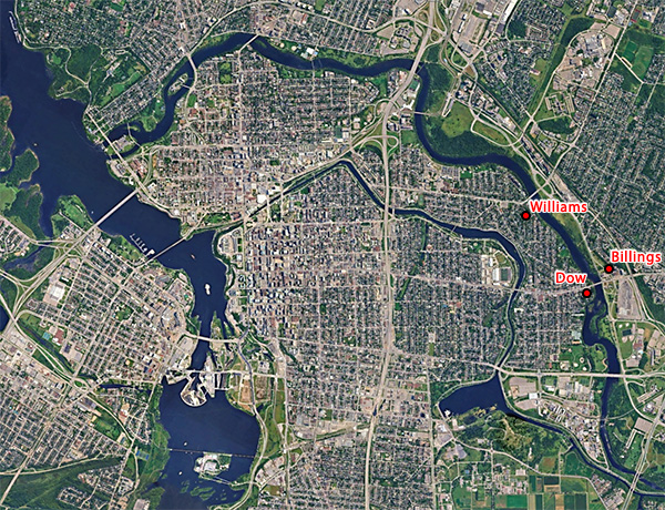 |
Top: An annotated section (crop) of an 1827 map by Colonel By. In it we can see the area explored on September 25, 1826, from Entrance Valley to the Rideau River near Lewis William's cabin. William's cabin is a bit mispositioned, he was closer to the river than shown on this map.
Bottom: That same area today. It's changed a bit over the last 200 years.
Top: Section from “Sketch shewing the proposed line of the Rideau Canal from the River Ottawa to the Head of Long Island with the positions of the various works required to complete the navigation for 44 miles carrying the level of the canal 144 feet above the level of the Ottawa. John By, Lt. Colonel Roy'l. Engrs. Com'g. Rideau Canal, 7th July 1827”. Library and Archives Canada, NMC16813. Bottom, image from Google Earth, Imagery July 2024. |
It was likely during dinner that evening of September 25 that By proposed building a series of bridges to span the Ottawa River just below Chaudière Falls. One reason was to create a supply line between the resources on the Lower Canada (Quebec) side and the canal project on the Upper Canada (Ontario) side. Philemon Wright had a well-established settlement with farming, timbering and quarrying on that side of the river, resources that would be useful for the Rideau Canal project.
 |
| This is part of an 1827 drawing showing three styles of bridge used to span the Ottawa River. This section of the drawing shows the four on the Quebec side: a Timber Truss-Arch Bridge on the left, a Timber Trestle Post-and-Beam Bridge in the middle and two masonry arch bridges. It was a mammoth feat of engineering for the era. They were also expensive. In May 1828, Colonel By totaled up the cost to be £4,740. The bridges, linking Lower Canada with Upper Canada, known as the Union Bridge, opened for traffic in September 1828. The timber truss arch bridge section shown above collapsed on May 18, 1836 (nobody was on it). Section from “Plan & elevation of bridges at the Falls of Chaudière, erected in 1827 under the superintendence of Lt. Coln. John By, Commanding Royal Engineer, Rideau Canal.", by John Burrows, 1827, Library and Archives Canada. |
In a letter dated September 26, 1826, Dalhousie approved By's recommendations for a bridge and provided information, including a map, that showed that the government already owned the land through which start of the canal was to run. He also recommended that By survey in lots for a town in that location. This was the founding of Bytown, later to be known as Ottawa.
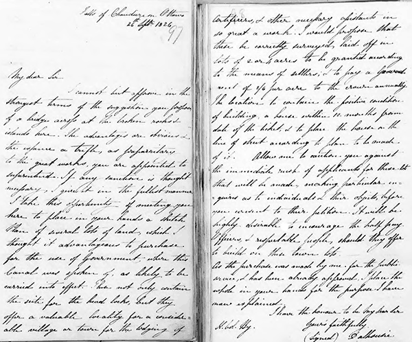
(from Library and Archives Canada, RG8-I, Volume number: 42)
Falls of Chaudiere on Ottawa
26th Sept 1826
My dear Sir
I cannot but approve in the strongest terms of the suggestion you propose of a bridge across at the broken rocks & islands here. The advantages are obvious & the expense a trifle, as preparatory to the great works you are appointed to superintend. If any sanction is thought necessary, I give it in the fullest manner.
I take this opportunity of meeting you here to place in your hands a sketch plan of several lots of land which I thought it advantageous to purchase for the use of Government, where the Canal was spoken of as likely to be carried into effect. These not only contain the site for the head locks, but they offer a valuable locality for a considerable village or town for the lodging of Artificers, & other necessary assistants in so great a work. I would propose that these be correctly surveyed, laid off in lots of 2 or 4 acres to be granted according to the means of settlers, & to pay a Ground-rent of 2/6 per acre to the Crown annually. The location to contain the positive condition of building a house within 12 months from date of the ticket, & to place the house on the line of street according to plan to be made of it. Allow me to caution you against the immediate rush of applicants for these lots that will be made, making particular enquires as to individuals & their objects, before you consent to their petition. It will be highly desirable to encourage the half pay Officers, & respectable people, should they offer to build on these town lots.
As the purchase was made by me for the public service, & has been already approved, I place the whole in your hands for the purpose I have now explained.
I have the honour to be My dear Sir
Yours faithfully
(Signed) Dalhousie
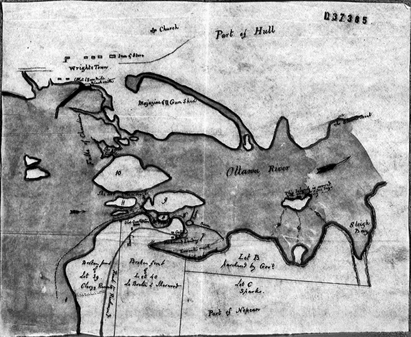
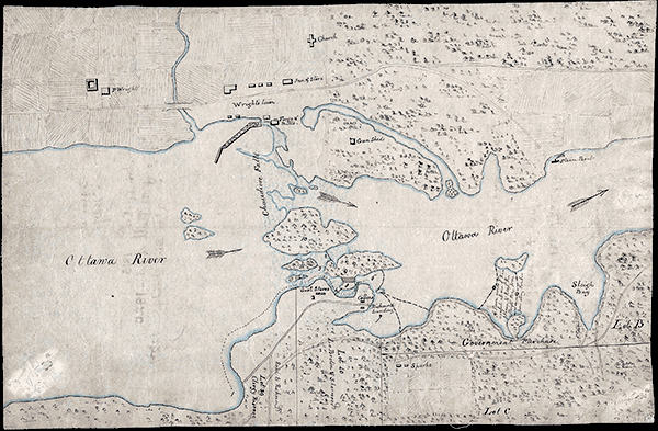 |
This is assumed to be the map Dalhousie handed to Colonel By showing the government land. The top is the February 1825 original, the bottom a later cleaned up copy. The map was done by Major G.A. Eliot of the 68th regiment. This map (top map) was included in a letter he wrote dated February 15, 1825, to Sir Peregrin Maitland, Lieutenant Governor of the Province of Upper Canada. In that letter Eliot complained of the difficulty in creating it. He noted "that part of the Township having been several times surveyed, & no two agreeing ; making it impossible to ascertain where any lot was bounded".
This was just the beginning of land ascquisition issues. In February 1827, the Rideau Canal Act was passed which allowed Colonel By to acquire land for canal purposes, but it remained time consuming and expensive, siginificantly adding to the costs of building the canal. Top: Upper Canada Sundries, Library and Archives Canada, RG 5, A 1, Vol. 70. Bottom “Sketch of both banks of the Ottawa River and the Chaudiere Falls, from P. Wright's house to the Steamboat Ferry on the North side & showing Gov't Stores, Richmond Landing and the road, the Clergy Reserve, the Lebreton and Sherwood property, the Government purchase and Spark's House on the South side." by G.A. Eliot, 1825, Library and Archives Canada, ID 4138620. |
By laid out lots for Upper Town and Lower Town and by the spring of 1827, with people flocking to the area to obtain work on the construction of the Rideau Canal, a community quickly grew. Originally known as By’s Town, that morphed into the name Bytown. It earned a rough reputation, particularly in the years after the completion of the Rideau Canal, with conflicts between French-Canadian and Irish timbermen, later known as the Shiner Wars.
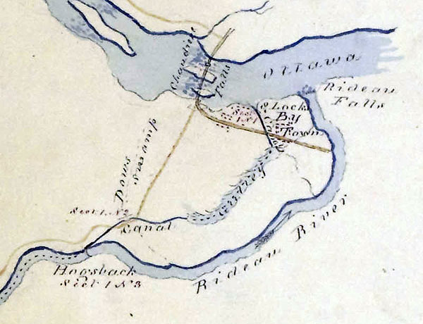 |
| On this 1828 map, By Town is labelled as well as the final route of the canal. Telling is the representation of the Natural Gully, part of Colonel By's slackwater system. Only 62% of the canal between the Ottawa Locks and Hogs Back are man made canal cuts, the other 38% are flooded natural features created by dams (Natural Gully and Dow's Lake). By had to adapt to local conditions, working with what nature provided rather than against it. The Rideau Canal is today internationally known as a masterful example of 19th century adaptive engineering. In the Ottawa area, there are many examples of this, including his use of the Natural Gully to save a huge amount of excavation. He did have to excavate a channel from the Basin to the Natural Gully. Known as the Deep Cut, after encoutering excavation difficulties, he adapted by raising the height of Ottawa Lock 8 by 2 feet in order to save 2 feet of excavation. Other examples in this area included changing the original concept of a "mounded aquaduct" over Dow's Great Swamp to instead doing two dams, creating Dows Lake. He moved two of his three planned locks at Hogs Back to Hartwell's to take advantage of topography to save excavation and the list goes on. For a complete lock by lock description of original plans and changes that had to be made, see my book "A History of the Rideau Lockstations" which explains these in detail: "A History of the Rideau Lockstations" Section from "Sketch of the line of the Rideau Canal from Bytown to Kingston (no. 3).", 1828, Earl of Dalhousie fonds, National Archives of Scotland. GD45/3/9. |
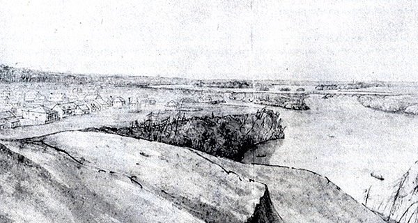 |
| Bytown in 1828. This sketch shows some of the buildings in Bytown. In the background the bridges spanning the Ottawa River at Chaudière Falls can be seen Section from "Bytown, Upper Canada in 1828" by Lt. Edward Frome, Frome Collection, The Royal Commonwealth Society. |
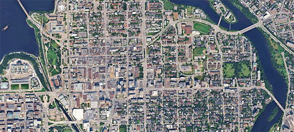 |
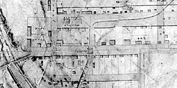
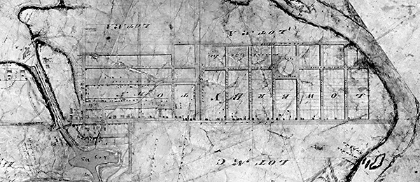
| Top/Middle: An 1831 map of Bytown. This is Lower Town Ottawa at the end of lock construction. In the top image you can see the details. On the left are the head of the locks and Sappers Bridge. Beside it is the Engineers and Artificers Work Yard (carpentry, blacksmithing). Beside it is the market, today's Byward Market. Much of the housing is concentrated in this area and also strung out along Rideau Street all the way to the Rideau River. The bridge on Rideau Street visible in the top map crosses the drain from the basin which ran through Lower Town. The circle visible in the middle image in center Lower Bytown is Anglesea Square (renamed Jules Morin Park in 1989).
Top/middle - sections from "Plan of the Rideau River & the Rideau Canal from the Ottawa River to the Black Rapids with Upper and Lower Bt Town, Lt. Coln. By Commanding Royal Engineer", 1831, Library and Archives Canada NMC17422. Bottom Google Earth view, 2024. |
The rough reputation of Bytown is the main reason for the name change to Ottawa, to shed its rough frontier past as it headed towards a better civic future, including the idea that it could become Canada’s capital. And so, on January 1, 1855, the name was changed from Bytown to Ottawa.
This was also a time when control of the Rideau Canal was being handed over from the British military to civilian government (Province of Upper Canada). In May of 1855, Parliament passed an enabling act to transfer the military canals (Rideau, Ottawa) to civilian authority. This was subsequently done via an Order In Council in January 1856 and ratified, via the Ordnance Land Transfers Act, in June 1856. Those canals were placed under the control of the Department of Public Works in March, 1857.
On December 31, 1857, Queen Victoria chose Ottawa as the capital of the Province of Canada. At that time, various cities; Montreal, Quebec, Kingston and Toronto were lobbying to be the capital. Queen Victoria chose Ottawa due its location away from the American border and because it was on the border of Upper and Lower Canada (Ontario & Quebec). This was later reaffirmed during Canada’s confederation in 1867, with Ottawa as the capital of the Dominion of Canada.
-Ken W. Watson
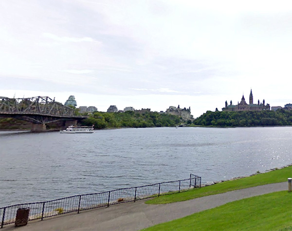 |
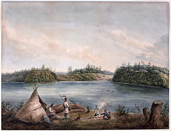
Top: this beautiful painting was done by Lt. Henry Pooley, R.E., in 1833. He was on the north shore of the Ottawa River, near the present day Canadian Museum of History, about 100 m south of the Monument to the Algonquin Chief Tessouat near the Canadian Museum of History. It tells a story of changing times with the indigenous family in the foreground and the Rideau Canal in the background.
During the building of the canal, relations with indigenous peoples were cordial. They continued their hunter/gathering ways in the Rideau Corridor while the canal was being built. That way of life was already in decline in Ontario as forests were being converted into farmland by settlers. If you look above at the 1825 Eliot map, you can see the example of Wright's Town, where a very large area is now cleared of trees and is being farmed, mostly for wheat. The same was happening on the Rideau, with large areas in townships such as Bastard, Kitley, Wolford and Oxford converted from forest to farmland by 1826. There were supplying wheat to well established grist mills in places such as Merrickville, Delta, Brockville, Gananoque and Kingston.
Lockage records show the Rideau Canal being used by indigenous paddlers until the mid-1800s. By that time most of the forests had been cut down, to the point that the Rideau Canal needed to implement the use of reservoir lakes, with water retention in forested uplands now gone. But that's another story.
Bottom: A similar view of Ottawa today. The entrance to the Rideau Canal, the magnificent flight of 8 locks, is now dwarfed between Parliament Hill and the Chateau Laurier Hotel. Other features in the Pooley painting, such as Colonel By's house, visible in the centre of the painting, are now gone.
"Entrance of the Rideau Canal, Ottawa River, Canada" by Henry Pooley, 1833. National Gallery of Canada. Bottom, Google Streetview, 2026. |
|

