Your location: Rideau Canal Home Page > Ecology of the Rideau > Rideau Ecology
 Rideau Ecology - A Brief Synopsis
by Ken W. Watson
| The photos in this article, unless otherwise credited, are by Ken W. Watson
|
 The Rideau Canal is a waterway located in Ontario, Canada that extends from the City of Kingston in the south to City of Ottawa in the north, a distance of 202 km (125 miles). From Lake Ontario at Kingston the canal rises 50.6 metres (166.2 ft.) to the summit of Upper Rideau Lake and then descends 83.8 metres (275 ft.) to the Ottawa River at Ottawa (see the Profile of the Rideau Waterway). Built in 1826-1831, it uses 45 locks in 24 lockstations to allow vessels draughting up to 5 feet to navigate the route. In the late 1880s two additional locks were built to connect the Town of Perth, via the Tay River, to the Rideau Canal. The Rideau Canal is a waterway located in Ontario, Canada that extends from the City of Kingston in the south to City of Ottawa in the north, a distance of 202 km (125 miles). From Lake Ontario at Kingston the canal rises 50.6 metres (166.2 ft.) to the summit of Upper Rideau Lake and then descends 83.8 metres (275 ft.) to the Ottawa River at Ottawa (see the Profile of the Rideau Waterway). Built in 1826-1831, it uses 45 locks in 24 lockstations to allow vessels draughting up to 5 feet to navigate the route. In the late 1880s two additional locks were built to connect the Town of Perth, via the Tay River, to the Rideau Canal.
Only about 10 percent of the waterway is directly man-made with locks, canal cuts and channel straightening. The locks and cuts connect a series of lakes and rivers to form the navigation way. Some of the lakes along the route pre-date the canal, others were formed by flooding when river sections were dammed. The present day landscapes along the Rideau are varied, ranging from natural to rural to urban, often in the space of just a few kilometres.
The arched profile shape of the Rideau Canal is due to the fact that it crosses a major watershed divide, with the Rideau River watershed to the north, flowing to the Ottawa River and the Cataraqui River and Gananoque River watersheds to the south, flowing to Lake Ontario and to the St. Lawrence River.
Geography of the Rideau Canal Waterway
The geography of the Rideau has been shaped by the underlying geology of the region. This has been described in the article "The Shaping of the Rideau." The following is a brief geographic tour of the Rideau, from south to north.
Kingston, at the southernmost end of the Rideau Waterway sits on a limestone plain. The southern end of the Rideau Canal is Kingston Bay, the mouth of the Cataraqui River. This leads into the Cataraqui Marsh, an extensive wetland that abuts against the southernmost extension of the Frontenac Axis on the Rideau. This is represented by a dramatic outcropping of shield rocks at Kingston Mills, the site of the former Cataraqui Falls, the final drop of the Cataraqui River on its way to Lake Ontario.
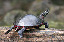
A Midland Painted Turtle |
Colonel By Lake and the River Styx - these are man-made lakes created by the 7.6 to 8.5 m (25 to 28 ft.) of flooding by the locks and dam at Kingston Mills and so represents a "new" (post-1832) ecosystem. In the pre-canal era a small Cataraqui River wound sinuously through a mixture of forest and swampy land that now forms the floor of Colonel By Lake. The area under River Styx was forested land with the Cataraqui River running through it. Much of River Styx sits on younger sandstone which lies uncomformably on top of the much older Precambrian shield rocks
Cataraqui River - the present day Cataraqui between River Styx and Cranberry Lake is much different today than it was in the pre-canal era. Much of the channel in this area was straightened to cut off the meanders of the original Cataraqui River. The water flow is higher than in the pre-canal, pre mill dam era with the addition of the western Gananoque River watershed (Newboro, Clear, Indian, Opinicon & Sand Lakes) to the Cataraqui watershed. The original rapids in this section were bypassed with canal cuts. The headwaters of the pre-canal Cataraqui River were Loughborough and Dog lakes. Dog Lake has seen extensive flooding (the southern section of Dog Lake is man-made) as a result of the dam and locks at Upper Brewers.
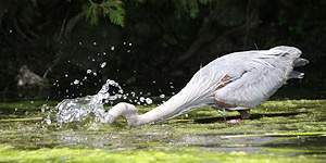
A Blue Heron grabs a snack |
Cranberry Lake and Little Cranberry Lake – these are man-made lakes originally created by mill dams at Morton and the Round Tail and later by canal dams at Morton and Upper Brewers. The water level at Upper Brewers was raised by about 5.5 m (18 ft.) flooding the area all the way to Jones Falls. The area under Cranberry and Little Cranberry used to a large flood marsh which separated the Cataraqui and Gananoque watersheds (there was no regular water flow through the marsh). Much of Cranberry Lake and all of Little Cranberry is underlain by Precambrian crystalline limestone (marble).
Whitefish Lake – another man-made lake, in the pre-canal era the White Fish River, the western feeder of the Gananoque River flowed from Sand Lake though Morton to what is today Lower Beverley Lake. The area now occupied by Whitefish Lake was a forest. Mill dams built at Morton and the Round Tail in the early 1800s flooded this area creating the “Drowned Land.” Later the canal dams at Morton and Upper Brewer raised the water even further creating today’s Whitefish Lake. Whitefish Lake is underlain by Precambrian crystalline limestone. The spectacular Rock Dunder and Dunders Mate in Morton Bay are the westernmost exposure of the Lyndhurst granite pluton.
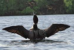
A Loon stretching |
Sand, Opinicon, Indian, Clear and Newboro Lakes – these are all natural lakes which were raised to some degree by the building of locks at dams. Sand Lake was raised by about 2.4 m (8 ft.), Opinicon by about 3.3 m (11 ft.), Indian by about 2.4 m (8 ft.) and Clear and Newboro lakes by about 1.8 m (6.0 ft.). At the foot of Sand Lake used to be the Jones Falls Rapids which dropped almost 18 m (60 ft.) over the distance of a mile (1.6 km). These rapids were the head of the White Fish River that flowed to the Gananoque River. These rapids were drowned by the building of the Jones Falls dam and locks. Similarly Davis’ rapids (between Sand and Opinicon lakes) and Chaffey’s rapids (between Opinicon and Indian lakes) were also drowned. Mosquito Lake is a man-made lake, it was formerly Mosquito Creek which drained Newboro and Clear lakes into Indian Lake. Sand, Opinicon and Indian lakes are underlain for the most part by Precambrian crystalline limestone while most of Newboro and Clear lakes are underlain by Precambrian granitic gneiss.
Newboro Isthmus – this is the present day watershed divide between the Rideau River and Cataraqui River watersheds. In the pre-canal era it was the divide between the Rideau River and Gananoque River watersheds.
Upper, Big and Lower Rideau lakes – these are all natural lakes raised to some degree by the building of locks and dams. In the pre-canal era there was one Rideau Lake. Big and Lower Rideau lakes were raised about 1.5 m (5 ft.) with the building of the lock and dam at Poonamalie. Upper Rideau Lake is about 2.4 m (8 ft.) above the level of the original Rideau Lake, flooded by the dam and lock at Narrows. The northern boundary of these lakes follows the Rideau Lake Fault. On the northern side of these lakes are several granite plutons which provide topographic relief (i.e. Foley Mountain) in that area. The southern side of Upper Rideau and parts of Big Rideau are underlain by flat lying Ordovician sandstone. The islands of Big Rideau and the northeast side are underlain by Precambrian crystalline limestone. The northern part of Big Rideau marks the northeastern boundary of the Frontenac Axis. The northern end of Big Rideau and all of Lower Rideau Lake are underlain by Ordovician sandstones. Rideau Ferry marks the southern boundary of the former Champlain Sea, a brackish sea formed at the end of the last ice age than extended north, past Ottawa.
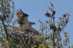
An Osprey in its nest |
Rideau River – the Rideau River from its head at the foot of Lower Rideau Lake to Ottawa is today slower, deeper and wider than it was in the pre-canal era. Canal dams have flooded all sections of the river, flooding the many rapids that used to exist along the river’s route. In most cases the flooding is from .5 to 3.6 m (2 to 12 ft.). The two exceptions to this are the dams at Long Island and Hogs Back. At Long Island, the river was raised 7.6 to 8.2 m (25 to 27 ft.), which flooded the Rideau River almost to Burritts Rapids, and at Hogs Back the river was raised 12.5 m (41 ft.) which flooded the river all the way to Black Rapids. Of note, the present day Hogs Back Falls is actually an man-made excavated weir channel, the original rapids at Hogs Back only fell about 1.8 m (6 ft.) over a distance of 600 m (2000 ft.) and could be run by canoe.
The Rideau River is underlain for the most part by Ordovician dolomites and limestones. Glacial till has been deposited on top of these rocks in many areas. Towards Ottawa are clay deposits from the sediments of the Champlain Sea (i.e. Leda clay).
Flora and Fauna of the Rideau Canal Waterway
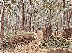
French Canadian Axeman |
Although the Rideau Canal has been flooded in virtually every section, it has had almost two centuries to settle into a new natural equilibrium. The water levels along the waterway have not changed appreciably since 1832. The greatest ecosystem change was not the flooding of the Rideau but rather human settlement and the conversion of forest to farmland. By the late 1800s almost all the forests along the Rideau had been removed, farming was even taking place on the less than ideal shield rock region (now cottage country). This had a dramatic impact on the watershed. Water retention in the system dropped dramatically with the removal of the forests and by the late 1800s a system of reservoir lakes had to be put in place to maintain the Rideau at proper navigation levels.
In the 20th century, farming of the poor lands on the shield rocks declined. Lumbering has also declined and in many areas the forests are returning. Farming and lumbering in these areas bordering the Rideau have been replaced by cottage and summer home development. All these changes have resulted in today’s ecosystem, a mix of natural, rural, cottage and urban environments that abut the Rideau Canal.
A Paradise for Herons and Woodpeckers
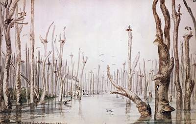
painting titled "The Drowned Land - Rideau Canal 4 August 1844" by Major George Seton, Library and Archives Canada. |
The initial flooding of the Rideau caused some immediate changes. Animals that could take advantage of these changes prospered. An 1840s painting of a flooded forest shows a large population of blue herons and pileated woodpeckers, two birds that flourished with the large amounts of standing dead trees. By the late 1800s the central lakes (Sand, Opinicon, Indian, Clear & Newboro) became renown in North America for their spectacular largemouth bass – a species of fish that thrived in the flooded shoreline environment. It is unknown if the overall amount of marshland increased or decreased with the building of the Rideau Canal. While many marshes were flooded, new marshes were created. Migratory birds that use the mashes of the Rideau today likely used the Rideau in the pre-canal era.
Lakes – the lakes along the Rideau are varied, some pre-date the canal and some were created by the flooding of the canal. They range in depth from 3 m to over 90 m (10 ft. to 300 ft.). Most of the lakes are Mesothrophic (moderately enriched with nutrients, phosphorus levels of 10 to 20 ug/L) with some of the
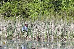
A scientist from the Queen's University Biology Station on Opinicon Lake |
shallower southern man-made lakes verging on Eutrophic (highly enriched, phosphorus > 20 ug/L). These lakes abound with many species of fish. Lake Trout can be found in the deep (> 30 m /100 ft.) lakes (Big Rideau, Dog Lake) while warm water fish (bass, pike, sunfish, crappie) can be found in all of the lakes. Aquatic vegetation is present in all the shallow (< 3.6 m / 12 ft.) and wind/current sheltered areas of the lakes. This vegetation in many areas is dominated by Eurasian Milfoil, an “invasive species” introduced to the Rideau in the 1960s. The shoreline environment is home to many species of frogs, turtles, snakes and animals such as raccoons. Birds such as loons, herons and osprey are common. The lakes and rivers of the Rideau are also now home to large populations of zebra mussels (particularly since 2000) that have had the effect of increasing water clarity and altering the abundance and type of aquatic vegetation. Aquatic vegetation is now found in deeper water (since sunlight can now penetrate deeper) and species of algae such as spirogyra and cladophora are thriving in much greater numbers as the zebra mussels filter out their competition.
A cruiser in the channel beside "The Swale" wetland near Smiths Falls |
Rivers – the most extensive river environment is the Rideau River. The river borders farmland and urban environments for much of its distance and as a consequence is highly enriched in summer with phosphorus (up to over 40 ug/L). The river supports a large population of animals and fish. Warm water species of fish thrive including sunfish, bass, carp, catfish, crappie, pike, perch, walleye and muskellunge. There are many varieties of aquatic plants including tape grass, coontail, bulrushes, milfoil, pondweed, bladderwort, frogbit, duckweed, and water lily. The river is host of thousands of migratory birds in spring and falls, one of the most important migratory bird staging areas in Eastern Ontario. Some species such as the mallard duck and blue heron make the river their summer home. The river supports a large frog population although increasing urban development is decreasing this population. Snakes and turtles also abound although the population of these is also decreasing with the new urban developments taking place along the river.
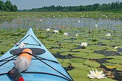
LILY PADdling |
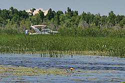
Rideau marshlands – the Rideau is home to several wetlands, ideal habitat for marsh loving creatures. These marshes are dominated by cattails and waterlilies. They also include many other plant species such as sedge, phragmites, duckweed and frogbit. These marshes are home to birds such as the blue heron, redwing blackbird, marsh wren and american bittern. Dragonflies and damselflies dart about in search of mosquitoes. Muskrats are plentiful, building dens of cattails and bulrushes. Frogs abound, particularly bullfrogs and green frogs. Turtles too are common including the large snapping turtle and smaller painted turtle.
Bogs and Swamps – these border the waterway in some areas, particularly along the Rideau River section. A bog is an area of acidic water, usually in a depression in which sphagnum moss thrives, slowly converting to peat. Hummocks formed by the mosses provide anchoring points for trees such as black spruce, tamarack and alder. Swamps generally have fresher water and are home to cedar trees (cedar swamps) or black ash and silver maple (hardwood swamps). These bogs and swamps are home to many species of frogs.
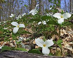
Trilliums cover the forest floor |
Forests – most of the forests along the Rideau are deciduous forests dominated by trees such as maple, oak, birch, basswood, poplar and ash. On rockier exposures, especially in the southern shield rocks area, conifers such as pine, spruce, hemlock and cedar are abundant. Since virtually all of the Rideau was lumbered at some point in time these forests represent various levels of maturity. Mature forests tend to be dominated by a few species of trees (i.e. maple and oak) that have shaded out their competition. Forest are home to many other types of fauna including many species of mushrooms, lichens and flowers such as trilliums and bloodroot. Many animals make the forests their home including squirrels, chipmunks, fox, marten, porcupines, racoons, woodpeckers (hairy, downy, pileated), grouse, and much more. Deer can also be found, preferring forested areas in the vicinity of open fields. Turkeys have been reintroduced to the southern Rideau and are now abundant in forested areas near open fields.
Fields – most of the fields bordering the Rideau are either current, fallow or abandoned farmland. These are home to many bird species such as warblers, crows, meadowlarks and sparrows. On abandoned fields one of the first plants to appear is the milkweed, favoured by the monarch butterfly. Frogs abound in the forest/field margins including the leopard frog, chorus frog and american toad. Snakes can also be found, the most common being the garter snake.
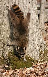
Some daylight foraging |
Cottage Lands – these represent a somewhat unique environment, usually a forested area with a certain amount of cleared land (houses, roads and yards). The shorelines in these areas have been partially to fully developed (retaining walls, docks, boathouses). Animals associated with this type of suburban environments predominate (squirrels, crows, raccoons) mixed with shoreline fauna such as turtles, frogs and snakes depending on how much of the shoreline has been left in a naturalized state.
Rural Lands – really part of “fields” there are many active farms along the Rideau mostly involved in the raising of beef and dairy cattle and farming crops such as hay, corn and soybeans. Some farms use maple forests associated with their farms to make maple syrup in the spring. Animals that can take advantage of these rural land environments (i.e. deer, crows, turkeys) thrive.
Urban Lands – these are complete man-made environments (lawns, pavement, buildings, manicured parks). The City of Kingston in the south doesn’t really abut onto the Rideau (just part of Kingston Bay). The few communities along the southern part of the route are small villages (i.e. Seeley’s Bay, Newboro, Westport, Portland). The largest community in this area is the Town of Smiths Falls that has maintained a compact development in the area of the canal. The most significant urban development is on the northern Rideau, from Manotick to Ottawa. Manotick is now a suburb of Ottawa and there is extensive development taking place in this area. Once into the Ottawa, a completely man-made and controlled environment surrounds the canal.
Conclusion
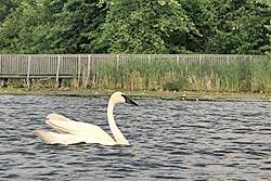
A swan swims by the viewing boardwalk of the Portland Wetland |
One of the nice features of the Rideau is that it is not a monochromatic environment, but rather a diverse blend of various types of ecologies. Most of these ecologies are not segregated, they often appear side by side. For instance, “The Swale,” a wetland, sits in the shadow of the urban environment of Smiths Falls. It’s not uncommon while boating on the Rideau to pass by a large summer home with manicured lawn and turn the corner into a bay with absolutely no cottage development.
Lt. Colonel John By, the architect of the Rideau Canal, made the fortunate decision to create a slackwater canal system, flooding rapids rather than bypassing them with canal cuts. In doing so he created many lake and marsh environments, home to hundreds of species of plants and animals. It is also fortunate that much of the canal passes through the shield rocks of the Frontenac Axis, land that is today best suited for cottage development rather than urban or farm development. Active lake associations and environmental education programs are helping reduce the impact of cottage development, allowing cottagers and the natural environment to co-exist.
 | |  |
Comments: send me email: Ken Watson
©1996- Ken W. Watson
|