Your location: Rideau Canal Home Page > Rideau Lockstations > Merrickville Locks 21-23
| Number of locks: 3 |
Total Lift: 7.4m ( 24.7 ft.) |
Lock Through Time: 45 min.* |
| Chart No: 1512 (Sheet 3) |
GPS:1 N 44° 55.000' W 75° 50.200' |
| Chart Sales: No |
Lockstation Tel: 613-269-4787 |
| Washrooms: Yes2 |
Drinking Water: Yes3 |
Day Use Docking: Yes |
| Overnight Mooring: Yes |
Docking4 Upstream: 145m/475' |
Docking4 Downstream: 37m/120' |
| Ice: No |
Power: Yes5 |
Boater Camping:6 Yes |
| Boat Launch: No |
Picnic Tables: Yes |
BBQ Grills: No |
| Parking: Limited |
Public Telephone: Yes7 |
Self Guided Trail: Yes |
| Hwy Access: beside Main St. |
Locks Connect: Rideau River to Rideau River |
| Civic Address: 111A Main Street East, Merrickville-Wolford, Ontario |
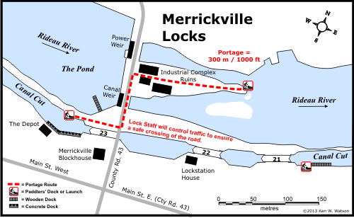
| Special Notes: To ensure passage, boaters must arrive at least 1.5 hours prior to closing. Swing bridge at upper lock with clearance of 2.9m (9.5 ft). Swings on demand. Boaters approaching from the upstream side who wish to overnight should head left (north) at buoy NM2 to the greyline docking in the basin rather than heading to the blueline docking at the upper lock. Space is often limited at the blueline docking and the channel is too narrow for larger boats to turn around.
|
| Of Interest: The Merrickville locks are located at the earliest mill site on the Rideau River, that of Roger Stevens, who built a mill here in about 1790. But it was William Mirick, who, a couple of years later, took over the mill and established a community which was thriving by the time of canal construction. The locks bypassed the mills, leaving them intact, allowing Mirick to continue his business. They are spaced out, three detached locks, taking advantage of the natural topography. The largest blockhouse on the Rideau, built here in 1832, is now operated as a museum. Merrickville is known as the “Jewel of the Rideau” and features many beautiful heritage buildings as well as many shops (including Friends of the Rideau's "The Depot", located adjacent to the Blockhouse). The Rideau Migratory Bird Sanctuary is located just upstream from Merrickville.
|
| Notes: Groceries and supplies are readily available in Merrickville. |
|
* Time to actually go through the locks. Allow at least twice this time when trip planning. See Schedule Caveats.
1) GPS data should not be used for navigation. See the GPS page.
2) washrooms are not wheel chair accessible.
3) Unless indicated otherwise, water at the lockstation is potable.
4) Includes both blueline and greyline docking - see Lockstation Docking Page.
5) Dockside power is available in the basin beside upper lock ("The Pond").
6) Allows tent camping for those arriving by water and also for cyclists and hikers.
7) available nearby.
|
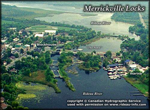 |
Merrickville Locks looking WestThe three locks in Merrickville are in a canal channel built to bypass the original mills built by William Merrick (located near where Ayling's Marina now sits). Merrickville hosts the largest of four blockhouses built along the Rideau, it is located adjacent to the upper lock. Overnight docking is available at the Parks Canada docks in "The Pond."
photo copyright © Canadian Hydrographic Service - used with permission |
Comments: send me email: Ken Watson
©1996- Ken W. Watson
|