Your location: Rideau Canal Home Page > Rideau Lockstations > Poonamalie Lock 32
| Number of locks: 1 |
Total Lift: 1.7m ( 5.7 ft.) |
Lock Through Time: 15 min.* |
| Chart No: 1513 (Sheet 1) |
GPS:1 N 44° 53.580' W 76° 03.340' |
| Chart Sales: No |
Lockstation Tel: 613-283-3543 |
| Washrooms: Yes2 |
Drinking Water: Yes3 |
Day Use Docking: Yes |
| Overnight Mooring: Yes |
Docking4 Upstream: 91m/300' |
Docking4 Downstream: 46m/150' |
| Ice: No |
Power**: Yes (U) |
Boater Camping:5 Yes |
| Boat Launch: Yes |
Picnic Tables: Yes |
BBQ Grills: Yes |
| Parking: Yes |
Public Telephone: No |
Self Guided Trail: Yes |
| Hwy Access: 3 km N of Hwy. 15 on Poonamalie Rd. |
Lock Connects: Rideau River to Lower Rideau Lake |
| Civic Address: 22 Poonamalie Road, Rideau Lakes, Ontario |
| Special Notes: To ensure passage, boaters must arrive at least 30 minutes prior to closing. |
| Of Interest: This odd name dates back to the time of canal construction. The cool cedars in this area reminded one of the British soldiers of a previous posting in Poonamallee, India, a garrison town used by the British army. It was also known as First Rapids, being the first set of rapids on the Rideau River. Have a look at the beautiful lockmaster’s house, still home to today’s Lockmaster, one of only three still in use by lockmasters on the Rideau. Take a hike to the dam and weir, a 1km trail leads to the upstream control dam - very scenic. The dense cedars provide cool shade and an enchanting scent. The location of the dam, at the bottom end of Lower Rideau Lake, is susceptible to spring ice damage. In April 1904, a 300 foot (91 m) wide sheet of ice opened up a 75 foot (23 m) hole in the weir. The dam and weir were then re-done in concrete. In 1971 the dam was again rebuilt, this time a large hydraulic gate replaced the wooden stop logs previously in use. |
| Notes: Closest gas is upstream at Rideau Ferry. There are no local services. |
|
* Time to actually go through the locks. Allow at least twice this time when trip planning. See Schedule Caveats.
** U = upstream side, D = downstream side
1) GPS data should not be used for navigation. See the GPS page.
2) Washrooms are wheel chair accessible.
3) Unless indicated otherwise, water at the lockstation is potable.
4) Includes both blueline and greyline docking - see Lockstation Docking Page.
5) Allows tent camping for those arriving by water and also for cyclists and hikers.
|
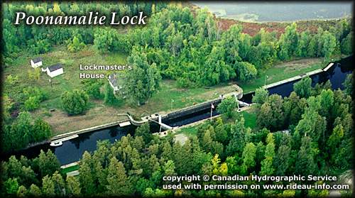 |
Poonamalie Lock looking NorthThe lock at Poonamalie is in the middle of an artificial canal channel that cuts off a particularly winding part of the Rideau River. It is a very quiet lock, it makes a nice picnic stop.
photo copyright © Canadian Hydrographic Service - used with permission |
Comments: send me email: Ken Watson
©1996- Ken W. Watson
|