Poonamalie - Lock 32
(also known as: First Rapids)
| location map | lockstation information |
The Setting
This location had the first set of rapids at the head of the Rideau River. The rapids were 240 yards (220 m) in length, descending in that distance 8 feet, 5 inches (2.6 m), and with a depth of water over the site where it was proposed to construct a dam of 1 foot, 3 inches (0.4 m).
MacTaggart in his 1827 survey noted that "These are a chain of small rapids, where the river banks are low and swampy, where the bed of the river is the above mentioned rock [long ledges of hard plutonic rock], and where, we neither can dam, deepen, nor yet cut through the country."
The Plan
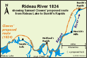 Samuel Clowes’ original plan in 1824 was to bypass First Rapids to the northwest. His canal cut would have started below Edmunds rapids, loop overland to the north of Smyth’s Falls, and then return to the Rideau River, near the outlet of Rideau Lake (now Lower Rideau Lake). A single lock would have been placed in the canal cut near First Rapids. Samuel Clowes’ original plan in 1824 was to bypass First Rapids to the northwest. His canal cut would have started below Edmunds rapids, loop overland to the north of Smyth’s Falls, and then return to the Rideau River, near the outlet of Rideau Lake (now Lower Rideau Lake). A single lock would have been placed in the canal cut near First Rapids.
By's original plan was to essentially follow Clowes' planned line north of the river, creating a canal cut and placing a lock with 7 feet (2.1 m) of lift, with walls and gates an additional 3 feet (0.9 m) high to guard against spring flooding, at the foot of the rapids. The canal cut would be formed by constructing embankments to the head of the rapids, where a dam, 4 feet (1.2 m) in height and 260 feet (79 m) long, would be constructed. This dam would place 5 feet (1.5 m)of water over the upper sill of the lock, and it would raise the level of Rideau Lake by 3 feet (0.9 m).
The plan had to be changed shortly after work commenced, when the line for the canal was cleared and re-surveyed. It was found that the original survey was in error and that the banks of the river were lower than originally thought. Also, if kept to the original line, the canal cut would have been on hard limestone shelving rock, upon which it would have been difficult to form a watertight embankment. So By decided to move the cut to the south of the river, into a swampy area, where he felt that digging and embanking would be easier. The position of the lock was moved to centre point of the canal cut in order to "avoid building Masonry upon open Shelving Rock." The dam was still planned to be put in place at the top of the canal cut.
Building the Locks
The contract was awarded to Ferguson and Wylie.
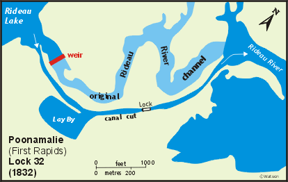 The dam, originally proposed to be an earth and rock filled structure, was changed to be a weir across the whole river, constructed of wood using stone pier abutments. It was 365 feet (111 m) long, built to a height of 6 feet (1.8 m). It was noted that four of the bays (sluices) could be removed entirely to allow the water level to be dropped enough to work on the banks of the upper canal cut. Also, the whole top row of timber on the weir could be removed to "prevent any great rise of the lake in the spring." The dam, originally proposed to be an earth and rock filled structure, was changed to be a weir across the whole river, constructed of wood using stone pier abutments. It was 365 feet (111 m) long, built to a height of 6 feet (1.8 m). It was noted that four of the bays (sluices) could be removed entirely to allow the water level to be dropped enough to work on the banks of the upper canal cut. Also, the whole top row of timber on the weir could be removed to "prevent any great rise of the lake in the spring."
The lock was built in a section with stiff clay and boulders. The sills and part of the breastwork were made of cement, but the floor was made of wood, hemlock planks placed upon large sleepers, also made of hemlock. The top of the lock stood 4 feet, 8 inches (1.4 m) above the normal water level to guard against spring flooding. The lock was built with a lift of 6 feet, 4 inches (1.9 m).
Since the banks of the river were lower than originally surveyed, it would have taken a great deal of work to raise the required embankments, so By opted to deepen the upper and lower canal cuts in order to achieve sufficient navigation depth. A lay-by for vessels was excavated on the south side of the upper canal cut, about halfway between the head of the cut and the lock.
The name Poonamalie comes from Poovirundavalli, a town near Chennai (Madras) in India, which became Poonthamalli, that name anglized to Poonamallee. It was a garrison town for the British Army and speculation (Legget) is that the cedar-lined banks of the Rideau River reminded one of the British military men of a previous posting in India. Early references (1830) to this lockstation were as "Poonamallee," the spelling was changed at some later date to Poonamalie.
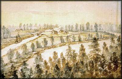 |
First Rapids; ca. 1845
John Burrows, watercolour, Archives of Ontario
The single lock in the artificial canal cut can be seen to the left of the original channel of the Rideau River. There is a defensible lockmaster’s house as well as a couple of buildings left over from canal construction. |
Through the Years
The lock here was called First Rapids by British Ordnance and as Poonamalee by locals. When the canal was handed over from Ordnance to Upper Canada in 1856, the name Poonamalee and later Poonamalie came into common use.
A defensible stone lockmaster's house was built in 1838-1842. A framed second storey was added c.1893.
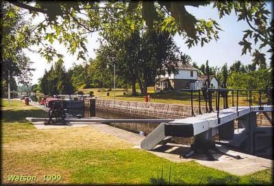 |
Poonamalie Lock and Lockmaster's House
photo by: Ken Watson, 1999 |
For the first few years the lock didn't require much maintenance, but the weir, because of its location at the outlet of Lower Rideau Lake, was susceptible to ice damage.
In 1865, this weir was raised by 2 feet (0.6 m) in order to allow more water to be retained in Big Rideau Lake. It was noted at the time that this didn’t really raise the water in Big Rideau any higher than normal spring levels, but it allowed the longer retention of this level to ensure enough water for navigation throughout the season. In May 1869, the dam was breached by the spring flood and low lying lands as far as Smiths Falls were flooded. In April 1904, a sheet of ice 300 feet (91 m) long and 70 feet (21 m) wide struck the weir, causing a breach 75 feet (23 m) wide. Ice continued to pound the dam until the breach had opened up to 150 feet (46 m). It was recommended that year that the dam be replaced with a new concrete structure.
By the fall of 1904 a new concrete weir had replaced the old timber weir. The elevation of this dam was 1.5 feet (0.5 m) lower than the 1865 level, taking it down to only 0.5 feet (0.1 m) higher than the original 1832 weir height. In 1910, with a hot dry summer, the water level in the upper canal cut dropped to 4 feet 6 inches (1.4 m). To allow more water to be retained in Lower Rideau Lake, work was done in 1911 to raise the banks of the cut and add brackets on the weir, allowing 10 inch (0.25 m) flashboards to be installed. In 1971 a new weir was constructed in concrete, essentially the same height as the 1911 weir. This new weir incorporated a large hydraulic water control gate and also included brackets for 10 inch (0.25 m) flashboards.
The lock underwent extensive repairs in 1907-08 and in 1913 the wooden floor of the lock was redone in concrete.
The lay-by on the south side of the upper canal cut slowly filled in over the years, and is now a marsh.
The Lockmasters to 2000
By's recommendation was James Rutley, a former overseer of works. By 1837, Thomas Richey was lockmaster. In 1844, Richey was transferred to Lower Brewers and was replaced by Daniel Buck. Buck transferred to Old Slys in 1847 and was replaced by William Chalmers, from Bytown. In 1848, Daniel Buck briefly returned and in 1849, Abraham Pearson was lockmaster. In 1871 he was succeeded by his son, William O. Pearson, who resigned in 1911. He was replaced in 1912 by a labourer at the lock, Alfred Best, who served until 1944. Best was followed by unknown from 1944 to 1947; Tom R. Mallows from 1947 to 1955; Morrice Carty from 1955 to 1958; Mark Balfe from 1959 to 1965; Don Bennett from 1966 to 1967; Gerald Hutchison from 1969 to 1971; Jack MacKenzie from 1971 to 1974; Gerald Covell from 1974 to 1985; Lawrence Agnew in 1985; Jack Arnold from 1986 to 1987 and Lawrence Agnew from 1988 to 2000.
|