Upper Brewers Locks 43-44
| location map | lockstation information |
The Setting
The lay of the land prior to the building of the canal was very different than it is today. It was 10.8 miles (17 km) from Jones Falls to where a lockstation was proposed at Brewer’s Upper Mills. The area between Jones Falls and Brewer’s Upper Mills was mostly marshland with one small lake (Cranberry Lake). Water drained in two directions, south, from Loughborough and Dog lakes, through Cranberry Lake, to the Cataraqui River, and east, from the southern Rideau lakes (Newboro, Clear, Indian, Opinicon and Sand) through White Fish Creek (now Morton Creek), to the Gananoque River. The channel of White Fish Creek looped around the south end of Deans Island (then part of the mainland) into Morton Bay and over White Fish Falls (at the present day location of the Morton Dam). To confuse future geographers, what is now known as Lower Beverley Lake was then known as White Fish Lake (or sometimes Henderson Lake).
There was almost no settlement in the area. Lemuel and Carey Haskins built a sawmill and mill dam at White Fish Falls [Morton] in about 1803, turning part of the flow from the White Fish River into the Cranberry Flood Plain and from there to the Cataraqui River. They later (sometime prior to 1816) put up a dam at the Round Tail to stop the escape of water down the Cataraqui River. This created the Drowned Lands, an area below Jones Falls containing acres and acres of dead standing (drowned) trees. It also made the Cranberry Flood Plain navigable by canoe for the first time, directly connecting the southern pre-canal Rideau lakes with the Cataraqui River for the first time.
In about 1819, John Brewer obtained water rights to the rapids at Upper and Lower Brewers. By 1826 Brewer had a sawmill, gristmill and distillery operating at Upper Brewers.
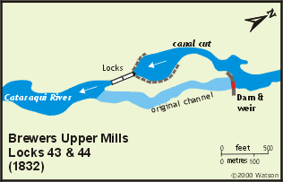
At Brewer’s Upper Mills, the Cataraqui River fell 10 feet, 9 inches (3.3 m), over a series of shallow rapids.
The Plan
Samuel Clowes' recommendation to the Macaulay Commission in 1824 was for two locks in this section, one at Brewer's Upper Mills and one at Round Tail. He advocated adding a waste weir at Round Tail and one at White Fish Falls in order to maintain the flooding of the Cranberry Flood Plain, that this would be a much cheaper solution for navigation than digging a channel through the forest and marsh. This was a pre-cursor to Colonel By's full implementation of a slackwater navigation system.
A portion of Colonel By's plan for the section from Jones Falls to Round Tail stated: "Cranberry Marsh and Lake through which it is proposed to carry the Canal is equally the source of Catarqui and Ganonoqui Rivers, but to render them available, it is necessary to increase their depth, to be effected by constructing a Dam, to serve also as a Waste Weir at the White Fish Falls, the Upper Entrance of the Ganonoqui River, and over which it is anticipated that nearly all the Waste Water between Jones' Falls and Brewer's Upper Mills will flow. The Marsh and Lake in question require to be cleared of Timber and Rushy Islands, and Booms are also to be fixed in the same, to mark the Channel of the Canal, and to prevent the navigation from being interrupted by drift wood. The removal of a Mill Dam at the Round Tail is also provided for."
Basically, By planned to clear a navigation channel through the marsh, marking the sides of it with log booms which would also serve to keep driftwood from entering the channel. At White Fish Falls, he planned to remove the old dam and build a new dam and waste weir. The dam at Round Tail was to be removed entirely.
At Brewer's Upper Mills, MacTaggart proposed a 50 foot (15.2 m) long dam with an 80 foot (24.4 m) retaining wall. The dam, to be placed above Brewer's mill dam, was to be 9 feet (2.7 m) high. It was intended to raise the existing level of the Cranberry Lake and the Drowned Land by 2 feet 6 inches (0.8 m). It would throw the water into a side channel in which two locks would be built, each with a lift of 9 feet (2.7 m). The channel below the locks would be excavated 6 feet (1.8 m) deep for a length of 800 feet (244 m). At that point it would have navigation depth on its own from water thrown up by the dam and lock at Brewer's Lower Mills.
By's final plan at Brewer's Upper Mills was two locks of 9 foot (2.7 m) lift each and a dam, 100 feet (30.5 m) long and 10 feet (3.5 m) high.
Building the Locks
Cranberry Marsh Section:
The contract for this section of the Rideau was awarded to John Brewer, the owner of the local mills.
By had to alter his plans quite a bit once work got underway. Due to the recent (1805-1816) flooding of the Cranberry Flood Plain by mill dams, the mud, when disturbed, gave off an odour that John Mactaggart likened to "a cadaverous animal in the last stages of decomposition." Dysentery and malaria competed with the black flies and mosquitoes in this area, creating difficult summer working conditions. The dams at Round Tail and White Fish Falls were opened to drop the water level and allow access to clear the navigation channel.
By had a wide swath of the dead standing timber cut down, much of that work done in winter on the ice, in order to allow for free air circulation which he believed would reduce the problems with malaria, which at the time was attributed to noxious air.
When the larger locks were decided upon in 1828, By needed to clear a wider and straighter channel to allow for steamboat navigation. He also did away with his plans for log booms to delineate the channel since he realized they would require a great deal of maintenance.
In his 1831 report, By stated: "Having ascertained the necessity of deepening Cranberry Marsh and Lake in places, to provide for a Steam Boat Navigation beyond what was at first anticipated, I deemed it expedient to increase the height of the Works at Brewers Upper Mills, and of the Dam or Waste Weir at the White Fish Falls, to give an additional 2 feet in depth over the same, from the consideration that it was the most judicious mode that could be adopted to lessen as much as possible the expense which must unavoidably be incurred in obtaining the necessary depth of water, and as Cranberry Marsh and Lake are amongst the most unhealthy spots on the Line of Canal, I have cleared a greater space of standing Timber than was originally contemplated to afford a free circulation of air, and also to do away with the necessity of Booms, which after every possible care had been taken in their construction, would have been insecure works, perpetually liable to receiving accidents from Steam Boats and other causes, and thereby entailing a constant expense in order to keep them in repair."
In addition to the above, a problem with floating vegetation arose; "it has also been ascertained that many of the Mossy and rushy Islands in Cranberry Marsh and Lake, rise with the water rendering their removal in consequence necessary; …"
By bought out Haskins’ dam and water rights at White Fish Falls in 1827 and had a new timber waste weir constructed to replace the mill dam.
Brewer's Upper Mills Section:
 The contract for this section of the Rideau was awarded to John Brewer, the owner of the local mills. Brewer quit the job in 1831 due to financial difficulties and left Canada. Robert Drummond, the contractor at Kingston Mills, took over the job, although only after being offered a price 40% higher than that paid to Brewer. The contract for this section of the Rideau was awarded to John Brewer, the owner of the local mills. Brewer quit the job in 1831 due to financial difficulties and left Canada. Robert Drummond, the contractor at Kingston Mills, took over the job, although only after being offered a price 40% higher than that paid to Brewer.
Initially Colonel By planned to place two locks in the channel of the Cataraqui River just above Brewer's mills. Accordingly he bought the mills and property from John Brewer. A bywash was to be constructed around the west side of the locks. By 1828, By had changed his plans, placing a canal dam and weir in the river channel with the two locks in the excavated cut. He originally proposed the locks to be placed at the head of the cut, but then changed location to the bottom of the cut, the configuration that we see today. This change of configuration from the locks in the channel to the locks in the cut also allowed the mills to remain intact.
Given the difficulty of channel clearing in the Cranberry Marsh, By also decided to add two feet of height to his dam in order to add a greater depth of water over the marsh. The dam was to raise the water by 18 feet (5.5 m). He also incorporated waste weir into the dam in order to control water levels. The waste weir here was not as large as might have been normally installed, since the main control for the level of Cranberry Lake and Marsh was to be the weir at White Fish Falls. The dam was built of timber, backed with stone, and fronted with gravel and clay.
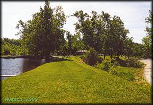 |
Upper Brewers - Embankment
photo by: Ken Watson, 2000
This grassy knoll is the shorter embankment on the west side of the upper basin. The lockstation office behind the upper lock is just visible in the centre of the photo. |
A canal cut was excavated around the west side of the original channel. It was about 1,600 feet (488 m) long, excavated through clay and gravel. Two locks with a total lift of 17 feet, 6 inches (5.3 m), were constructed. A four foot (1.2 m) guard (height above normal water level) was put on the upper lock. Immediately above the lock, a basin was excavated to give room for vessels to pass each other. From the top of the basin to the bottom of the locks, an embankment, nine feet (2.7 m) high and 176 yards (161 m) long, with an impervious clay puddle core, was built on the east side of the cut to contain the raised water. A shorter embankment was built on the west side of the basin.
The dressed stone for the locks were hauled in from a quarry 6 miles (10 km) away. The floors of the locks were made of wood, By considering this to be as durable and much cheaper than the other option of using an inverted arch made out of stone.
The major difficulty encountered during construction was malaria. The workforce at the site totalled about 110 men. During the "sickly season" most of these men was laid low with malarial fever. Wives and children of the workers, living at the work site, suffered from the effects of malaria as much as the men.
In the spring of 1832, a near calamity occurred when a temporary private dam near Loughborough Lake broke and the rushing waters inundated the works at Upper Brewers. By wrote "I have the honor to report for the information of the Master General and Right Hon'ble & Hon'ble Board, that a few days since, a temporary dam broke away which was improperly erected by a private Individual at Ansley's Mills on the South East outlet from Lough'borough Lake, and was formed of rough boards and Slabs, intended to Keep a head of Water on the Lake about two feet higher than the original Saw Mill Dam - this Lake contains from 16 to 18 Square Miles, and is about 19 feet above the level of the Rideau Lake - consequently, when this temporary Dam gave way, the whole of the water, so raised, rushed into Cranberry Marsh, and caused a greater pressure on the embankments and Gates at Brewers Upper Mills, than could have been anticipated, but, fortunately, did little or no injury, except that of carrying away the Coffer Dam in front of the Works at Brewers Upper Mills. To prevent the damage that might arise to the Works by the recurrence of a similar accident, I have taken upon myself the responsibility of directing that a safety Gate be constructed at Brewers Upper Mills, agreeably to the Enclosed Plan, the expense of which shall, be reported as soon as ascertained, and I trust that the whole of the Canal will again be open to the public in the course of 18 or 20 days. …. [this event] points out the necessity of vesting in the Officers Commanding on the Rideau Canal the control of all waters above the level of the Rideau Lake, whose duty it should be to inspect all Mills Dams erected by private individuals in such situations as their failure would create injury to the Works, and have authority to cause their being strengthened, if found necessary - to prevent the navigation from being at any time interrupted."
The safety gate that By refers to was of his own design and one was also put in place at the Isthmus (Newboro). It lay flat on the bed of the canal, and pivoted on a horizontal axis. A rush of water such as that released by a broken dam, would cause the gate to pivot into an upright position, damming the canal.
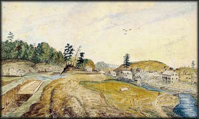 |
Brewer's Upper Mills; Upper Lock partly built, Excavations, Embankments &c in progress, May 1830
Thomas Burrowes, watercolour, Archives of Ontario
This painting shows the locks being constructed. The excavation for the lower lock has been completed, while in the upper lock, the timber sleepers (foundation) have been laid and the walls are being built. Above the lock, an embankment with a clay puddle core has been built to hold back the water in the artificial canal channel, located above the original Cataraqui River channel to the right. Most of the buildings located adjacent to the original channel belong to John Brewer. |
Through the Years
In 1838, following the rebellion in Upper Canada, there were worries about the safety of the canal. A vulnerable spot was the dam at Whitefish Falls, which, if destroyed, would render the section from Upper Brewers to Jones Falls un-navigable. Militia forces were sent to defend the dam. However there was no accommodation nearby, so a temporary guardroom was built. By the fall of 1838, funds had been allocated for the construction of permanent guardhouses at Jones Falls and the Whitefish Dam. Lockmaster Sweeney from Jones Falls and his canalmen, along with Lockmaster Purcell from Davis built a timber guardhouse on top of the rocky cliff on the northwest side of the dam. It had the same dimensions as the one built at Jones Falls, 20.5 feet by 22.5 feet (6.2 x 6.5 m) and 10.5 feet (3.2 m) high It was built of squared cedar timber on a rough stone foundation. The joints between the timbers were mortared. There were loopholes on all sides which were framed and covered with glass. There were militia stationed at the guardhouse until 1842. It was kept up as a military building until the Rideau was handed over from the Ordnance Department to provincial civilian authorities in 1856. After 1856 it was rented out to individuals for seasonal use until finally abandoned in 1900. By the early 1920s it had deteriorated to the point that the roof was caving in. It was deemed a safety hazard and completely dismantled in 1929.
In 1842 a defensible stone lockmaster's house was built near the upper end of the canal cut. It was basically identical in construction to the many defensible stone lockmaster's houses being built along the canal during that period, built of stone, square, about 27 feet (8.2 m) on each side.
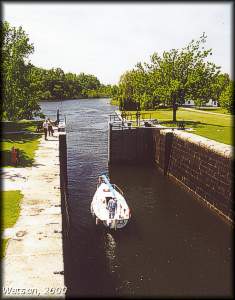 |
Lower Lock - Upper Brewers
photo by: Ken Watson, 2000
A boat heads out of the lower lock at Upper Brewers. Just a few meters downstream, the navigation channel meets the Cataraqui River which enters from the left. |
The safety gate that had been placed above the locks in 1832 was removed in 1847.
In 1861 the lower sill of the lock was repaired and in 1873 a new bottom was laid in the locks to prevent water leakage. In 1910-11 more extensive repairs were made when the upper part of the upper lock and north wall of the lower lock were completely rebuilt in new stone. It was at this time that the basin above the locks was reconstructed in heavy cut stone and the stoplog opening in the weir increased by 3 feet 6 inches (1.1 m) to accommodate spring runoff.
In the mid-1830s, both a sawmill and gristmill were operating here, likely Brewer’s old mills. These were shut down by 1845. William Anglin of Kingston built a new sawmill in 1851, but it was closed by the end of the century due to lack of timber.
Sometime prior to the turn of the century, a grist mill was built on the spot the power plant occupies today. A large house, which later operated as a hotel, was built nearby. In 1939 these two buildings were burned down to make way for the hydro generating station, built by the Gananoque Light and Power Company. The hydroelectric plant is still being operated by Gananoque Light and Power (now called Granite Power).
The Lockmasters to 2000
The first lockmaster at Upper Brewers is unknown. Colonel By in his lockmaster recommendations indicated that there was already a lockmaster appointed for this station. At some point, William Brady was appointed lockmaster, serving here until he drowned in 1835. For a brief time in late 1835, John Purcell, lockmaster at Davis Lock, served here. In early 1836 Purcell returned to Davis Lock, and William Broad who had replaced him at Davis, came to Upper Brewers. Broad was suspended for drunkenness in 1840 and was temporarily replaced by lock labourer William Muchmore. Broad was transferred to Black Rapids and was replaced by the Black Rapids lockmaster, Phillip Clogg. Clogg served until his transfer to Hartwells in 1847. It's interesting to note that malaria still plagued this area, Clogg's family is noted as having suffered from fever and ague (malaria). He may have been replaced by Henry Bullen of Hartwells. In 1856 Patrick Deane became lockmaster, serving there until his death in 1898. He was succeeded by Thomas Todd of Joyceville who retired in 1918. Frank Donaldson served as Lockmaster from 1919 to 1924. He was followed by Peter Milne from 1924 to 1943; Frasier Bell from 1944 to 1948; Reg Woods in various periods from 1946 to 1973 (unclear if he served here continuously in that period); Chester Gains from 1973 to 1975; Bob Martin from 1976 to 1982; Vince Watters from 1982 to 1985; Albert Mills from 1985 to 1986; T.H. Fielding from 1986 to 1997; unknown from 1998 to 1999 and Peter O'Meara in 2000.
|