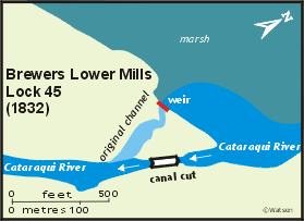
Lower Brewers Lock 45
| location map | lockstation information |
The Setting
At Brewer's Lower Mills (called "New Mills" by Samuel Clowes in 1824) the Cataraqui River fell 13.5 feet (4.1 m) over a series of rapids. About a mile and half (2.4 km) below Brewer's Lower Mills were Billidore's Rifts (now the area of the upper end of River Styx). These "rifts" were a set of small rapids, dropping four feet (1.2 m) over the course of a mile (1.6 km). About 5 miles (8 km) below these, about a mile and half (2.4 km) upstream of Kingston Mills were Jack's Rifts, a gentle series of small rapids, about 500 feet (152 m) long and 1 foot 6 inches feet (0.5 m) deep, at the outlet of a marshy area (now the lower end of River Styx). It was noted that much of the Cataraqui River, outside of the rifts, was about 4 feet (1.2 m) deep, almost navigable water depth.
The Plan
The plan submitted by Samuel Clowes in 1824 consisted of single locks at Brewer's Lower Mills, Billidore's Rifts and Jack's Rifts (three locks in total). In between these locks, the line of the canal would be straightened, cutting off all the curves of the natural route of the Cataraqui River.
John Burrows, in the diary of his second survey of the Rideau route in July 1827, in commenting on Clowes' plan, wrote: "… it was with a feeling of regret that [we] found Mr. Clows has laid out and done considerable work in forming the line of the canal from Kingston Mills to Brewers Mills in direct hostility to the kindness of Divine Nature, who has formed the canal, with but few exceptions for the whole of that distance, in gentle curves, as Hogarth has it 'lines of beauty'. This to the modern engineer is gall and bitterness, apart from the immense expense incurred. Nature may be improved by Science, but never altered."
The original plan was similar to that put forward by Clowes, with the exception that more of the Cataraqui channel was to be used, with only a few sharp bends to be excavated. At Brewer's Lower Mills, a canal cut was to be excavated around the mill works so as to leave them undisturbed. A lock of 10 feet 7 inches (3.2 m) depth was proposed. The mill dam, which held back 11 feet (3.4 m) of water, was to be maintained.
At Billidore's Rifts a lock with a lift of 5 feet (1.5 m) and wing walls to block the channel (instead of a dam) was proposed. Exactly the same was proposed for Jack's Rifts.
Before the contracts were released, plans had changed. It was realized that extensive rock work would be required at Kingston Mills. By decided to add an extra lock and increase the height of the dam at Kingston Mills so that he could build his locks on top of the rock, rather than having to excavate down through it. This proposal put enough head of water over Jack's Rifts and Billidore's Rifts as to preclude the need for dams and locks at these locations.
Building the Locks
The first contractor was Samuel Clowes, the civil engineer and surveyor for the Macaulay Commission. He was awarded the contract for the construction of the dam and locks at Brewer’s Lower Mills, and for excavation work to straighten and widen the channel for six miles (10 km) downstream. Clowes died in September 1828 and the works at Lower Brewer’s Mills were taken over by Robert Drummond, the contractor at Kingston Mills.
 It was originally planned to keep the existing mill structures intact by using an artificial canal cut to bypass the mill buildings. The first problem was not with nature but with the operator of the mills, a Colonel McLean who apparently wasn't too keen on the canal being built near his works. In a letter to Colonel By dated July 25, 1827, Clowes wrote: "I have nothing but trouble, Colonel McLean is doing all he can to put a stop to the Canal, he has overflowed the whole work 4 times and me and eighty men have had to stand for two or three days' each time till the water was drained off, and there it leaves the land all over mud; and makes it so sickly it is not possible to keep labourers on the ground. This is just the situation I am in. …" By ordered guards to be posted to prevent McLean from flooding the works again. It was originally planned to keep the existing mill structures intact by using an artificial canal cut to bypass the mill buildings. The first problem was not with nature but with the operator of the mills, a Colonel McLean who apparently wasn't too keen on the canal being built near his works. In a letter to Colonel By dated July 25, 1827, Clowes wrote: "I have nothing but trouble, Colonel McLean is doing all he can to put a stop to the Canal, he has overflowed the whole work 4 times and me and eighty men have had to stand for two or three days' each time till the water was drained off, and there it leaves the land all over mud; and makes it so sickly it is not possible to keep labourers on the ground. This is just the situation I am in. …" By ordered guards to be posted to prevent McLean from flooding the works again.
It was also discovered that the original survey between Upper and Lower Brewer's Mills had an error of 1 foot, 7 inches (0.5 m). In order to accommodate this error, and also save expenses involved in deepening the channel between Lower and Upper Brewers, By decided to raise the elevation of the lock by 3 feet 7 inches (1.1 m). In the end, By ended up making the lock 13 feet, 2 inches (4.0 m) in elevation, sufficient to throw a 7 foot (2.1 m) depth of water into the lower lock at Upper Brewers.
By eventually purchased the mill buildings so that he could create his works through the area with no conflicts. He replaced the original mill dam with a 13 foot (4.0 m) high timber waste weir, located slightly downstream on a ridge of bedrock. By noted that the weir was constructed such that the water above the lock could be drawn down to below the level of the upper sill, so that future repairs could more easily be made.
It was originally proposed to build the lock on inverted stone arches, but the quality of the clay foundation and the cost saving entailed made By choose to put in a wood floor. He noted that wood, when kept under water, was as durable as stone.
The lock was built somewhat in haste because of the severeness of malaria that would strike down most of the workforce every summer. The southern Rideau was particularly hard hit by seasonal outbreaks of malaria. As much work as possible was done in the winter, and during summer, some corners were cut to speed up construction.
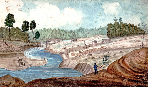 |
Brewer's Lower Mill; Masonry of the Lock nearly completed, Excavation for the Canal in progress, 1831-32
Thomas Burrowes, watercolour, Archives of Ontario
The lock, constructed “in the dry” in the canal cut is almost complete. A coffer dam at the lower end keeps the water from the original channel of the Cataraqui River out of the works. At the head of the former channel a waste weir has been constructed to control the level of water above the lock. On the left side, labourers are hand dredging the riverbank to provide a direct navigation entrance to the lock. The stones for the lock are being lifted into place using a shear leg system (2 timbers supported by ropes), the stones lifted using rock tongs at the end of a block and tackle pulley. The dimples you see today in original stones are the chiselled out spots for the tongs to grab onto the stone. |
The Channel
The Cataraqui River in the pre-canal era was a meandering creek. The present straight navigation channel (marked with buoys) through the upper end of Colonel By Lake and River Styx represents a 200 foot wide swath of forest being cut down prior to the area being flooded. The satellite photo below of the upper end of River Styx shows this quite clearly:
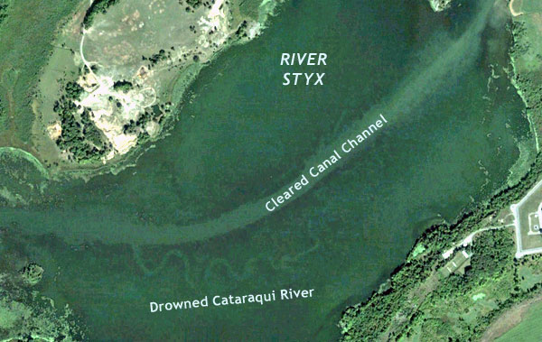
This 2005 satellite image from Google Earth shows part of the meandering Cataraqui River now sitting under 7 to 8 feet of water, the flooding caused by the dam and berms at Kingston Mills. The original Cataraqui River was about 60 feet wide and only a few feet deep. The cut channel through the now drowned forest is 200 feet wide.
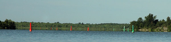
The view from the water is of red and green navigation buoys marking the cleared channel.
Through the Years
This lock caused many of problems due to its poor foundation. It leaked badly and required constant grouting and pointing. It was recommended as early as 1840 that the lock be completely rebuild. However, the Board of Works in its attempts at economy did not authorize a complete rebuilt. In 1860, some reconstruction was started with the rebuilding of one the lower wing walls. In 1861, the east wall, which was being supported by iron straps bolted to posts driven into the earth embankment, collapsed. It was reported that the only thing holding up the lock wall was the wooden lock gate, which also received damage.
More problems plagued the lock. In 1874, the west (northwest) chamber wall was rebuilt. In 1905-06 and 1906-07 the lock was again rebuilt. Superintendent Phillips stated "This lock has always given trouble, as it is located in the wrong place, and is built on cross timbers bedded into a very poor foundation of soft clay and sand." Repairs to the lock were a constant necessity through the years. This led finally to a total reconstruction of the lock in 1977 using the original stone.
In the early 1840s a defensible stone lockmaster's house, 27 feet (8.2 m) on a side, was built here. In about 1899, a second framed wooden storey was added to the building.
In 1861, a settler named James C. Foster built a grist mill at this site. He later added a woollen mill and store. A storage elevator was built beside the grist mill in about 1865.
A timber swing bridge was built across the lock in 1872. It was an unequal arm, center bearing timber swing bridge (sometimes erroneously called a Kingpost Truss swing bridge). It has been repaired/replaced over the years while maintaining the same design. It was last replaced, including the abutments, in 2022-23. It is one of only four such timber swing bridges remaining on the Rideau Canal (the others are at Brass Point, Kilmarnock and Nicholsons).
The name Washburn was coined by the first postmaster (the lockmaster, John McGillivray) in about 1873. The name means "weirstream," combining the Scottish word "burn," meaning stream and "wash" for the old word "bywash" meaning water flowing from a waste weir. The names Washburn and Lower Brewers Mills have been used interchangeably since that time.
The clapboard house at this site was built in about 1930.
In 1942 a hydroelectric station was built to use the surplus waste weir water. The old grist mill was torn down and the hydro station built on its foundation. The milling machinery was moved into the old storage elevator and operated, serving local needs, up to the 1960s. The hydroelectric station operated until 1970. Both the hydro station and the old storage elevator are still standing.
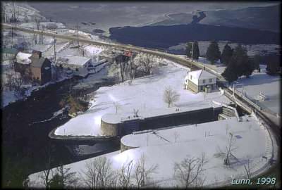 |
Aerial View of Lower Brewers
photo by: Simon Lunn, 1998
This photo shows the configuration of the lock placed in an artificial channel, with the weir behind it, blocking the original route of the Cataraqui River. The old power station sits below the weir and the defensible locksmaster’s house sits beside the lock. |
The Lockmasters to 2000
The first lockmaster, recommended by Colonel By, was Thomas Green, a corporal in the 7th Company, Royal Sappers and Miners. He seems to have been replaced in about 1834-45 by James Callaway, also of the 7th Company, Royal Sappers and Miners. For a brief period, 1844 to mid-1846, Thomas Richey of First Rapids (Poonamalie) was lockmaster. He was dismissed (unfit for duty) in 1846 and replaced by Richard Carey, who was himself replaced in 1851 by William Beal. In 1855 Beal was succeeded by William Robinson who was transferred to Kingston Mills in 1856. His successor was John McGillivray who retired in 1882, and was replaced by his son Henry McGillivray. Henry died in 1891 and was replaced by William Glenn, a lock labourer at the station. He was discharged in 1896 for political patronage reasons but was reinstated in 1897 and served until his death in 1902. Henry McBroom, recommended by a local politician, became lockmaster in 1903 and served until his retirement in 1933. He was followed by S. Woodstock from 1934 to 1937; unknown from 1938 to 1943; Frasier Ball from 1943 to 1944; Percy Gilbert from 1944 to 1954; H.A. Cooper from 1954 to 1956; unknown from 1957 to 1959; J.L. Jones from 1960 to 1965; Byron L. Nixon from 1964 to 1973; Terry Carlo from 1973 to 1979; Albert Mills from 1980 to ?; Doug Langille, acting in the mid 1980s; and P.J. O'Meara from 1986 to 2000.
|